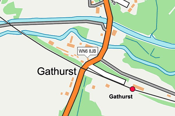
WN6 8JB is located in the Shevington with Lower Ground & Moor electoral ward, within the metropolitan district of Wigan and the English Parliamentary constituency of Wigan. The Sub Integrated Care Board (ICB) Location is NHS Greater Manchester ICB - 02H and the police force is Greater Manchester. This postcode has been in use since January 1980.


GetTheData
Source: OS OpenMap – Local (Ordnance Survey)
Source: OS VectorMap District (Ordnance Survey)
Licence: Open Government Licence (requires attribution)
| Easting | 353957 |
| Northing | 407296 |
| Latitude | 53.560267 |
| Longitude | -2.696565 |
GetTheData
Source: Open Postcode Geo
Licence: Open Government Licence
| Country | England |
| Postcode District | WN6 |
➜ See where WN6 is on a map ➜ Where is Gathurst? | |
GetTheData
Source: Land Registry Price Paid Data
Licence: Open Government Licence
Elevation or altitude of WN6 8JB as distance above sea level:
| Metres | Feet | |
|---|---|---|
| Elevation | 20m | 66ft |
Elevation is measured from the approximate centre of the postcode, to the nearest point on an OS contour line from OS Terrain 50, which has contour spacing of ten vertical metres.
➜ How high above sea level am I? Find the elevation of your current position using your device's GPS.
GetTheData
Source: Open Postcode Elevation
Licence: Open Government Licence
| Ward | Shevington With Lower Ground & Moor |
| Constituency | Wigan |
GetTheData
Source: ONS Postcode Database
Licence: Open Government Licence
| Gathurst Rd/Gathurst Stn (Gathurst Rd) | Gathurst | 34m |
| Gathurst Rd/Gathurst Stn (Gathurst Rd) | Gathurst | 37m |
| Gathurst Ln/Gathurst Hall Farm (Gathurst Ln) | Gathurst | 224m |
| Gathurst Ln/Gathurst Hall Farm (Gathurst Ln) | Gathurst | 229m |
| Gathurst Rd/Ackhurst Ln (Gathurst Rd) | Gathurst | 523m |
| Gathurst Station | 0.2km |
| Appley Bridge Station | 2.5km |
| Orrell Station | 3.4km |
GetTheData
Source: NaPTAN
Licence: Open Government Licence
GetTheData
Source: ONS Postcode Database
Licence: Open Government Licence


➜ Get more ratings from the Food Standards Agency
GetTheData
Source: Food Standards Agency
Licence: FSA terms & conditions
| Last Collection | |||
|---|---|---|---|
| Location | Mon-Fri | Sat | Distance |
| Shevington P O | 18:35 | 12:25 | 1,189m |
| Kitt Green Post Office | 18:50 | 11:55 | 1,926m |
| 12 Roby Mill | 18:30 | 11:00 | 2,206m |
GetTheData
Source: Dracos
Licence: Creative Commons Attribution-ShareAlike
The below table lists the International Territorial Level (ITL) codes (formerly Nomenclature of Territorial Units for Statistics (NUTS) codes) and Local Administrative Units (LAU) codes for WN6 8JB:
| ITL 1 Code | Name |
|---|---|
| TLD | North West (England) |
| ITL 2 Code | Name |
| TLD3 | Greater Manchester |
| ITL 3 Code | Name |
| TLD36 | Greater Manchester North West |
| LAU 1 Code | Name |
| E08000010 | Wigan |
GetTheData
Source: ONS Postcode Directory
Licence: Open Government Licence
The below table lists the Census Output Area (OA), Lower Layer Super Output Area (LSOA), and Middle Layer Super Output Area (MSOA) for WN6 8JB:
| Code | Name | |
|---|---|---|
| OA | E00032426 | |
| LSOA | E01006396 | Wigan 011B |
| MSOA | E02001297 | Wigan 011 |
GetTheData
Source: ONS Postcode Directory
Licence: Open Government Licence
| WN6 8HZ | Gathurst Lane | 148m |
| WN5 0LL | Gathurst Road | 280m |
| WN6 8FP | Ellwood Gardens | 293m |
| WN6 8JD | Gathurst Lane | 456m |
| WN6 8JE | Greenvale | 507m |
| WN5 0LW | Ackhurst Lane | 518m |
| WN6 8HY | Princes Park | 550m |
| WN6 8HS | Gathurst Lane | 572m |
| WN5 0LH | Gathurst Road | 607m |
| WN6 8HX | Queensway | 649m |
GetTheData
Source: Open Postcode Geo; Land Registry Price Paid Data
Licence: Open Government Licence