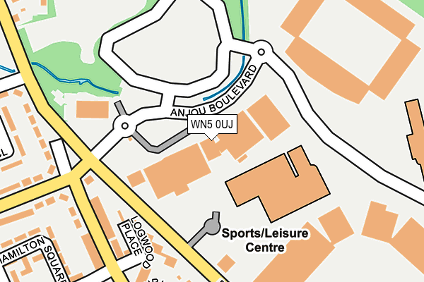
WN5 0UJ lies on Anjou Boulevard in Wigan. WN5 0UJ is located in the Douglas electoral ward, within the metropolitan district of Wigan and the English Parliamentary constituency of Wigan. The Sub Integrated Care Board (ICB) Location is NHS Greater Manchester ICB - 02H and the police force is Greater Manchester. This postcode has been in use since December 1996.


GetTheData
Source: OS OpenMap – Local (Ordnance Survey)
Source: OS VectorMap District (Ordnance Survey)
Licence: Open Government Licence (requires attribution)
| Easting | 356568 |
| Northing | 405721 |
| Latitude | 53.546319 |
| Longitude | -2.656932 |
GetTheData
Source: Open Postcode Geo
Licence: Open Government Licence
| Street | Anjou Boulevard |
| Town/City | Wigan |
| Country | England |
| Postcode District | WN5 |
➜ See where WN5 is on a map ➜ Where is Wigan? | |
GetTheData
Source: Land Registry Price Paid Data
Licence: Open Government Licence
Elevation or altitude of WN5 0UJ as distance above sea level:
| Metres | Feet | |
|---|---|---|
| Elevation | 30m | 98ft |
Elevation is measured from the approximate centre of the postcode, to the nearest point on an OS contour line from OS Terrain 50, which has contour spacing of ten vertical metres.
➜ How high above sea level am I? Find the elevation of your current position using your device's GPS.
GetTheData
Source: Open Postcode Elevation
Licence: Open Government Licence
| Ward | Douglas |
| Constituency | Wigan |
GetTheData
Source: ONS Postcode Database
Licence: Open Government Licence
1A, ANJOU BOULEVARD, WIGAN, WN5 0UJ 2001 26 JUN £424,000 |
GetTheData
Source: HM Land Registry Price Paid Data
Licence: Contains HM Land Registry data © Crown copyright and database right 2025. This data is licensed under the Open Government Licence v3.0.
| Anjou Boulevard (Ebnd) (Anjou Boulevard) | Robin Park | 98m |
| Scot Ln/Montrose Ave (Scot Ln) | Laithwaite | 200m |
| Scot Ln/Montrose Ave (Scot Ln) | Laithwaite | 208m |
| Montrose Ave/Scot Ln (Montrose Ave) | Laithwaite | 233m |
| Scot Ln/Laithwaite Rd (Scot Ln) | Laithwaite | 251m |
| Wigan Wallgate Station | 1.6km |
| Wigan North Western Station | 1.6km |
| Pemberton Station | 2km |
GetTheData
Source: NaPTAN
Licence: Open Government Licence
GetTheData
Source: ONS Postcode Database
Licence: Open Government Licence


➜ Get more ratings from the Food Standards Agency
GetTheData
Source: Food Standards Agency
Licence: FSA terms & conditions
| Last Collection | |||
|---|---|---|---|
| Location | Mon-Fri | Sat | Distance |
| Worsley Hall P O | 17:15 | 12:15 | 769m |
| Wigan Delivery Office | 19:15 | 12:40 | 1,432m |
| Wigan Branch Office | 19:05 | 12:30 | 1,632m |
GetTheData
Source: Dracos
Licence: Creative Commons Attribution-ShareAlike
The below table lists the International Territorial Level (ITL) codes (formerly Nomenclature of Territorial Units for Statistics (NUTS) codes) and Local Administrative Units (LAU) codes for WN5 0UJ:
| ITL 1 Code | Name |
|---|---|
| TLD | North West (England) |
| ITL 2 Code | Name |
| TLD3 | Greater Manchester |
| ITL 3 Code | Name |
| TLD36 | Greater Manchester North West |
| LAU 1 Code | Name |
| E08000010 | Wigan |
GetTheData
Source: ONS Postcode Directory
Licence: Open Government Licence
The below table lists the Census Output Area (OA), Lower Layer Super Output Area (LSOA), and Middle Layer Super Output Area (MSOA) for WN5 0UJ:
| Code | Name | |
|---|---|---|
| OA | E00032202 | |
| LSOA | E01006352 | Wigan 015B |
| MSOA | E02001301 | Wigan 015 |
GetTheData
Source: ONS Postcode Directory
Licence: Open Government Licence
| WN5 9SY | Logwood Place | 175m |
| WN5 0UR | Laurus Mews | 207m |
| WN5 9SX | Scot Lane | 222m |
| WN5 9TA | Scot Lane | 251m |
| WN5 0UF | Laurel Street | 251m |
| WN5 0UE | Scot Lane | 279m |
| WN5 9SZ | Finlay Court | 289m |
| WN5 9SJ | Montrose Avenue | 299m |
| WN5 9SA | Laithwaite Road | 304m |
| WN5 9ST | Gordon Close | 313m |
GetTheData
Source: Open Postcode Geo; Land Registry Price Paid Data
Licence: Open Government Licence