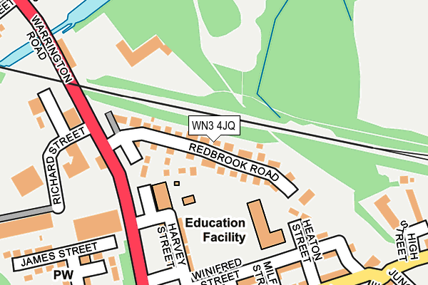
WN3 4JQ lies on Red Brook Road in Ince, Wigan. WN3 4JQ is located in the Ince electoral ward, within the metropolitan district of Wigan and the English Parliamentary constituency of Wigan. The Sub Integrated Care Board (ICB) Location is NHS Greater Manchester ICB - 02H and the police force is Greater Manchester. This postcode has been in use since June 1998.


GetTheData
Source: OS OpenMap – Local (Ordnance Survey)
Source: OS VectorMap District (Ordnance Survey)
Licence: Open Government Licence (requires attribution)
| Easting | 359065 |
| Northing | 404935 |
| Latitude | 53.539455 |
| Longitude | -2.619148 |
GetTheData
Source: Open Postcode Geo
Licence: Open Government Licence
| Street | Red Brook Road |
| Locality | Ince |
| Town/City | Wigan |
| Country | England |
| Postcode District | WN3 |
➜ See where WN3 is on a map ➜ Where is Ince-in-Makerfield? | |
GetTheData
Source: Land Registry Price Paid Data
Licence: Open Government Licence
Elevation or altitude of WN3 4JQ as distance above sea level:
| Metres | Feet | |
|---|---|---|
| Elevation | 40m | 131ft |
Elevation is measured from the approximate centre of the postcode, to the nearest point on an OS contour line from OS Terrain 50, which has contour spacing of ten vertical metres.
➜ How high above sea level am I? Find the elevation of your current position using your device's GPS.
GetTheData
Source: Open Postcode Elevation
Licence: Open Government Licence
| Ward | Ince |
| Constituency | Wigan |
GetTheData
Source: ONS Postcode Database
Licence: Open Government Licence
| Warrington Rd/Redbrook Rd (Warrington Rd) | Lower Ince | 156m |
| Warrington Rd/Frederick St (Warrington Rd) | Lower Ince | 216m |
| Bryn St/Warrington Rd (Bryn St) | Lower Ince | 284m |
| Warrington Rd/Chorley St (Warrington Rd) | Lower Ince | 331m |
| Warrington Rd/Windleshaw St (Warrington Rd) | Lower Ince | 336m |
| Ince (Manchester) Station | 0.5km |
| Wigan North Western Station | 1km |
| Wigan Wallgate Station | 1.1km |
GetTheData
Source: NaPTAN
Licence: Open Government Licence
| Percentage of properties with Next Generation Access | 100.0% |
| Percentage of properties with Superfast Broadband | 100.0% |
| Percentage of properties with Ultrafast Broadband | 98.6% |
| Percentage of properties with Full Fibre Broadband | 0.0% |
Superfast Broadband is between 30Mbps and 300Mbps
Ultrafast Broadband is > 300Mbps
| Median download speed | 65.2Mbps |
| Average download speed | 82.0Mbps |
| Maximum download speed | 350.00Mbps |
| Median upload speed | 5.5Mbps |
| Average upload speed | 7.7Mbps |
| Maximum upload speed | 20.00Mbps |
| Percentage of properties unable to receive 2Mbps | 0.0% |
| Percentage of properties unable to receive 5Mbps | 0.0% |
| Percentage of properties unable to receive 10Mbps | 0.0% |
| Percentage of properties unable to receive 30Mbps | 0.0% |
GetTheData
Source: Ofcom
Licence: Ofcom Terms of Use (requires attribution)
Estimated total energy consumption in WN3 4JQ by fuel type, 2015.
| Consumption (kWh) | 349,436 |
|---|---|
| Meter count | 43 |
| Mean (kWh/meter) | 8,126 |
| Median (kWh/meter) | 7,502 |
| Consumption (kWh) | 224,728 |
|---|---|
| Meter count | 60 |
| Mean (kWh/meter) | 3,745 |
| Median (kWh/meter) | 3,048 |
GetTheData
Source: Postcode level gas estimates: 2015 (experimental)
Source: Postcode level electricity estimates: 2015 (experimental)
Licence: Open Government Licence
GetTheData
Source: ONS Postcode Database
Licence: Open Government Licence


➜ Get more ratings from the Food Standards Agency
GetTheData
Source: Food Standards Agency
Licence: FSA terms & conditions
| Last Collection | |||
|---|---|---|---|
| Location | Mon-Fri | Sat | Distance |
| Swinley Road | 17:55 | 12:00 | 981m |
| Wigan Branch Office | 19:05 | 12:30 | 1,095m |
| Woodville Road | 18:15 | 11:05 | 1,267m |
GetTheData
Source: Dracos
Licence: Creative Commons Attribution-ShareAlike
The below table lists the International Territorial Level (ITL) codes (formerly Nomenclature of Territorial Units for Statistics (NUTS) codes) and Local Administrative Units (LAU) codes for WN3 4JQ:
| ITL 1 Code | Name |
|---|---|
| TLD | North West (England) |
| ITL 2 Code | Name |
| TLD3 | Greater Manchester |
| ITL 3 Code | Name |
| TLD36 | Greater Manchester North West |
| LAU 1 Code | Name |
| E08000010 | Wigan |
GetTheData
Source: ONS Postcode Directory
Licence: Open Government Licence
The below table lists the Census Output Area (OA), Lower Layer Super Output Area (LSOA), and Middle Layer Super Output Area (MSOA) for WN3 4JQ:
| Code | Name | |
|---|---|---|
| OA | E00031962 | |
| LSOA | E01006310 | Wigan 012D |
| MSOA | E02001298 | Wigan 012 |
GetTheData
Source: ONS Postcode Directory
Licence: Open Government Licence
| WN3 4JU | Kellaton Close | 63m |
| WN3 4JR | Baverstock Close | 94m |
| WN3 4SE | Heaton Street | 160m |
| WN3 4SF | Harvey Street | 177m |
| WN3 4SD | Winifred Street | 203m |
| WN3 4RY | Manley Street | 233m |
| WN1 3AJ | Warrington Road | 243m |
| WN3 4SA | Manley Street | 244m |
| WN3 4JS | Warrington Road | 256m |
| WN3 4RX | Bryn Street | 273m |
GetTheData
Source: Open Postcode Geo; Land Registry Price Paid Data
Licence: Open Government Licence