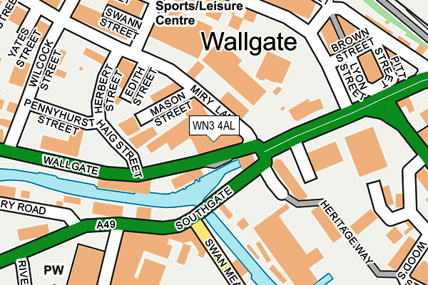
WN3 4AL lies on Wallgate in Wigan. WN3 4AL is located in the Douglas electoral ward, within the metropolitan district of Wigan and the English Parliamentary constituency of Wigan. The Sub Integrated Care Board (ICB) Location is NHS Greater Manchester ICB - 02H and the police force is Greater Manchester. This postcode has been in use since September 1991.


GetTheData
Source: OS OpenMap – Local (Ordnance Survey)
Source: OS VectorMap District (Ordnance Survey)
Licence: Open Government Licence (requires attribution)
| Easting | 357732 |
| Northing | 405290 |
| Latitude | 53.542540 |
| Longitude | -2.639308 |
GetTheData
Source: Open Postcode Geo
Licence: Open Government Licence
| Street | Wallgate |
| Town/City | Wigan |
| Country | England |
| Postcode District | WN3 |
➜ See where WN3 is on a map ➜ Where is Wigan? | |
GetTheData
Source: Land Registry Price Paid Data
Licence: Open Government Licence
Elevation or altitude of WN3 4AL as distance above sea level:
| Metres | Feet | |
|---|---|---|
| Elevation | 30m | 98ft |
Elevation is measured from the approximate centre of the postcode, to the nearest point on an OS contour line from OS Terrain 50, which has contour spacing of ten vertical metres.
➜ How high above sea level am I? Find the elevation of your current position using your device's GPS.
GetTheData
Source: Open Postcode Elevation
Licence: Open Government Licence
| Ward | Douglas |
| Constituency | Wigan |
GetTheData
Source: ONS Postcode Database
Licence: Open Government Licence
| Wallgate/Clayton St (Wallgate) | Wigan | 133m |
| Wallgate/Clayton St (Wallgate) | Wigan | 162m |
| Swan Meadow Rd/Pottery Rd (Swan Meadow Rd) | Wigan Pier | 162m |
| Wallgate/Wigan Pier (Wallgate) | Wigan Pier | 174m |
| Swan Meadow Rd/Pottery Rd (Swan Meadow Rd) | Wigan Pier | 178m |
| Wigan North Western Station | 0.4km |
| Wigan Wallgate Station | 0.5km |
| Ince (Manchester) Station | 1.9km |
GetTheData
Source: NaPTAN
Licence: Open Government Licence
GetTheData
Source: ONS Postcode Database
Licence: Open Government Licence


➜ Get more ratings from the Food Standards Agency
GetTheData
Source: Food Standards Agency
Licence: FSA terms & conditions
| Last Collection | |||
|---|---|---|---|
| Location | Mon-Fri | Sat | Distance |
| Wigan Branch Office | 19:05 | 12:30 | 559m |
| Wigan Delivery Office | 19:15 | 12:40 | 564m |
| Swinley Road | 17:55 | 12:00 | 824m |
GetTheData
Source: Dracos
Licence: Creative Commons Attribution-ShareAlike
The below table lists the International Territorial Level (ITL) codes (formerly Nomenclature of Territorial Units for Statistics (NUTS) codes) and Local Administrative Units (LAU) codes for WN3 4AL:
| ITL 1 Code | Name |
|---|---|
| TLD | North West (England) |
| ITL 2 Code | Name |
| TLD3 | Greater Manchester |
| ITL 3 Code | Name |
| TLD36 | Greater Manchester North West |
| LAU 1 Code | Name |
| E08000010 | Wigan |
GetTheData
Source: ONS Postcode Directory
Licence: Open Government Licence
The below table lists the Census Output Area (OA), Lower Layer Super Output Area (LSOA), and Middle Layer Super Output Area (MSOA) for WN3 4AL:
| Code | Name | |
|---|---|---|
| OA | E00168473 | |
| LSOA | E01006349 | Wigan 015A |
| MSOA | E02001301 | Wigan 015 |
GetTheData
Source: ONS Postcode Directory
Licence: Open Government Licence
| WN3 4EU | Wigan Pier | 50m |
| WN3 4BG | Heritage Way | 96m |
| WN3 4EH | Southgate | 98m |
| WN3 4AF | Miry Lane | 154m |
| WN3 4DU | Heritage Way | 186m |
| WN3 4BE | Heritage Way | 190m |
| WN3 4DA | Clayton Street | 238m |
| WN3 4DP | Tower Enterprise Park | 274m |
| WN3 5AA | Pottery Road | 275m |
| WN3 4ER | Hodson Street | 283m |
GetTheData
Source: Open Postcode Geo; Land Registry Price Paid Data
Licence: Open Government Licence