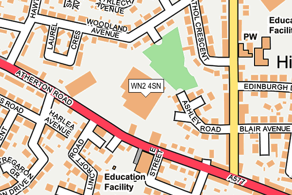
WN2 4SN is located in the Hindley Green electoral ward, within the metropolitan district of Wigan and the English Parliamentary constituency of Makerfield. The Sub Integrated Care Board (ICB) Location is NHS Greater Manchester ICB - 02H and the police force is Greater Manchester. This postcode has been in use since February 1984.


GetTheData
Source: OS OpenMap – Local (Ordnance Survey)
Source: OS VectorMap District (Ordnance Survey)
Licence: Open Government Licence (requires attribution)
| Easting | 363523 |
| Northing | 403383 |
| Latitude | 53.525851 |
| Longitude | -2.551702 |
GetTheData
Source: Open Postcode Geo
Licence: Open Government Licence
| Country | England |
| Postcode District | WN2 |
➜ See where WN2 is on a map ➜ Where is Hindley? | |
GetTheData
Source: Land Registry Price Paid Data
Licence: Open Government Licence
Elevation or altitude of WN2 4SN as distance above sea level:
| Metres | Feet | |
|---|---|---|
| Elevation | 50m | 164ft |
Elevation is measured from the approximate centre of the postcode, to the nearest point on an OS contour line from OS Terrain 50, which has contour spacing of ten vertical metres.
➜ How high above sea level am I? Find the elevation of your current position using your device's GPS.
GetTheData
Source: Open Postcode Elevation
Licence: Open Government Licence
| Ward | Hindley Green |
| Constituency | Makerfield |
GetTheData
Source: ONS Postcode Database
Licence: Open Government Licence
| Atherton Rd/Lincroft Rd (Atherton Rd) | Hindley Green | 98m |
| Atherton Rd/Lincroft Rd (Atherton Rd) | Hindley Green | 127m |
| Atherton Rd/St John's Primary Sch (Atherton Rd) | Hindley Green | 145m |
| Atherton Rd/St John's Primary Sch (Atherton Rd) | Hindley Green | 159m |
| Swan Ln/Athol Cres (Swan Ln) | Hindley Green | 255m |
| Hindley Station | 2.4km |
| Daisy Hill Station | 2.8km |
| Westhoughton Station | 3.8km |
GetTheData
Source: NaPTAN
Licence: Open Government Licence
GetTheData
Source: ONS Postcode Database
Licence: Open Government Licence


➜ Get more ratings from the Food Standards Agency
GetTheData
Source: Food Standards Agency
Licence: FSA terms & conditions
| Last Collection | |||
|---|---|---|---|
| Location | Mon-Fri | Sat | Distance |
| Platt Bridge P O | 18:45 | 12:05 | 294m |
| Sanderlings | 17:10 | 11:45 | 1,708m |
| Hindley Green P O | 18:30 | 11:55 | 1,734m |
GetTheData
Source: Dracos
Licence: Creative Commons Attribution-ShareAlike
The below table lists the International Territorial Level (ITL) codes (formerly Nomenclature of Territorial Units for Statistics (NUTS) codes) and Local Administrative Units (LAU) codes for WN2 4SN:
| ITL 1 Code | Name |
|---|---|
| TLD | North West (England) |
| ITL 2 Code | Name |
| TLD3 | Greater Manchester |
| ITL 3 Code | Name |
| TLD36 | Greater Manchester North West |
| LAU 1 Code | Name |
| E08000010 | Wigan |
GetTheData
Source: ONS Postcode Directory
Licence: Open Government Licence
The below table lists the Census Output Area (OA), Lower Layer Super Output Area (LSOA), and Middle Layer Super Output Area (MSOA) for WN2 4SN:
| Code | Name | |
|---|---|---|
| OA | E00031851 | |
| LSOA | E01006278 | Wigan 019A |
| MSOA | E02001305 | Wigan 019 |
GetTheData
Source: ONS Postcode Directory
Licence: Open Government Licence
| WN2 4PP | Woodland Avenue | 110m |
| WN2 4SQ | Atherton Road | 118m |
| WN2 4PR | Laurel Crescent | 127m |
| WN2 4SL | Harlea Avenue | 152m |
| WN2 4GT | Bowling Wood | 158m |
| WN2 4RA | Harlech Avenue | 165m |
| WN2 4PY | Greenbank | 172m |
| WN2 4HG | Ashley Road | 177m |
| WN2 4PS | Lincroft Road | 182m |
| WN2 4QZ | Ludlow Avenue | 208m |
GetTheData
Source: Open Postcode Geo; Land Registry Price Paid Data
Licence: Open Government Licence