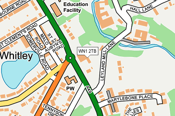
WN1 2TB lies on Wigan Lane in Wigan. WN1 2TB is located in the Wigan Central electoral ward, within the metropolitan district of Wigan and the English Parliamentary constituency of Wigan. The Sub Integrated Care Board (ICB) Location is NHS Greater Manchester ICB - 02H and the police force is Greater Manchester. This postcode has been in use since January 1992.


GetTheData
Source: OS OpenMap – Local (Ordnance Survey)
Source: OS VectorMap District (Ordnance Survey)
Licence: Open Government Licence (requires attribution)
| Easting | 358409 |
| Northing | 407470 |
| Latitude | 53.562188 |
| Longitude | -2.629384 |
GetTheData
Source: Open Postcode Geo
Licence: Open Government Licence
| Street | Wigan Lane |
| Town/City | Wigan |
| Country | England |
| Postcode District | WN1 |
➜ See where WN1 is on a map ➜ Where is Wigan? | |
GetTheData
Source: Land Registry Price Paid Data
Licence: Open Government Licence
Elevation or altitude of WN1 2TB as distance above sea level:
| Metres | Feet | |
|---|---|---|
| Elevation | 60m | 197ft |
Elevation is measured from the approximate centre of the postcode, to the nearest point on an OS contour line from OS Terrain 50, which has contour spacing of ten vertical metres.
➜ How high above sea level am I? Find the elevation of your current position using your device's GPS.
GetTheData
Source: Open Postcode Elevation
Licence: Open Government Licence
| Ward | Wigan Central |
| Constituency | Wigan |
GetTheData
Source: ONS Postcode Database
Licence: Open Government Licence
DOUGLAS BANK HOUSE, WIGAN LANE, WIGAN, WN1 2TB 1999 10 DEC £950,000 |
DOUGLAS BANK HOUSE, WIGAN LANE, WIGAN, WN1 2TB 1998 4 DEC £100,000 |
GetTheData
Source: HM Land Registry Price Paid Data
Licence: Contains HM Land Registry data © Crown copyright and database right 2025. This data is licensed under the Open Government Licence v3.0.
| Wigan Ln/Milton Gr (Wigan Ln) | Whitley | 68m |
| Wigan Ln/Woodfield Sch (Wigan Ln) | Whitley | 158m |
| Wigan Ln/Woodfield Sch (Wigan Ln) | Whitley | 168m |
| Mesnes Rd/Spencer Rd (Mesnes Rd) | Whitley | 186m |
| Wigan Ln/The Woodlands (Wigan Ln) | Marylebone | 221m |
| Wigan Wallgate Station | 1.9km |
| Wigan North Western Station | 2.1km |
| Ince (Manchester) Station | 2.8km |
GetTheData
Source: NaPTAN
Licence: Open Government Licence
GetTheData
Source: ONS Postcode Database
Licence: Open Government Licence


➜ Get more ratings from the Food Standards Agency
GetTheData
Source: Food Standards Agency
Licence: FSA terms & conditions
| Last Collection | |||
|---|---|---|---|
| Location | Mon-Fri | Sat | Distance |
| St Clements Road | 18:20 | 11:10 | 195m |
| Chauner Place | 18:20 | 11:05 | 291m |
| Mesnes Road P O | 19:00 | 12:00 | 681m |
GetTheData
Source: Dracos
Licence: Creative Commons Attribution-ShareAlike
The below table lists the International Territorial Level (ITL) codes (formerly Nomenclature of Territorial Units for Statistics (NUTS) codes) and Local Administrative Units (LAU) codes for WN1 2TB:
| ITL 1 Code | Name |
|---|---|
| TLD | North West (England) |
| ITL 2 Code | Name |
| TLD3 | Greater Manchester |
| ITL 3 Code | Name |
| TLD36 | Greater Manchester North West |
| LAU 1 Code | Name |
| E08000010 | Wigan |
GetTheData
Source: ONS Postcode Directory
Licence: Open Government Licence
The below table lists the Census Output Area (OA), Lower Layer Super Output Area (LSOA), and Middle Layer Super Output Area (MSOA) for WN1 2TB:
| Code | Name | |
|---|---|---|
| OA | E00032317 | |
| LSOA | E01006372 | Wigan 006B |
| MSOA | E02001292 | Wigan 006 |
GetTheData
Source: ONS Postcode Directory
Licence: Open Government Licence
| WN1 2NT | Wigan Lane | 117m |
| WN1 2RY | St Aubyns Road | 155m |
| WN1 2SA | Foundry Cottages | 155m |
| WN1 2PN | St Malo Road | 158m |
| WN1 2NX | Marylebone Court | 169m |
| WN1 2NS | Marylebone Place | 181m |
| WN1 2RX | Somerville Road | 210m |
| WN1 2RP | Wigan Lane | 224m |
| WN1 2PQ | Tennyson Drive | 233m |
| WN1 2PW | Spencer Road | 248m |
GetTheData
Source: Open Postcode Geo; Land Registry Price Paid Data
Licence: Open Government Licence