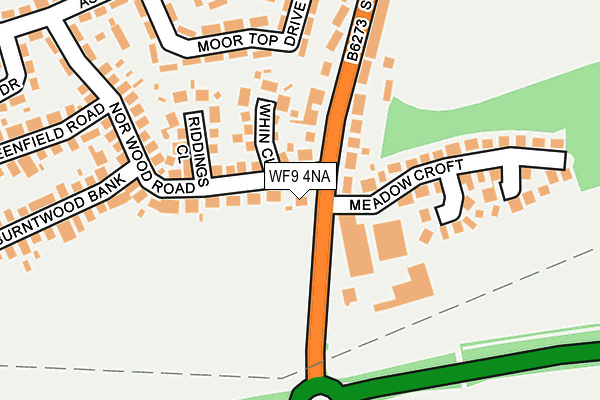
WF9 4NA is located in the Hemsworth electoral ward, within the metropolitan district of Wakefield and the English Parliamentary constituency of Hemsworth. The Sub Integrated Care Board (ICB) Location is NHS West Yorkshire ICB - 03R and the police force is West Yorkshire. This postcode has been in use since January 1980.


GetTheData
Source: OS OpenMap – Local (Ordnance Survey)
Source: OS VectorMap District (Ordnance Survey)
Licence: Open Government Licence (requires attribution)
| Easting | 442956 |
| Northing | 412195 |
| Latitude | 53.604580 |
| Longitude | -1.352305 |
GetTheData
Source: Open Postcode Geo
Licence: Open Government Licence
| Country | England |
| Postcode District | WF9 |
➜ See where WF9 is on a map ➜ Where is Hemsworth? | |
GetTheData
Source: Land Registry Price Paid Data
Licence: Open Government Licence
Elevation or altitude of WF9 4NA as distance above sea level:
| Metres | Feet | |
|---|---|---|
| Elevation | 70m | 230ft |
Elevation is measured from the approximate centre of the postcode, to the nearest point on an OS contour line from OS Terrain 50, which has contour spacing of ten vertical metres.
➜ How high above sea level am I? Find the elevation of your current position using your device's GPS.
GetTheData
Source: Open Postcode Elevation
Licence: Open Government Licence
| Ward | Hemsworth |
| Constituency | Hemsworth |
GetTheData
Source: ONS Postcode Database
Licence: Open Government Licence
| Ashfield Road Southmoor Rd (Ashfield Road) | Hemsworth | 322m |
| Ashfield Road Moor Top Dr (Ashfield Road) | Hemsworth | 339m |
| Ashfield Road Norwood Rd (Ashfield Road) | Hemsworth | 390m |
| Kirkby Rd Hague Crescent (Kirkby Road) | Hemsworth | 472m |
| Kirkby Rd Springfield Avenue (Kirkby Road) | Hemsworth | 487m |
| Moorthorpe Station | 3.3km |
| Fitzwilliam Station | 3.4km |
| South Elmsall Station | 4.6km |
GetTheData
Source: NaPTAN
Licence: Open Government Licence
| Percentage of properties with Next Generation Access | 100.0% |
| Percentage of properties with Superfast Broadband | 100.0% |
| Percentage of properties with Ultrafast Broadband | 0.0% |
| Percentage of properties with Full Fibre Broadband | 0.0% |
Superfast Broadband is between 30Mbps and 300Mbps
Ultrafast Broadband is > 300Mbps
| Percentage of properties unable to receive 2Mbps | 0.0% |
| Percentage of properties unable to receive 5Mbps | 0.0% |
| Percentage of properties unable to receive 10Mbps | 0.0% |
| Percentage of properties unable to receive 30Mbps | 0.0% |
GetTheData
Source: Ofcom
Licence: Ofcom Terms of Use (requires attribution)
GetTheData
Source: ONS Postcode Database
Licence: Open Government Licence


➜ Get more ratings from the Food Standards Agency
GetTheData
Source: Food Standards Agency
Licence: FSA terms & conditions
| Last Collection | |||
|---|---|---|---|
| Location | Mon-Fri | Sat | Distance |
| Norwood Cres/South Moor Road | 17:30 | 11:00 | 96m |
| Ashfield Road / Norwood Road | 17:30 | 11:00 | 381m |
| Kirkby Road / Kirkby Road | 17:30 | 11:00 | 490m |
GetTheData
Source: Dracos
Licence: Creative Commons Attribution-ShareAlike
The below table lists the International Territorial Level (ITL) codes (formerly Nomenclature of Territorial Units for Statistics (NUTS) codes) and Local Administrative Units (LAU) codes for WF9 4NA:
| ITL 1 Code | Name |
|---|---|
| TLE | Yorkshire and The Humber |
| ITL 2 Code | Name |
| TLE4 | West Yorkshire |
| ITL 3 Code | Name |
| TLE45 | Wakefield |
| LAU 1 Code | Name |
| E08000036 | Wakefield |
GetTheData
Source: ONS Postcode Directory
Licence: Open Government Licence
The below table lists the Census Output Area (OA), Lower Layer Super Output Area (LSOA), and Middle Layer Super Output Area (MSOA) for WF9 4NA:
| Code | Name | |
|---|---|---|
| OA | E00059456 | |
| LSOA | E01011790 | Wakefield 042C |
| MSOA | E02002479 | Wakefield 042 |
GetTheData
Source: ONS Postcode Directory
Licence: Open Government Licence
| WF9 4RE | Norwood Road | 119m |
| WF9 4RQ | Whin Close | 154m |
| WF9 4HS | Meadow Croft | 188m |
| WF9 4LZ | Southmoor Road | 206m |
| WF9 4RH | Riddings Close | 207m |
| WF9 4RF | Norwood Road | 218m |
| WF9 4SD | Moortop Drive | 265m |
| WF9 4SE | Moortop Drive | 272m |
| WF9 4SG | Penlington Close | 282m |
| WF9 4SF | Thornton Close | 292m |
GetTheData
Source: Open Postcode Geo; Land Registry Price Paid Data
Licence: Open Government Licence