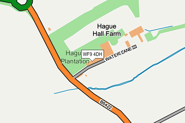
WF9 4DH is located in the South Elmsall and South Kirkby electoral ward, within the metropolitan district of Wakefield and the English Parliamentary constituency of Hemsworth. The Sub Integrated Care Board (ICB) Location is NHS West Yorkshire ICB - 03R and the police force is West Yorkshire. This postcode has been in use since January 1980.


GetTheData
Source: OS OpenMap – Local (Ordnance Survey)
Source: OS VectorMap District (Ordnance Survey)
Licence: Open Government Licence (requires attribution)
| Easting | 443870 |
| Northing | 411882 |
| Latitude | 53.601674 |
| Longitude | -1.338536 |
GetTheData
Source: Open Postcode Geo
Licence: Open Government Licence
| Country | England |
| Postcode District | WF9 |
➜ See where WF9 is on a map | |
GetTheData
Source: Land Registry Price Paid Data
Licence: Open Government Licence
Elevation or altitude of WF9 4DH as distance above sea level:
| Metres | Feet | |
|---|---|---|
| Elevation | 40m | 131ft |
Elevation is measured from the approximate centre of the postcode, to the nearest point on an OS contour line from OS Terrain 50, which has contour spacing of ten vertical metres.
➜ How high above sea level am I? Find the elevation of your current position using your device's GPS.
GetTheData
Source: Open Postcode Elevation
Licence: Open Government Licence
| Ward | South Elmsall And South Kirkby |
| Constituency | Hemsworth |
GetTheData
Source: ONS Postcode Database
Licence: Open Government Licence
| Hague Hall Farm (Hemsworth Road) | South Kirkby | 296m |
| Hague Hall Farm (Hemsworth Road) | South Kirkby | 318m |
| Kirkby Road By Pass (Hemsworth Road) | Hemsworth | 423m |
| Hemsworth Road Bridge House (Hemsworth Road) | Hemsworth | 454m |
| Kirkby Rd Hague Crescent (Kirkby Road) | Hemsworth | 735m |
| Moorthorpe Station | 2.3km |
| South Elmsall Station | 3.6km |
| Fitzwilliam Station | 4.2km |
GetTheData
Source: NaPTAN
Licence: Open Government Licence
GetTheData
Source: ONS Postcode Database
Licence: Open Government Licence


➜ Get more ratings from the Food Standards Agency
GetTheData
Source: Food Standards Agency
Licence: FSA terms & conditions
| Last Collection | |||
|---|---|---|---|
| Location | Mon-Fri | Sat | Distance |
| Kirkby Road / Kirkby Road | 17:30 | 11:00 | 701m |
| Norwood Cres/South Moor Road | 17:30 | 11:00 | 1,034m |
| Common End P.o. | 17:30 | 11:15 | 1,060m |
GetTheData
Source: Dracos
Licence: Creative Commons Attribution-ShareAlike
The below table lists the International Territorial Level (ITL) codes (formerly Nomenclature of Territorial Units for Statistics (NUTS) codes) and Local Administrative Units (LAU) codes for WF9 4DH:
| ITL 1 Code | Name |
|---|---|
| TLE | Yorkshire and The Humber |
| ITL 2 Code | Name |
| TLE4 | West Yorkshire |
| ITL 3 Code | Name |
| TLE45 | Wakefield |
| LAU 1 Code | Name |
| E08000036 | Wakefield |
GetTheData
Source: ONS Postcode Directory
Licence: Open Government Licence
The below table lists the Census Output Area (OA), Lower Layer Super Output Area (LSOA), and Middle Layer Super Output Area (MSOA) for WF9 4DH:
| Code | Name | |
|---|---|---|
| OA | E00059871 | |
| LSOA | E01011864 | Wakefield 045A |
| MSOA | E02002482 | Wakefield 045 |
GetTheData
Source: ONS Postcode Directory
Licence: Open Government Licence
| WF9 4DG | Hemsworth Road | 178m |
| WF9 4TF | Chestnut Grove | 661m |
| WF9 4DQ | Kirkbygate | 691m |
| WF9 4TB | Dale View | 693m |
| WF9 4TA | Dale View | 697m |
| WF9 4DE | Kirkby Road | 733m |
| WF9 4TQ | Elizabeth Court | 739m |
| WF9 4TH | Windsor Road | 744m |
| WF9 4DD | York Street | 762m |
| WF9 4TD | Oakwood Drive | 764m |
GetTheData
Source: Open Postcode Geo; Land Registry Price Paid Data
Licence: Open Government Licence