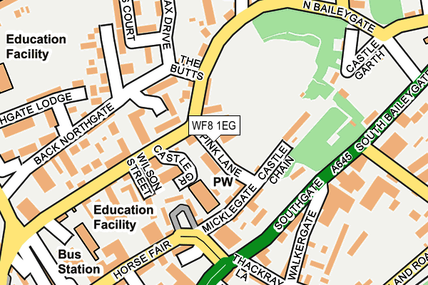
WF8 1EG lies on Spink Lane in Pontefract. WF8 1EG is located in the Pontefract North electoral ward, within the metropolitan district of Wakefield and the English Parliamentary constituency of Normanton, Pontefract and Castleford. The Sub Integrated Care Board (ICB) Location is NHS West Yorkshire ICB - 03R and the police force is West Yorkshire. This postcode has been in use since January 1980.


GetTheData
Source: OS OpenMap – Local (Ordnance Survey)
Source: OS VectorMap District (Ordnance Survey)
Licence: Open Government Licence (requires attribution)
| Easting | 445957 |
| Northing | 422262 |
| Latitude | 53.694787 |
| Longitude | -1.305471 |
GetTheData
Source: Open Postcode Geo
Licence: Open Government Licence
| Street | Spink Lane |
| Town/City | Pontefract |
| Country | England |
| Postcode District | WF8 |
➜ See where WF8 is on a map ➜ Where is Pontefract? | |
GetTheData
Source: Land Registry Price Paid Data
Licence: Open Government Licence
Elevation or altitude of WF8 1EG as distance above sea level:
| Metres | Feet | |
|---|---|---|
| Elevation | 50m | 164ft |
Elevation is measured from the approximate centre of the postcode, to the nearest point on an OS contour line from OS Terrain 50, which has contour spacing of ten vertical metres.
➜ How high above sea level am I? Find the elevation of your current position using your device's GPS.
GetTheData
Source: Open Postcode Elevation
Licence: Open Government Licence
| Ward | Pontefract North |
| Constituency | Normanton, Pontefract And Castleford |
GetTheData
Source: ONS Postcode Database
Licence: Open Government Licence
| Northgate Spink Lane (Northgate) | Pontefract | 62m |
| Northgate Spink Lane (Northgate) | Pontefract | 67m |
| South Baileygate Baghill Lane (South Baileygate) | Pontefract | 199m |
| North Baileygate Mill Dam Lane (Newroyd Road) | Pontefract | 216m |
| North Baileygate Mill Dam Lane (Newroyd Road) | Pontefract | 221m |
| Pontefract Baghill Station | 0.4km |
| Pontefract Monkhill Station | 0.5km |
| Pontefract Tanshelf Station | 0.9km |
GetTheData
Source: NaPTAN
Licence: Open Government Licence
| Percentage of properties with Next Generation Access | 100.0% |
| Percentage of properties with Superfast Broadband | 100.0% |
| Percentage of properties with Ultrafast Broadband | 0.0% |
| Percentage of properties with Full Fibre Broadband | 0.0% |
Superfast Broadband is between 30Mbps and 300Mbps
Ultrafast Broadband is > 300Mbps
| Percentage of properties unable to receive 2Mbps | 0.0% |
| Percentage of properties unable to receive 5Mbps | 0.0% |
| Percentage of properties unable to receive 10Mbps | 0.0% |
| Percentage of properties unable to receive 30Mbps | 0.0% |
GetTheData
Source: Ofcom
Licence: Ofcom Terms of Use (requires attribution)
GetTheData
Source: ONS Postcode Database
Licence: Open Government Licence


➜ Get more ratings from the Food Standards Agency
GetTheData
Source: Food Standards Agency
Licence: FSA terms & conditions
| Last Collection | |||
|---|---|---|---|
| Location | Mon-Fri | Sat | Distance |
| Pontefract Delivery Office | 18:30 | 11:30 | 282m |
| Pontefract Delivery Office | 18:30 | 12:00 | 283m |
| Old Church | 17:30 | 11:30 | 562m |
GetTheData
Source: Dracos
Licence: Creative Commons Attribution-ShareAlike
The below table lists the International Territorial Level (ITL) codes (formerly Nomenclature of Territorial Units for Statistics (NUTS) codes) and Local Administrative Units (LAU) codes for WF8 1EG:
| ITL 1 Code | Name |
|---|---|
| TLE | Yorkshire and The Humber |
| ITL 2 Code | Name |
| TLE4 | West Yorkshire |
| ITL 3 Code | Name |
| TLE45 | Wakefield |
| LAU 1 Code | Name |
| E08000036 | Wakefield |
GetTheData
Source: ONS Postcode Directory
Licence: Open Government Licence
The below table lists the Census Output Area (OA), Lower Layer Super Output Area (LSOA), and Middle Layer Super Output Area (MSOA) for WF8 1EG:
| Code | Name | |
|---|---|---|
| OA | E00059686 | |
| LSOA | E01011838 | Wakefield 015C |
| MSOA | E02002452 | Wakefield 015 |
GetTheData
Source: ONS Postcode Directory
Licence: Open Government Licence
| WF8 1EH | Castle Moat | 46m |
| WF8 1EJ | Northgate | 69m |
| WF8 1GW | Castle Grove | 81m |
| WF8 1HP | The Maltings | 85m |
| WF8 1QG | Micklegate | 85m |
| WF8 1EW | Northgate | 87m |
| WF8 1QH | Castle Chain | 87m |
| WF8 1HL | Wilson Street | 124m |
| WF8 1EP | Castle Mews | 126m |
| WF8 1HN | North Ives | 132m |
GetTheData
Source: Open Postcode Geo; Land Registry Price Paid Data
Licence: Open Government Licence