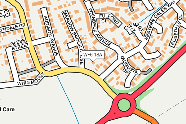
WF6 1SA lies on Church Lane in Normanton. WF6 1SA is located in the Normanton electoral ward, within the metropolitan district of Wakefield and the English Parliamentary constituency of Normanton, Pontefract and Castleford. The Sub Integrated Care Board (ICB) Location is NHS West Yorkshire ICB - 03R and the police force is West Yorkshire. This postcode has been in use since December 1999.


GetTheData
Source: OS OpenMap – Local (Ordnance Survey)
Source: OS VectorMap District (Ordnance Survey)
Licence: Open Government Licence (requires attribution)
| Easting | 439506 |
| Northing | 421927 |
| Latitude | 53.692302 |
| Longitude | -1.403205 |
GetTheData
Source: Open Postcode Geo
Licence: Open Government Licence
| Street | Church Lane |
| Town/City | Normanton |
| Country | England |
| Postcode District | WF6 |
➜ See where WF6 is on a map ➜ Where is Normanton? | |
GetTheData
Source: Land Registry Price Paid Data
Licence: Open Government Licence
Elevation or altitude of WF6 1SA as distance above sea level:
| Metres | Feet | |
|---|---|---|
| Elevation | 30m | 98ft |
Elevation is measured from the approximate centre of the postcode, to the nearest point on an OS contour line from OS Terrain 50, which has contour spacing of ten vertical metres.
➜ How high above sea level am I? Find the elevation of your current position using your device's GPS.
GetTheData
Source: Open Postcode Elevation
Licence: Open Government Licence
| Ward | Normanton |
| Constituency | Normanton, Pontefract And Castleford |
GetTheData
Source: ONS Postcode Database
Licence: Open Government Licence
LE FORT, CHURCH LANE, NORMANTON, WF6 1SA 1999 26 FEB £105,000 |
GetTheData
Source: HM Land Registry Price Paid Data
Licence: Contains HM Land Registry data © Crown copyright and database right 2025. This data is licensed under the Open Government Licence v3.0.
| Church Lane Western Gales Wy (Church Lane) | Normanton | 19m |
| Snydale Rd Addison Avenue (Snydale Road) | Normanton | 124m |
| Snydale Rd Addison Avenue (Snydale Road) | Normanton | 124m |
| Snydale Rd Addison Avenue (Snydale Road) | Normanton | 195m |
| Syndale Rd Glebe Street (Snydale Road) | Normanton | 224m |
| Normanton Station | 1.6km |
| Streethouse Station | 1.8km |
| Featherstone Station | 3.3km |
GetTheData
Source: NaPTAN
Licence: Open Government Licence
| Percentage of properties with Next Generation Access | 100.0% |
| Percentage of properties with Superfast Broadband | 100.0% |
| Percentage of properties with Ultrafast Broadband | 0.0% |
| Percentage of properties with Full Fibre Broadband | 0.0% |
Superfast Broadband is between 30Mbps and 300Mbps
Ultrafast Broadband is > 300Mbps
| Percentage of properties unable to receive 2Mbps | 0.0% |
| Percentage of properties unable to receive 5Mbps | 0.0% |
| Percentage of properties unable to receive 10Mbps | 0.0% |
| Percentage of properties unable to receive 30Mbps | 0.0% |
GetTheData
Source: Ofcom
Licence: Ofcom Terms of Use (requires attribution)
GetTheData
Source: ONS Postcode Database
Licence: Open Government Licence


➜ Get more ratings from the Food Standards Agency
GetTheData
Source: Food Standards Agency
Licence: FSA terms & conditions
| Last Collection | |||
|---|---|---|---|
| Location | Mon-Fri | Sat | Distance |
| Western Gales Way | 17:30 | 11:15 | 69m |
| Snydale Road | 17:30 | 11:15 | 267m |
| Kingston Drive / Sunningdales | 17:30 | 11:00 | 352m |
GetTheData
Source: Dracos
Licence: Creative Commons Attribution-ShareAlike
The below table lists the International Territorial Level (ITL) codes (formerly Nomenclature of Territorial Units for Statistics (NUTS) codes) and Local Administrative Units (LAU) codes for WF6 1SA:
| ITL 1 Code | Name |
|---|---|
| TLE | Yorkshire and The Humber |
| ITL 2 Code | Name |
| TLE4 | West Yorkshire |
| ITL 3 Code | Name |
| TLE45 | Wakefield |
| LAU 1 Code | Name |
| E08000036 | Wakefield |
GetTheData
Source: ONS Postcode Directory
Licence: Open Government Licence
The below table lists the Census Output Area (OA), Lower Layer Super Output Area (LSOA), and Middle Layer Super Output Area (MSOA) for WF6 1SA:
| Code | Name | |
|---|---|---|
| OA | E00059413 | |
| LSOA | E01011775 | Wakefield 024A |
| MSOA | E02002461 | Wakefield 024 |
GetTheData
Source: ONS Postcode Directory
Licence: Open Government Licence
| WF6 1TQ | Meadow Brook Court | 88m |
| WF6 1JA | Ganton Court | 112m |
| WF6 1UB | Augusta Drive | 123m |
| WF6 1TG | Meadow Brook Close | 129m |
| WF6 1UA | Western Gales Way | 138m |
| WF6 1TH | Meadow Brook Green | 143m |
| WF6 1PF | Addison Avenue | 157m |
| WF6 1UF | Clement Close | 160m |
| WF6 1PE | Snydale Road | 171m |
| WF6 1JB | Fulford Close | 171m |
GetTheData
Source: Open Postcode Geo; Land Registry Price Paid Data
Licence: Open Government Licence