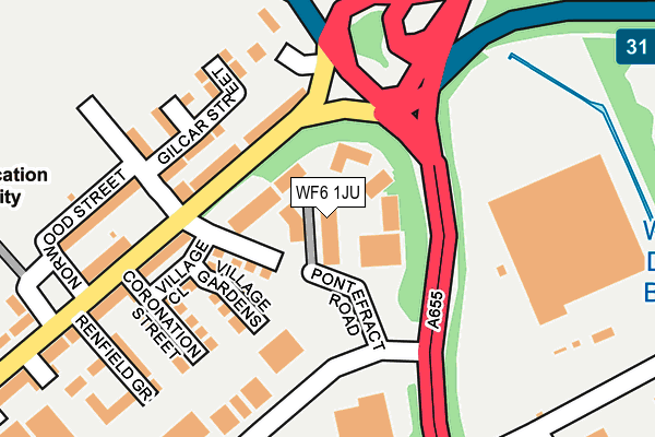
WF6 1JU is located in the Normanton electoral ward, within the metropolitan district of Wakefield and the English Parliamentary constituency of Normanton, Pontefract and Castleford. The Sub Integrated Care Board (ICB) Location is NHS West Yorkshire ICB - 03R and the police force is West Yorkshire. This postcode has been in use since May 2009.


GetTheData
Source: OS OpenMap – Local (Ordnance Survey)
Source: OS VectorMap District (Ordnance Survey)
Licence: Open Government Licence (requires attribution)
| Easting | 439816 |
| Northing | 423515 |
| Latitude | 53.706551 |
| Longitude | -1.398308 |
GetTheData
Source: Open Postcode Geo
Licence: Open Government Licence
| Country | England |
| Postcode District | WF6 |
➜ See where WF6 is on a map ➜ Where is Normanton? | |
GetTheData
Source: Land Registry Price Paid Data
Licence: Open Government Licence
Elevation or altitude of WF6 1JU as distance above sea level:
| Metres | Feet | |
|---|---|---|
| Elevation | 20m | 66ft |
Elevation is measured from the approximate centre of the postcode, to the nearest point on an OS contour line from OS Terrain 50, which has contour spacing of ten vertical metres.
➜ How high above sea level am I? Find the elevation of your current position using your device's GPS.
GetTheData
Source: Open Postcode Elevation
Licence: Open Government Licence
| Ward | Normanton |
| Constituency | Normanton, Pontefract And Castleford |
GetTheData
Source: ONS Postcode Database
Licence: Open Government Licence
| Castleford Rd Mill Lane (Castleford Road) | Whitwood | 118m |
| Castleford Rd Mill Lane (Castleford Road) | Whitwood | 157m |
| Castleford Road Benson Ln (Castleford Road) | Normanton | 370m |
| Pontefract Road | Whitwood | 412m |
| Castleford Road Benson Ln (Castleford Road) | Normanton | 456m |
| Normanton Station | 1.8km |
| Streethouse Station | 3.4km |
| Castleford Station | 3.5km |
GetTheData
Source: NaPTAN
Licence: Open Government Licence
GetTheData
Source: ONS Postcode Database
Licence: Open Government Licence


➜ Get more ratings from the Food Standards Agency
GetTheData
Source: Food Standards Agency
Licence: FSA terms & conditions
| Last Collection | |||
|---|---|---|---|
| Location | Mon-Fri | Sat | Distance |
| Normanton Industrial Estate | 111m | ||
| The Village | 17:30 | 11:00 | 173m |
| Ripley Drive | 18:30 | 11:00 | 306m |
GetTheData
Source: Dracos
Licence: Creative Commons Attribution-ShareAlike
The below table lists the International Territorial Level (ITL) codes (formerly Nomenclature of Territorial Units for Statistics (NUTS) codes) and Local Administrative Units (LAU) codes for WF6 1JU:
| ITL 1 Code | Name |
|---|---|
| TLE | Yorkshire and The Humber |
| ITL 2 Code | Name |
| TLE4 | West Yorkshire |
| ITL 3 Code | Name |
| TLE45 | Wakefield |
| LAU 1 Code | Name |
| E08000036 | Wakefield |
GetTheData
Source: ONS Postcode Directory
Licence: Open Government Licence
The below table lists the Census Output Area (OA), Lower Layer Super Output Area (LSOA), and Middle Layer Super Output Area (MSOA) for WF6 1JU:
| Code | Name | |
|---|---|---|
| OA | E00059318 | |
| LSOA | E01011758 | Wakefield 013A |
| MSOA | E02002450 | Wakefield 013 |
GetTheData
Source: ONS Postcode Directory
Licence: Open Government Licence
| WF6 1RQ | Castleford Road | 102m |
| WF6 1RD | Gilcar Street | 130m |
| WF6 1RP | Gilcar Villas | 173m |
| WF6 1RA | Mill Lane | 188m |
| WF6 1RG | Coronation Street | 188m |
| WF6 1RB | Norwood Street | 211m |
| WF6 1QZ | Renfield Grove | 221m |
| WF6 1QY | Castleford Road | 260m |
| WF6 1RJ | Waterford Place | 274m |
| WF6 1QF | School Court | 300m |
GetTheData
Source: Open Postcode Geo; Land Registry Price Paid Data
Licence: Open Government Licence