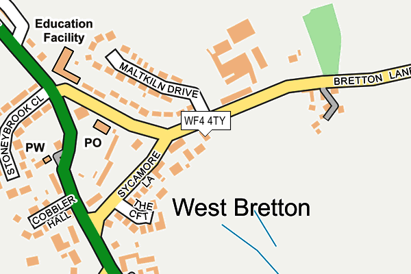
WF4 4TY is located in the Wakefield Rural electoral ward, within the metropolitan district of Wakefield and the English Parliamentary constituency of Wakefield. The Sub Integrated Care Board (ICB) Location is NHS West Yorkshire ICB - 03R and the police force is West Yorkshire. This postcode has been in use since April 2017.


GetTheData
Source: OS OpenMap – Local (Ordnance Survey)
Source: OS VectorMap District (Ordnance Survey)
Licence: Open Government Licence (requires attribution)
| Easting | 428870 |
| Northing | 413765 |
| Latitude | 53.619653 |
| Longitude | -1.565027 |
GetTheData
Source: Open Postcode Geo
Licence: Open Government Licence
| Country | England |
| Postcode District | WF4 |
| ➜ WF4 open data dashboard ➜ See where WF4 is on a map ➜ Where is West Bretton? | |
GetTheData
Source: Land Registry Price Paid Data
Licence: Open Government Licence
| Ward | Wakefield Rural |
| Constituency | Wakefield |
GetTheData
Source: ONS Postcode Database
Licence: Open Government Licence
2, HOYLAND MANOR, BRETTON, WAKEFIELD, WF4 4TY 2018 19 JUL £675,000 |
1, HOYLAND MANOR, BRETTON, WAKEFIELD, WF4 4TY 2017 21 MAR £645,000 |
2016 7 JUL £215,000 |
GetTheData
Source: HM Land Registry Price Paid Data
Licence: Contains HM Land Registry data © Crown copyright and database right 2024. This data is licensed under the Open Government Licence v3.0.
| September 2023 | Burglary | On or near The Croft | 137m |
| September 2023 | Burglary | On or near The Croft | 137m |
| April 2023 | Anti-social behaviour | On or near The Croft | 137m |
| ➜ Get more crime data in our Crime section | |||
GetTheData
Source: data.police.uk
Licence: Open Government Licence
| Sycamore Lane Bretton Ln (Sycamore Lane) | West Bretton | 78m |
| Sycamore Lane The Croft (Sycamore Lane) | West Bretton | 87m |
| Bretton Lane Post Office (Bretton Lane) | West Bretton | 179m |
| Bretton Lane Post Office (Bretton Lane) | West Bretton | 184m |
| Huddersfield Rd Sycamore Lane (Huddersfield Road Sycamore Lane) | West Bretton | 200m |
| Darton Station | 4.1km |
GetTheData
Source: NaPTAN
Licence: Open Government Licence
| Percentage of properties with Next Generation Access | 100.0% |
| Percentage of properties with Superfast Broadband | 100.0% |
| Percentage of properties with Ultrafast Broadband | 0.0% |
| Percentage of properties with Full Fibre Broadband | 0.0% |
Superfast Broadband is between 30Mbps and 300Mbps
Ultrafast Broadband is > 300Mbps
| Percentage of properties unable to receive 2Mbps | 0.0% |
| Percentage of properties unable to receive 5Mbps | 0.0% |
| Percentage of properties unable to receive 10Mbps | 0.0% |
| Percentage of properties unable to receive 30Mbps | 0.0% |
GetTheData
Source: Ofcom
Licence: Ofcom Terms of Use (requires attribution)
GetTheData
Source: ONS Postcode Database
Licence: Open Government Licence


➜ Get more ratings from the Food Standards Agency
GetTheData
Source: Food Standards Agency
Licence: FSA terms & conditions
| Last Collection | |||
|---|---|---|---|
| Location | Mon-Fri | Sat | Distance |
| Barnsley Road | 16:45 | 11:30 | 200m |
| Woolley Service Station (N) | 16:15 | 11:45 | 1,035m |
| Wooley Service Station (S) | 16:15 | 11:45 | 1,309m |
GetTheData
Source: Dracos
Licence: Creative Commons Attribution-ShareAlike
| Facility | Distance |
|---|---|
| West Bretton Cricket Club Park Lane, Bretton, Wakefield Grass Pitches | 432m |
| Bretton Hall Tigers (Closed) Bretton Hall, Bretton, Wakefield Grass Pitches | 1km |
| Hall Green United Fc Painthorpe Lane, Hall Green, Wakefield Grass Pitches | 3.1km |
GetTheData
Source: Active Places
Licence: Open Government Licence
| School | Phase of Education | Distance |
|---|---|---|
| West Bretton Junior and Infant School Bretton Lane, West Bretton, Wakefield, WF4 4LB | Primary | 209m |
| Denby Grange School Off Stocksmoor Rd, Midgley, Wakefield, WF4 4JG | Not applicable | 2.4km |
| Crigglestone Mackie Hill Junior and Infant School Painthorpe Lane, Crigglestone, Wakefield, WF4 3HW | Primary | 2.9km |
GetTheData
Source: Edubase
Licence: Open Government Licence
The below table lists the International Territorial Level (ITL) codes (formerly Nomenclature of Territorial Units for Statistics (NUTS) codes) and Local Administrative Units (LAU) codes for WF4 4TY:
| ITL 1 Code | Name |
|---|---|
| TLE | Yorkshire and The Humber |
| ITL 2 Code | Name |
| TLE4 | West Yorkshire |
| ITL 3 Code | Name |
| TLE45 | Wakefield |
| LAU 1 Code | Name |
| E08000036 | Wakefield |
GetTheData
Source: ONS Postcode Directory
Licence: Open Government Licence
The below table lists the Census Output Area (OA), Lower Layer Super Output Area (LSOA), and Middle Layer Super Output Area (MSOA) for WF4 4TY:
| Code | Name | |
|---|---|---|
| OA | E00060202 | |
| LSOA | E01011935 | Wakefield 038A |
| MSOA | E02002475 | Wakefield 038 |
GetTheData
Source: ONS Postcode Directory
Licence: Open Government Licence
| WF4 4JZ | Sycamore Lane | 104m |
| WF4 4LB | Bretton Lane | 118m |
| WF4 4LA | Bretton Lane | 128m |
| WF4 4LH | The Croft | 137m |
| WF4 4LD | Maltkiln Drive | 141m |
| WF4 4JR | Sycamore Lane | 151m |
| WF4 4LE | Bretton Lane | 179m |
| WF4 4JY | Huddersfield Road | 185m |
| WF4 4UG | Innfold Farm | 210m |
| WF4 4JP | Huddersfield Road | 216m |
GetTheData
Source: Open Postcode Geo; Land Registry Price Paid Data
Licence: Open Government Licence