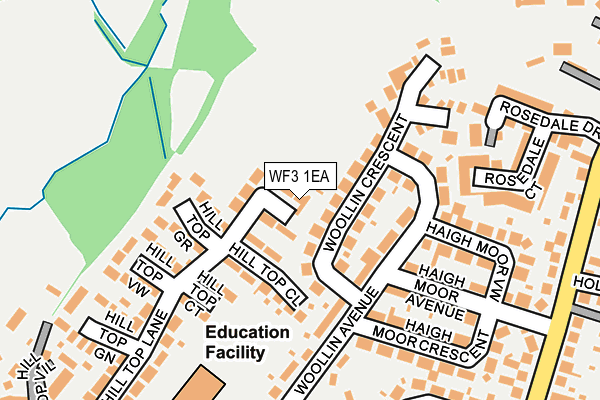
WF3 1EA lies on Hill Top Gardens in Tingley, Wakefield. WF3 1EA is located in the Ardsley & Robin Hood electoral ward, within the metropolitan district of Leeds and the English Parliamentary constituency of Morley and Outwood. The Sub Integrated Care Board (ICB) Location is NHS West Yorkshire ICB - 15F and the police force is West Yorkshire. This postcode has been in use since July 1990.


GetTheData
Source: OS OpenMap – Local (Ordnance Survey)
Source: OS VectorMap District (Ordnance Survey)
Licence: Open Government Licence (requires attribution)
| Easting | 428144 |
| Northing | 424709 |
| Latitude | 53.718040 |
| Longitude | -1.575011 |
GetTheData
Source: Open Postcode Geo
Licence: Open Government Licence
| Street | Hill Top Gardens |
| Locality | Tingley |
| Town/City | Wakefield |
| Country | England |
| Postcode District | WF3 |
➜ See where WF3 is on a map ➜ Where is West Ardsley? | |
GetTheData
Source: Land Registry Price Paid Data
Licence: Open Government Licence
Elevation or altitude of WF3 1EA as distance above sea level:
| Metres | Feet | |
|---|---|---|
| Elevation | 120m | 394ft |
Elevation is measured from the approximate centre of the postcode, to the nearest point on an OS contour line from OS Terrain 50, which has contour spacing of ten vertical metres.
➜ How high above sea level am I? Find the elevation of your current position using your device's GPS.
GetTheData
Source: Open Postcode Elevation
Licence: Open Government Licence
| Ward | Ardsley & Robin Hood |
| Constituency | Morley And Outwood |
GetTheData
Source: ONS Postcode Database
Licence: Open Government Licence
| Haigh Moor Rd Holly Court (Haigh Moor Road) | Westerton | 277m |
| Haigh Moor Rd Holly Court (Haigh Moor Road) | Westerton | 286m |
| Boyle Hall Farm (Haigh Moor Road) | Westerton | 352m |
| Boyle Hall Farm (Haigh Moor Road) | Westerton | 358m |
| Batley Road Woollin Ave (Batley Road) | Westerton | 363m |
| Batley Station | 3.3km |
| Morley Station | 3.7km |
| Outwood Station | 4.3km |
GetTheData
Source: NaPTAN
Licence: Open Government Licence
| Percentage of properties with Next Generation Access | 100.0% |
| Percentage of properties with Superfast Broadband | 100.0% |
| Percentage of properties with Ultrafast Broadband | 0.0% |
| Percentage of properties with Full Fibre Broadband | 0.0% |
Superfast Broadband is between 30Mbps and 300Mbps
Ultrafast Broadband is > 300Mbps
| Percentage of properties unable to receive 2Mbps | 0.0% |
| Percentage of properties unable to receive 5Mbps | 0.0% |
| Percentage of properties unable to receive 10Mbps | 0.0% |
| Percentage of properties unable to receive 30Mbps | 0.0% |
GetTheData
Source: Ofcom
Licence: Ofcom Terms of Use (requires attribution)
GetTheData
Source: ONS Postcode Database
Licence: Open Government Licence


➜ Get more ratings from the Food Standards Agency
GetTheData
Source: Food Standards Agency
Licence: FSA terms & conditions
| Last Collection | |||
|---|---|---|---|
| Location | Mon-Fri | Sat | Distance |
| Haigh Moor Avenue | 16:45 | 12:45 | 279m |
| West Ardsley | 16:45 | 12:45 | 345m |
| Westerton Road | 16:45 | 12:30 | 650m |
GetTheData
Source: Dracos
Licence: Creative Commons Attribution-ShareAlike
The below table lists the International Territorial Level (ITL) codes (formerly Nomenclature of Territorial Units for Statistics (NUTS) codes) and Local Administrative Units (LAU) codes for WF3 1EA:
| ITL 1 Code | Name |
|---|---|
| TLE | Yorkshire and The Humber |
| ITL 2 Code | Name |
| TLE4 | West Yorkshire |
| ITL 3 Code | Name |
| TLE42 | Leeds |
| LAU 1 Code | Name |
| E08000035 | Leeds |
GetTheData
Source: ONS Postcode Directory
Licence: Open Government Licence
The below table lists the Census Output Area (OA), Lower Layer Super Output Area (LSOA), and Middle Layer Super Output Area (MSOA) for WF3 1EA:
| Code | Name | |
|---|---|---|
| OA | E00058164 | |
| LSOA | E01011536 | Leeds 108B |
| MSOA | E02002437 | Leeds 108 |
GetTheData
Source: ONS Postcode Directory
Licence: Open Government Licence
| WF3 1ET | Woollin Crescent | 82m |
| WF3 1HP | Hill Top Grove | 92m |
| WF3 1DZ | Hill Top Close | 92m |
| WF3 1EP | Woollin Avenue | 106m |
| WF3 1DY | Hill Top Court | 122m |
| WF3 1ES | Haigh Moor Avenue | 166m |
| WF3 1EW | Haigh Moor View | 179m |
| WF3 1EY | Haigh Moor Crescent | 190m |
| WF3 1HR | Hill Top View | 191m |
| WF3 1EU | Woollin Avenue | 198m |
GetTheData
Source: Open Postcode Geo; Land Registry Price Paid Data
Licence: Open Government Licence