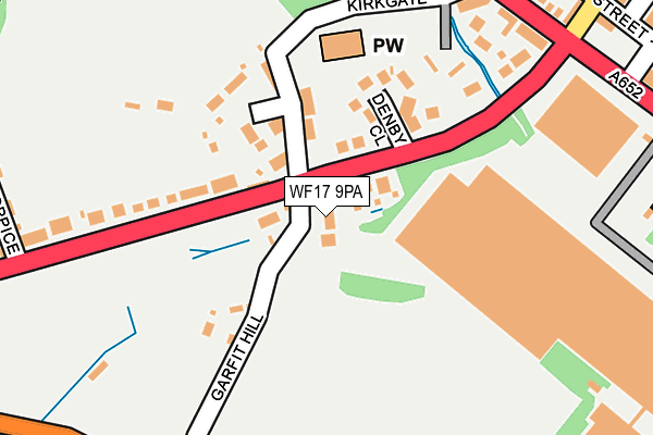
WF17 9PA is located in the Birstall and Birkenshaw electoral ward, within the metropolitan district of Kirklees and the English Parliamentary constituency of Batley and Spen. The Sub Integrated Care Board (ICB) Location is NHS West Yorkshire ICB - X2C4Y and the police force is West Yorkshire. This postcode has been in use since January 1980.


GetTheData
Source: OS OpenMap – Local (Ordnance Survey)
Source: OS VectorMap District (Ordnance Survey)
Licence: Open Government Licence (requires attribution)
| Easting | 421844 |
| Northing | 426019 |
| Latitude | 53.730114 |
| Longitude | -1.670381 |
GetTheData
Source: Open Postcode Geo
Licence: Open Government Licence
| Country | England |
| Postcode District | WF17 |
➜ See where WF17 is on a map ➜ Where is Batley? | |
GetTheData
Source: Land Registry Price Paid Data
Licence: Open Government Licence
Elevation or altitude of WF17 9PA as distance above sea level:
| Metres | Feet | |
|---|---|---|
| Elevation | 100m | 328ft |
Elevation is measured from the approximate centre of the postcode, to the nearest point on an OS contour line from OS Terrain 50, which has contour spacing of ten vertical metres.
➜ How high above sea level am I? Find the elevation of your current position using your device's GPS.
GetTheData
Source: Open Postcode Elevation
Licence: Open Government Licence
| Ward | Birstall And Birkenshaw |
| Constituency | Batley And Spen |
GetTheData
Source: ONS Postcode Database
Licence: Open Government Licence
2, GARFIT HILL, BIRSTALL, BATLEY, WF17 9PA 2021 13 AUG £300,000 |
GetTheData
Source: HM Land Registry Price Paid Data
Licence: Contains HM Land Registry data © Crown copyright and database right 2025. This data is licensed under the Open Government Licence v3.0.
| Church Lane Garfit Hill (Church Lane) | Birstall | 50m |
| Church Lane Garfit Hill (Church Lane) | Birstall | 88m |
| Church Lane Bradford Rd (Church Lane) | Birstall | 202m |
| Church Lane Bradford Rd (Church Lane) | Birstall | 224m |
| Church Lane The Coppice (Church Lane) | Birstall | 233m |
| Batley Station | 3.9km |
| Dewsbury Station | 4.9km |
GetTheData
Source: NaPTAN
Licence: Open Government Licence
| Percentage of properties with Next Generation Access | 100.0% |
| Percentage of properties with Superfast Broadband | 100.0% |
| Percentage of properties with Ultrafast Broadband | 0.0% |
| Percentage of properties with Full Fibre Broadband | 0.0% |
Superfast Broadband is between 30Mbps and 300Mbps
Ultrafast Broadband is > 300Mbps
| Percentage of properties unable to receive 2Mbps | 0.0% |
| Percentage of properties unable to receive 5Mbps | 0.0% |
| Percentage of properties unable to receive 10Mbps | 0.0% |
| Percentage of properties unable to receive 30Mbps | 0.0% |
GetTheData
Source: Ofcom
Licence: Ofcom Terms of Use (requires attribution)
GetTheData
Source: ONS Postcode Database
Licence: Open Government Licence


➜ Get more ratings from the Food Standards Agency
GetTheData
Source: Food Standards Agency
Licence: FSA terms & conditions
| Last Collection | |||
|---|---|---|---|
| Location | Mon-Fri | Sat | Distance |
| Church Lane/Kirkgate | 18:00 | 10:45 | 53m |
| Kirkgate / Bradford Road | 18:00 | 10:45 | 278m |
| Opp 924 Bradford Road | 18:00 | 10:45 | 390m |
GetTheData
Source: Dracos
Licence: Creative Commons Attribution-ShareAlike
The below table lists the International Territorial Level (ITL) codes (formerly Nomenclature of Territorial Units for Statistics (NUTS) codes) and Local Administrative Units (LAU) codes for WF17 9PA:
| ITL 1 Code | Name |
|---|---|
| TLE | Yorkshire and The Humber |
| ITL 2 Code | Name |
| TLE4 | West Yorkshire |
| ITL 3 Code | Name |
| TLE44 | Calderdale and Kirklees |
| LAU 1 Code | Name |
| E08000034 | Kirklees |
GetTheData
Source: ONS Postcode Directory
Licence: Open Government Licence
The below table lists the Census Output Area (OA), Lower Layer Super Output Area (LSOA), and Middle Layer Super Output Area (MSOA) for WF17 9PA:
| Code | Name | |
|---|---|---|
| OA | E00055679 | |
| LSOA | E01011048 | Kirklees 002A |
| MSOA | E02002272 | Kirklees 002 |
GetTheData
Source: ONS Postcode Directory
Licence: Open Government Licence
| WF17 9NX | Church Lane | 92m |
| WF17 9PS | Church Meadows | 100m |
| WF17 9PB | Kirkgate | 120m |
| WF17 9NY | Denby Close | 125m |
| BD19 4QR | Garfit Hill | 140m |
| WF17 9PW | St Peters Close | 171m |
| WF17 9NU | Bradford Road | 246m |
| WF17 9PE | Bradford Road | 286m |
| WF17 9PD | Bradford Road | 292m |
| WF17 9HE | Kirkgate | 297m |
GetTheData
Source: Open Postcode Geo; Land Registry Price Paid Data
Licence: Open Government Licence