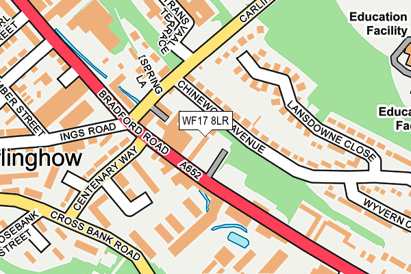
WF17 8LR lies on Hopewell Street in Batley. WF17 8LR is located in the Batley East electoral ward, within the metropolitan district of Kirklees and the English Parliamentary constituency of Batley and Spen. The Sub Integrated Care Board (ICB) Location is NHS West Yorkshire ICB - X2C4Y and the police force is West Yorkshire. This postcode has been in use since January 1980.


GetTheData
Source: OS OpenMap – Local (Ordnance Survey)
Source: OS VectorMap District (Ordnance Survey)
Licence: Open Government Licence (requires attribution)
| Easting | 423786 |
| Northing | 424882 |
| Latitude | 53.719810 |
| Longitude | -1.641034 |
GetTheData
Source: Open Postcode Geo
Licence: Open Government Licence
| Street | Hopewell Street |
| Town/City | Batley |
| Country | England |
| Postcode District | WF17 |
➜ See where WF17 is on a map ➜ Where is Batley? | |
GetTheData
Source: Land Registry Price Paid Data
Licence: Open Government Licence
Elevation or altitude of WF17 8LR as distance above sea level:
| Metres | Feet | |
|---|---|---|
| Elevation | 70m | 230ft |
Elevation is measured from the approximate centre of the postcode, to the nearest point on an OS contour line from OS Terrain 50, which has contour spacing of ten vertical metres.
➜ How high above sea level am I? Find the elevation of your current position using your device's GPS.
GetTheData
Source: Open Postcode Elevation
Licence: Open Government Licence
| Ward | Batley East |
| Constituency | Batley And Spen |
GetTheData
Source: ONS Postcode Database
Licence: Open Government Licence
| Chinewood Avenue Carlinghow Hill (Chinewood Avenue) | Upper Batley | 44m |
| Chinewood Avenue Carlinghow Hill (Chinewood Avenue) | Upper Batley | 55m |
| Carlinghow Hill Transvaal Terrace (Carlinghow Hill) | Upper Batley | 108m |
| Victoria Mills (Bradford Road) | Batley | 116m |
| Carlinghow Hill Transvaal Terrace (Carlinghow Hill) | Upper Batley | 138m |
| Batley Station | 1.6km |
| Dewsbury Station | 3.1km |
| Morley Station | 4.7km |
GetTheData
Source: NaPTAN
Licence: Open Government Licence
| Percentage of properties with Next Generation Access | 100.0% |
| Percentage of properties with Superfast Broadband | 100.0% |
| Percentage of properties with Ultrafast Broadband | 0.0% |
| Percentage of properties with Full Fibre Broadband | 0.0% |
Superfast Broadband is between 30Mbps and 300Mbps
Ultrafast Broadband is > 300Mbps
| Percentage of properties unable to receive 2Mbps | 0.0% |
| Percentage of properties unable to receive 5Mbps | 0.0% |
| Percentage of properties unable to receive 10Mbps | 0.0% |
| Percentage of properties unable to receive 30Mbps | 0.0% |
GetTheData
Source: Ofcom
Licence: Ofcom Terms of Use (requires attribution)
GetTheData
Source: ONS Postcode Database
Licence: Open Government Licence


➜ Get more ratings from the Food Standards Agency
GetTheData
Source: Food Standards Agency
Licence: FSA terms & conditions
| Last Collection | |||
|---|---|---|---|
| Location | Mon-Fri | Sat | Distance |
| 55 Cross Bank Road | 17:45 | 12:00 | 221m |
| Chinewood Ave/Landsdowne Close | 18:00 | 11:15 | 246m |
| Westbrook | 18:00 | 11:30 | 258m |
GetTheData
Source: Dracos
Licence: Creative Commons Attribution-ShareAlike
The below table lists the International Territorial Level (ITL) codes (formerly Nomenclature of Territorial Units for Statistics (NUTS) codes) and Local Administrative Units (LAU) codes for WF17 8LR:
| ITL 1 Code | Name |
|---|---|
| TLE | Yorkshire and The Humber |
| ITL 2 Code | Name |
| TLE4 | West Yorkshire |
| ITL 3 Code | Name |
| TLE44 | Calderdale and Kirklees |
| LAU 1 Code | Name |
| E08000034 | Kirklees |
GetTheData
Source: ONS Postcode Directory
Licence: Open Government Licence
The below table lists the Census Output Area (OA), Lower Layer Super Output Area (LSOA), and Middle Layer Super Output Area (MSOA) for WF17 8LR:
| Code | Name | |
|---|---|---|
| OA | E00055619 | |
| LSOA | E01011028 | Kirklees 006B |
| MSOA | E02002276 | Kirklees 006 |
GetTheData
Source: ONS Postcode Directory
Licence: Open Government Licence
| WF17 8LS | Carlinghow Hill | 88m |
| WF17 0HA | Chinewood Avenue | 120m |
| WF17 0EZ | Lansdowne Close | 122m |
| WF17 8LY | Centenary Way | 137m |
| WF17 8PL | Cross Bank Road | 192m |
| WF17 0AA | Transvaal Terrace | 194m |
| WF17 8LJ | Westbrook Terrace | 204m |
| WF17 8LH | Sandyfield Terrace | 213m |
| WF17 8HA | Bradford Road | 226m |
| WF17 8PN | Cross Bank Road | 255m |
GetTheData
Source: Open Postcode Geo; Land Registry Price Paid Data
Licence: Open Government Licence