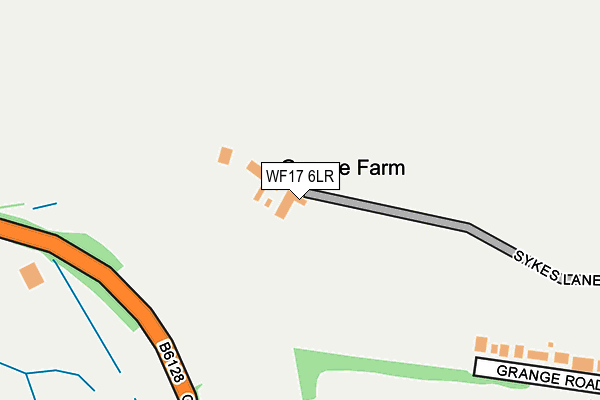
WF17 6LR is located in the Batley East electoral ward, within the metropolitan district of Kirklees and the English Parliamentary constituency of Batley and Spen. The Sub Integrated Care Board (ICB) Location is NHS West Yorkshire ICB - X2C4Y and the police force is West Yorkshire. This postcode has been in use since January 1980.


GetTheData
Source: OS OpenMap – Local (Ordnance Survey)
Source: OS VectorMap District (Ordnance Survey)
Licence: Open Government Licence (requires attribution)
| Easting | 426180 |
| Northing | 423668 |
| Latitude | 53.708800 |
| Longitude | -1.604862 |
GetTheData
Source: Open Postcode Geo
Licence: Open Government Licence
| Country | England |
| Postcode District | WF17 |
➜ See where WF17 is on a map | |
GetTheData
Source: Land Registry Price Paid Data
Licence: Open Government Licence
Elevation or altitude of WF17 6LR as distance above sea level:
| Metres | Feet | |
|---|---|---|
| Elevation | 100m | 328ft |
Elevation is measured from the approximate centre of the postcode, to the nearest point on an OS contour line from OS Terrain 50, which has contour spacing of ten vertical metres.
➜ How high above sea level am I? Find the elevation of your current position using your device's GPS.
GetTheData
Source: Open Postcode Elevation
Licence: Open Government Licence
| Ward | Batley East |
| Constituency | Batley And Spen |
GetTheData
Source: ONS Postcode Database
Licence: Open Government Licence
| Leeds Rd Grange Road (Leeds Road) | Shaw Cross | 437m |
| Leeds Rd Grange Road (Leeds Road) | Shaw Cross | 453m |
| Leeds Rd Sykes Lane (Leeds Road) | Shaw Cross | 464m |
| Leeds Road Chidswell Ln (Leeds Road) | Shaw Cross | 479m |
| Leeds Rd Sykes Lane (Leeds Road) | Shaw Cross | 501m |
| Batley Station | 1.2km |
| Dewsbury Station | 2.6km |
| Morley Station | 4.7km |
GetTheData
Source: NaPTAN
Licence: Open Government Licence
| Percentage of properties with Next Generation Access | 100.0% |
| Percentage of properties with Superfast Broadband | 100.0% |
| Percentage of properties with Ultrafast Broadband | 0.0% |
| Percentage of properties with Full Fibre Broadband | 0.0% |
Superfast Broadband is between 30Mbps and 300Mbps
Ultrafast Broadband is > 300Mbps
| Percentage of properties unable to receive 2Mbps | 0.0% |
| Percentage of properties unable to receive 5Mbps | 0.0% |
| Percentage of properties unable to receive 10Mbps | 0.0% |
| Percentage of properties unable to receive 30Mbps | 0.0% |
GetTheData
Source: Ofcom
Licence: Ofcom Terms of Use (requires attribution)
GetTheData
Source: ONS Postcode Database
Licence: Open Government Licence


➜ Get more ratings from the Food Standards Agency
GetTheData
Source: Food Standards Agency
Licence: FSA terms & conditions
| Last Collection | |||
|---|---|---|---|
| Location | Mon-Fri | Sat | Distance |
| Mill Forest Way | 17:45 | 11:00 | 424m |
| 978 Leeds Road | 17:45 | 12:00 | 497m |
| Shaw Cross P.o. | 17:45 | 12:15 | 631m |
GetTheData
Source: Dracos
Licence: Creative Commons Attribution-ShareAlike
The below table lists the International Territorial Level (ITL) codes (formerly Nomenclature of Territorial Units for Statistics (NUTS) codes) and Local Administrative Units (LAU) codes for WF17 6LR:
| ITL 1 Code | Name |
|---|---|
| TLE | Yorkshire and The Humber |
| ITL 2 Code | Name |
| TLE4 | West Yorkshire |
| ITL 3 Code | Name |
| TLE44 | Calderdale and Kirklees |
| LAU 1 Code | Name |
| E08000034 | Kirklees |
GetTheData
Source: ONS Postcode Directory
Licence: Open Government Licence
The below table lists the Census Output Area (OA), Lower Layer Super Output Area (LSOA), and Middle Layer Super Output Area (MSOA) for WF17 6LR:
| Code | Name | |
|---|---|---|
| OA | E00055533 | |
| LSOA | E01011021 | Kirklees 014A |
| MSOA | E02002284 | Kirklees 014 |
GetTheData
Source: ONS Postcode Directory
Licence: Open Government Licence
| WF12 7HS | Grange Road | 345m |
| WF12 7HT | Leeds Road | 417m |
| WF12 7QW | Leeds Road | 452m |
| WF12 7QP | Leeds Road | 471m |
| WF17 6DP | High Street | 481m |
| WF12 7HR | Leeds Road | 482m |
| WF17 6RJ | Hill Rise | 488m |
| WF12 7SQ | Willerton Close | 499m |
| WF12 7QN | Leeds Road | 501m |
| WF12 7SH | Willerton Close | 522m |
GetTheData
Source: Open Postcode Geo; Land Registry Price Paid Data
Licence: Open Government Licence