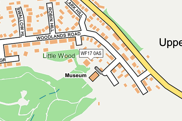
WF17 0AS is located in the Batley West electoral ward, within the metropolitan district of Kirklees and the English Parliamentary constituency of Batley and Spen. The Sub Integrated Care Board (ICB) Location is NHS West Yorkshire ICB - X2C4Y and the police force is West Yorkshire. This postcode has been in use since January 1980.


GetTheData
Source: OS OpenMap – Local (Ordnance Survey)
Source: OS VectorMap District (Ordnance Survey)
Licence: Open Government Licence (requires attribution)
| Easting | 423489 |
| Northing | 425833 |
| Latitude | 53.728386 |
| Longitude | -1.645466 |
GetTheData
Source: Open Postcode Geo
Licence: Open Government Licence
| Country | England |
| Postcode District | WF17 |
➜ See where WF17 is on a map ➜ Where is Batley? | |
GetTheData
Source: Land Registry Price Paid Data
Licence: Open Government Licence
Elevation or altitude of WF17 0AS as distance above sea level:
| Metres | Feet | |
|---|---|---|
| Elevation | 130m | 427ft |
Elevation is measured from the approximate centre of the postcode, to the nearest point on an OS contour line from OS Terrain 50, which has contour spacing of ten vertical metres.
➜ How high above sea level am I? Find the elevation of your current position using your device's GPS.
GetTheData
Source: Open Postcode Elevation
Licence: Open Government Licence
| Ward | Batley West |
| Constituency | Batley And Spen |
GetTheData
Source: ONS Postcode Database
Licence: Open Government Licence
THE LODGE, WILTON PARK, BATLEY, WF17 0AS 2016 3 MAY £155,000 |
GetTheData
Source: HM Land Registry Price Paid Data
Licence: Contains HM Land Registry data © Crown copyright and database right 2025. This data is licensed under the Open Government Licence v3.0.
| Upper Batley Lane Woodlands Rd (Upper Batley Lane) | Upper Batley | 153m |
| Upper Batley Lane Lark Hill (Upper Batley Lane) | Upper Batley | 158m |
| Upper Batley Lane Lark Hill (Upper Batley Lane) | Upper Batley | 173m |
| Upper Batley Lane Woodlands Rd (Upper Batley Lane) | Upper Batley | 181m |
| Windmill La Upper Batley Lane (Windmill Lane) | Howden Clough | 373m |
| Batley Station | 2.5km |
| Dewsbury Station | 4.1km |
| Morley Station | 4.3km |
GetTheData
Source: NaPTAN
Licence: Open Government Licence
GetTheData
Source: ONS Postcode Database
Licence: Open Government Licence


➜ Get more ratings from the Food Standards Agency
GetTheData
Source: Food Standards Agency
Licence: FSA terms & conditions
| Last Collection | |||
|---|---|---|---|
| Location | Mon-Fri | Sat | Distance |
| Woodlands Road / Swallow Hill | 16:00 | 11:00 | 217m |
| Hillside Brookroyd | 17:15 | 11:00 | 480m |
| Anne St | 18:00 | 11:00 | 598m |
GetTheData
Source: Dracos
Licence: Creative Commons Attribution-ShareAlike
The below table lists the International Territorial Level (ITL) codes (formerly Nomenclature of Territorial Units for Statistics (NUTS) codes) and Local Administrative Units (LAU) codes for WF17 0AS:
| ITL 1 Code | Name |
|---|---|
| TLE | Yorkshire and The Humber |
| ITL 2 Code | Name |
| TLE4 | West Yorkshire |
| ITL 3 Code | Name |
| TLE44 | Calderdale and Kirklees |
| LAU 1 Code | Name |
| E08000034 | Kirklees |
GetTheData
Source: ONS Postcode Directory
Licence: Open Government Licence
The below table lists the Census Output Area (OA), Lower Layer Super Output Area (LSOA), and Middle Layer Super Output Area (MSOA) for WF17 0AS:
| Code | Name | |
|---|---|---|
| OA | E00055684 | |
| LSOA | E01011054 | Kirklees 006E |
| MSOA | E02002276 | Kirklees 006 |
GetTheData
Source: ONS Postcode Directory
Licence: Open Government Licence
| WF17 0QS | Woodlands Road | 66m |
| WF17 0QT | Upper Batley Lane | 115m |
| WF17 0QW | Woodlands Road | 132m |
| WF17 0QR | Lark Hill | 178m |
| WF17 0RE | Woodlands Road | 189m |
| WF17 0QU | Upper Batley Lane | 206m |
| WF17 0QP | Robin Hill | 220m |
| WF17 0NP | Upper Batley Lane | 230m |
| WF17 0QN | Swallow Hill | 288m |
| WF17 0NW | Upper Batley Lane | 307m |
GetTheData
Source: Open Postcode Geo; Land Registry Price Paid Data
Licence: Open Government Licence