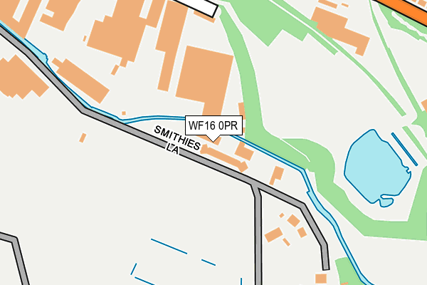
WF16 0PR is located in the Heckmondwike electoral ward, within the metropolitan district of Kirklees and the English Parliamentary constituency of Batley and Spen. The Sub Integrated Care Board (ICB) Location is NHS West Yorkshire ICB - X2C4Y and the police force is West Yorkshire. This postcode has been in use since July 2007.


GetTheData
Source: OS OpenMap – Local (Ordnance Survey)
Source: OS VectorMap District (Ordnance Survey)
Licence: Open Government Licence (requires attribution)
| Easting | 421803 |
| Northing | 422725 |
| Latitude | 53.700525 |
| Longitude | -1.671237 |
GetTheData
Source: Open Postcode Geo
Licence: Open Government Licence
| Country | England |
| Postcode District | WF16 |
➜ See where WF16 is on a map | |
GetTheData
Source: Land Registry Price Paid Data
Licence: Open Government Licence
Elevation or altitude of WF16 0PR as distance above sea level:
| Metres | Feet | |
|---|---|---|
| Elevation | 60m | 197ft |
Elevation is measured from the approximate centre of the postcode, to the nearest point on an OS contour line from OS Terrain 50, which has contour spacing of ten vertical metres.
➜ How high above sea level am I? Find the elevation of your current position using your device's GPS.
GetTheData
Source: Open Postcode Elevation
Licence: Open Government Licence
| Ward | Heckmondwike |
| Constituency | Batley And Spen |
GetTheData
Source: ONS Postcode Database
Licence: Open Government Licence
| Walkley Lane Walkley Ter (Walkley Lane) | Dewsbury Moor | 301m |
| Walkley Lane Walkley Ter (Walkley Lane) | Dewsbury Moor | 332m |
| Walkley Lane Artillery St (Walkley Lane) | Heckmondwike | 340m |
| Walkley Lane Artillery St (Walkley Lane) | Heckmondwike | 344m |
| Station Lane Spen Vale St (Station Lane) | Heckmondwike | 425m |
| Dewsbury Station | 2.7km |
| Ravensthorpe Station | 3km |
| Batley Station | 3.4km |
GetTheData
Source: NaPTAN
Licence: Open Government Licence
| Median download speed | 58.8Mbps |
| Average download speed | 51.7Mbps |
| Maximum download speed | 72.93Mbps |
| Median upload speed | 10.6Mbps |
| Average upload speed | 8.9Mbps |
| Maximum upload speed | 13.15Mbps |
GetTheData
Source: Ofcom
Licence: Ofcom Terms of Use (requires attribution)
GetTheData
Source: ONS Postcode Database
Licence: Open Government Licence


➜ Get more ratings from the Food Standards Agency
GetTheData
Source: Food Standards Agency
Licence: FSA terms & conditions
| Last Collection | |||
|---|---|---|---|
| Location | Mon-Fri | Sat | Distance |
| Moorend Lane | 17:30 | 11:15 | 632m |
| Springhouses | 16:30 | 11:00 | 670m |
| North St / Church St | 17:45 | 11:45 | 733m |
GetTheData
Source: Dracos
Licence: Creative Commons Attribution-ShareAlike
The below table lists the International Territorial Level (ITL) codes (formerly Nomenclature of Territorial Units for Statistics (NUTS) codes) and Local Administrative Units (LAU) codes for WF16 0PR:
| ITL 1 Code | Name |
|---|---|
| TLE | Yorkshire and The Humber |
| ITL 2 Code | Name |
| TLE4 | West Yorkshire |
| ITL 3 Code | Name |
| TLE44 | Calderdale and Kirklees |
| LAU 1 Code | Name |
| E08000034 | Kirklees |
GetTheData
Source: ONS Postcode Directory
Licence: Open Government Licence
The below table lists the Census Output Area (OA), Lower Layer Super Output Area (LSOA), and Middle Layer Super Output Area (MSOA) for WF16 0PR:
| Code | Name | |
|---|---|---|
| OA | E00056256 | |
| LSOA | E01011160 | Kirklees 015D |
| MSOA | E02002285 | Kirklees 015 |
GetTheData
Source: ONS Postcode Directory
Licence: Open Government Licence
| WF16 0PU | Station Lane | 171m |
| WF16 0NH | Spen Vale Street | 183m |
| WF16 0NQ | Spen Vale Street | 215m |
| WF16 0NL | Walkley Lane | 237m |
| WF16 0PN | Mount Villas | 246m |
| WF16 0NU | Walkley Lane | 298m |
| WF16 0NY | Walkley Avenue | 333m |
| WF16 0NJ | Cater Lane | 345m |
| WF16 0NX | Walkley Grove | 347m |
| WF16 0PB | Walkley Villas | 355m |
GetTheData
Source: Open Postcode Geo; Land Registry Price Paid Data
Licence: Open Government Licence