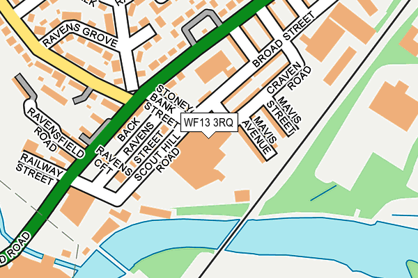
WF13 3RQ is located in the Dewsbury West electoral ward, within the metropolitan district of Kirklees and the English Parliamentary constituency of Dewsbury. The Sub Integrated Care Board (ICB) Location is NHS West Yorkshire ICB - X2C4Y and the police force is West Yorkshire. This postcode has been in use since July 1995.


GetTheData
Source: OS OpenMap – Local (Ordnance Survey)
Source: OS VectorMap District (Ordnance Survey)
Licence: Open Government Licence (requires attribution)
| Easting | 423331 |
| Northing | 420672 |
| Latitude | 53.681992 |
| Longitude | -1.648244 |
GetTheData
Source: Open Postcode Geo
Licence: Open Government Licence
| Country | England |
| Postcode District | WF13 |
➜ See where WF13 is on a map ➜ Where is Dewsbury? | |
GetTheData
Source: Land Registry Price Paid Data
Licence: Open Government Licence
Elevation or altitude of WF13 3RQ as distance above sea level:
| Metres | Feet | |
|---|---|---|
| Elevation | 50m | 164ft |
Elevation is measured from the approximate centre of the postcode, to the nearest point on an OS contour line from OS Terrain 50, which has contour spacing of ten vertical metres.
➜ How high above sea level am I? Find the elevation of your current position using your device's GPS.
GetTheData
Source: Open Postcode Elevation
Licence: Open Government Licence
| Ward | Dewsbury West |
| Constituency | Dewsbury |
GetTheData
Source: ONS Postcode Database
Licence: Open Government Licence
| Huddersfield Road Fire Station (Huddersfield Road) | Scout Hill | 107m |
| Huddersfield Road Fire Station (Huddersfield Road) | Scout Hill | 124m |
| Huddersfield Road Thornville Walk (Huddersfield Road) | Scout Hill | 249m |
| Huddersfield Road Thornville St (Huddersfield Road) | Scout Hill | 274m |
| Huddersfield Rd Park Road (Huddersfield Road) | Ravensthorpe | 403m |
| Ravensthorpe Station | 0.9km |
| Dewsbury Station | 1.5km |
| Mirfield Station | 3.2km |
GetTheData
Source: NaPTAN
Licence: Open Government Licence
GetTheData
Source: ONS Postcode Database
Licence: Open Government Licence


➜ Get more ratings from the Food Standards Agency
GetTheData
Source: Food Standards Agency
Licence: FSA terms & conditions
| Last Collection | |||
|---|---|---|---|
| Location | Mon-Fri | Sat | Distance |
| Scout Hill | 18:00 | 12:30 | 126m |
| Thornhill Road | 18:00 | 12:15 | 428m |
| Aire St/Huddersfield Road | 17:45 | 11:45 | 540m |
GetTheData
Source: Dracos
Licence: Creative Commons Attribution-ShareAlike
The below table lists the International Territorial Level (ITL) codes (formerly Nomenclature of Territorial Units for Statistics (NUTS) codes) and Local Administrative Units (LAU) codes for WF13 3RQ:
| ITL 1 Code | Name |
|---|---|
| TLE | Yorkshire and The Humber |
| ITL 2 Code | Name |
| TLE4 | West Yorkshire |
| ITL 3 Code | Name |
| TLE44 | Calderdale and Kirklees |
| LAU 1 Code | Name |
| E08000034 | Kirklees |
GetTheData
Source: ONS Postcode Directory
Licence: Open Government Licence
The below table lists the Census Output Area (OA), Lower Layer Super Output Area (LSOA), and Middle Layer Super Output Area (MSOA) for WF13 3RQ:
| Code | Name | |
|---|---|---|
| OA | E00056098 | |
| LSOA | E01011141 | Kirklees 019D |
| MSOA | E02002289 | Kirklees 019 |
GetTheData
Source: ONS Postcode Directory
Licence: Open Government Licence
| WF13 3RJ | Stoney Bank Street | 73m |
| WF13 3RU | Mavis Avenue | 79m |
| WF13 3RX | Mavis Street | 94m |
| WF13 3RY | Craven Road | 108m |
| WF13 3RE | Scout Hill Terrace | 109m |
| WF13 3RT | Broad Street | 113m |
| WF13 3RW | Huddersfield Road | 115m |
| WF13 3RS | Thornville Mount | 137m |
| WF13 3EF | Ravens Lodge Terrace | 156m |
| WF13 3EG | Ravens Croft | 166m |
GetTheData
Source: Open Postcode Geo; Land Registry Price Paid Data
Licence: Open Government Licence