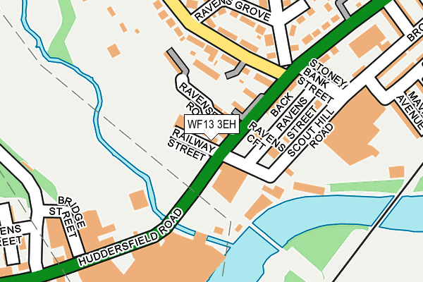
WF13 3EH lies on Huddersfield Road in Dewsbury. WF13 3EH is located in the Dewsbury West electoral ward, within the metropolitan district of Kirklees and the English Parliamentary constituency of Dewsbury. The Sub Integrated Care Board (ICB) Location is NHS West Yorkshire ICB - X2C4Y and the police force is West Yorkshire. This postcode has been in use since January 1980.


GetTheData
Source: OS OpenMap – Local (Ordnance Survey)
Source: OS VectorMap District (Ordnance Survey)
Licence: Open Government Licence (requires attribution)
| Easting | 423116 |
| Northing | 420634 |
| Latitude | 53.681659 |
| Longitude | -1.651502 |
GetTheData
Source: Open Postcode Geo
Licence: Open Government Licence
| Street | Huddersfield Road |
| Town/City | Dewsbury |
| Country | England |
| Postcode District | WF13 |
➜ See where WF13 is on a map ➜ Where is Dewsbury? | |
GetTheData
Source: Land Registry Price Paid Data
Licence: Open Government Licence
Elevation or altitude of WF13 3EH as distance above sea level:
| Metres | Feet | |
|---|---|---|
| Elevation | 50m | 164ft |
Elevation is measured from the approximate centre of the postcode, to the nearest point on an OS contour line from OS Terrain 50, which has contour spacing of ten vertical metres.
➜ How high above sea level am I? Find the elevation of your current position using your device's GPS.
GetTheData
Source: Open Postcode Elevation
Licence: Open Government Licence
| Ward | Dewsbury West |
| Constituency | Dewsbury |
GetTheData
Source: ONS Postcode Database
Licence: Open Government Licence
RAVENS WHARF HOTEL, HUDDERSFIELD ROAD, DEWSBURY, WF13 3EH 2002 15 JUL £142,500 |
GetTheData
Source: HM Land Registry Price Paid Data
Licence: Contains HM Land Registry data © Crown copyright and database right 2025. This data is licensed under the Open Government Licence v3.0.
| Huddersfield Road Fire Station (Huddersfield Road) | Scout Hill | 196m |
| Huddersfield Road Fire Station (Huddersfield Road) | Scout Hill | 208m |
| Huddersfield Rd Park Road (Huddersfield Road) | Ravensthorpe | 210m |
| Huddersfield Road Bridge St (Huddersfield Road) | Ravensthorpe | 258m |
| Ravenshouse Road Dewsbury Cemetery (Ravenshouse Road) | Dewsbury Moor | 347m |
| Ravensthorpe Station | 0.7km |
| Dewsbury Station | 1.7km |
| Mirfield Station | 2.9km |
GetTheData
Source: NaPTAN
Licence: Open Government Licence
GetTheData
Source: ONS Postcode Database
Licence: Open Government Licence


➜ Get more ratings from the Food Standards Agency
GetTheData
Source: Food Standards Agency
Licence: FSA terms & conditions
| Last Collection | |||
|---|---|---|---|
| Location | Mon-Fri | Sat | Distance |
| Scout Hill | 18:00 | 12:30 | 158m |
| Aire St/Huddersfield Road | 17:45 | 11:45 | 336m |
| 122 Spen Valley Road | 17:45 | 12:30 | 636m |
GetTheData
Source: Dracos
Licence: Creative Commons Attribution-ShareAlike
The below table lists the International Territorial Level (ITL) codes (formerly Nomenclature of Territorial Units for Statistics (NUTS) codes) and Local Administrative Units (LAU) codes for WF13 3EH:
| ITL 1 Code | Name |
|---|---|
| TLE | Yorkshire and The Humber |
| ITL 2 Code | Name |
| TLE4 | West Yorkshire |
| ITL 3 Code | Name |
| TLE44 | Calderdale and Kirklees |
| LAU 1 Code | Name |
| E08000034 | Kirklees |
GetTheData
Source: ONS Postcode Directory
Licence: Open Government Licence
The below table lists the Census Output Area (OA), Lower Layer Super Output Area (LSOA), and Middle Layer Super Output Area (MSOA) for WF13 3EH:
| Code | Name | |
|---|---|---|
| OA | E00056132 | |
| LSOA | E01011139 | Kirklees 019B |
| MSOA | E02002289 | Kirklees 019 |
GetTheData
Source: ONS Postcode Directory
Licence: Open Government Licence
| WF13 3EQ | Ravensfield Road | 52m |
| WF13 3EG | Ravens Croft | 87m |
| WF13 3RE | Scout Hill Terrace | 110m |
| WF13 3QP | Ravenshouse Road | 115m |
| WF13 3RW | Huddersfield Road | 119m |
| WF13 3RJ | Stoney Bank Street | 171m |
| WF13 3JF | Huddersfield Road | 182m |
| WF13 3QH | Ravens Grove | 182m |
| WF13 3QW | Ravenshouse Road | 207m |
| WF13 3QQ | Ravens Crescent | 226m |
GetTheData
Source: Open Postcode Geo; Land Registry Price Paid Data
Licence: Open Government Licence