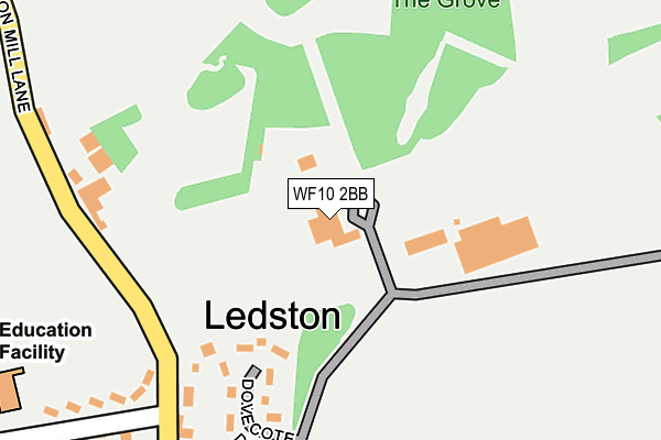
WF10 2BB is located in the Kippax & Methley electoral ward, within the metropolitan district of Leeds and the English Parliamentary constituency of Elmet and Rothwell. The Sub Integrated Care Board (ICB) Location is NHS West Yorkshire ICB - 15F and the police force is West Yorkshire. This postcode has been in use since January 1980.


GetTheData
Source: OS OpenMap – Local (Ordnance Survey)
Source: OS VectorMap District (Ordnance Survey)
Licence: Open Government Licence (requires attribution)
| Easting | 443628 |
| Northing | 428918 |
| Latitude | 53.754824 |
| Longitude | -1.339808 |
GetTheData
Source: Open Postcode Geo
Licence: Open Government Licence
| Country | England |
| Postcode District | WF10 |
➜ See where WF10 is on a map ➜ Where is Ledston? | |
GetTheData
Source: Land Registry Price Paid Data
Licence: Open Government Licence
Elevation or altitude of WF10 2BB as distance above sea level:
| Metres | Feet | |
|---|---|---|
| Elevation | 50m | 164ft |
Elevation is measured from the approximate centre of the postcode, to the nearest point on an OS contour line from OS Terrain 50, which has contour spacing of ten vertical metres.
➜ How high above sea level am I? Find the elevation of your current position using your device's GPS.
GetTheData
Source: Open Postcode Elevation
Licence: Open Government Licence
| Ward | Kippax & Methley |
| Constituency | Elmet And Rothwell |
GetTheData
Source: ONS Postcode Database
Licence: Open Government Licence
| Main Street Green Ln (Main Street) | Ledston | 291m |
| Main Street Green Ln (Main Street) | Ledston | 296m |
| White Horse (Main Street) | Ledston | 420m |
| Lady E Hastings Cof E School (Green Lane) | Ledston | 424m |
| White Horse (Main Street) | Ledston | 426m |
| Castleford Station | 3.6km |
| Micklefield Station | 3.9km |
| East Garforth Station | 4.6km |
GetTheData
Source: NaPTAN
Licence: Open Government Licence
GetTheData
Source: ONS Postcode Database
Licence: Open Government Licence


➜ Get more ratings from the Food Standards Agency
GetTheData
Source: Food Standards Agency
Licence: FSA terms & conditions
| Last Collection | |||
|---|---|---|---|
| Location | Mon-Fri | Sat | Distance |
| Ledston | 16:15 | 11:00 | 405m |
| Barnsdale Road / Park Lane | 16:15 | 11:15 | 1,444m |
| In Wall Of 22 Main Street | 16:15 | 11:15 | 2,166m |
GetTheData
Source: Dracos
Licence: Creative Commons Attribution-ShareAlike
The below table lists the International Territorial Level (ITL) codes (formerly Nomenclature of Territorial Units for Statistics (NUTS) codes) and Local Administrative Units (LAU) codes for WF10 2BB:
| ITL 1 Code | Name |
|---|---|
| TLE | Yorkshire and The Humber |
| ITL 2 Code | Name |
| TLE4 | West Yorkshire |
| ITL 3 Code | Name |
| TLE42 | Leeds |
| LAU 1 Code | Name |
| E08000035 | Leeds |
GetTheData
Source: ONS Postcode Directory
Licence: Open Government Licence
The below table lists the Census Output Area (OA), Lower Layer Super Output Area (LSOA), and Middle Layer Super Output Area (MSOA) for WF10 2BB:
| Code | Name | |
|---|---|---|
| OA | E00056960 | |
| LSOA | E01011299 | Leeds 088B |
| MSOA | E02002417 | Leeds 088 |
GetTheData
Source: ONS Postcode Directory
Licence: Open Government Licence
| WF10 2BA | Dovecote Drive | 204m |
| WF10 2AB | Main Street | 319m |
| WF10 2BD | Green Lane | 352m |
| WF10 2AU | Hall Lane | 362m |
| WF10 2BL | White Horse Fold | 432m |
| WF10 2AA | Main Street | 608m |
| WF10 2AX | Barnsdale Road | 1035m |
| WF10 2AP | Park Lane | 1429m |
| WF10 2BH | Newton Lane | 1450m |
| WF10 2AW | Barnsdale Road | 1474m |
GetTheData
Source: Open Postcode Geo; Land Registry Price Paid Data
Licence: Open Government Licence