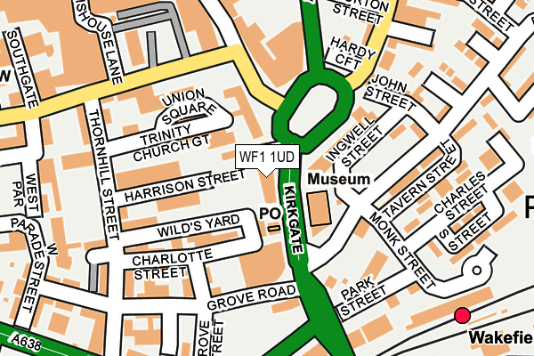
WF1 1UD lies on Kirkgate in Wakefield. WF1 1UD is located in the Wakefield North electoral ward, within the metropolitan district of Wakefield and the English Parliamentary constituency of Wakefield. The Sub Integrated Care Board (ICB) Location is NHS West Yorkshire ICB - 03R and the police force is West Yorkshire. This postcode has been in use since January 1980.


GetTheData
Source: OS OpenMap – Local (Ordnance Survey)
Source: OS VectorMap District (Ordnance Survey)
Licence: Open Government Licence (requires attribution)
| Easting | 433621 |
| Northing | 420507 |
| Latitude | 53.679950 |
| Longitude | -1.492476 |
GetTheData
Source: Open Postcode Geo
Licence: Open Government Licence
| Street | Kirkgate |
| Town/City | Wakefield |
| Country | England |
| Postcode District | WF1 |
➜ See where WF1 is on a map ➜ Where is Wakefield? | |
GetTheData
Source: Land Registry Price Paid Data
Licence: Open Government Licence
Elevation or altitude of WF1 1UD as distance above sea level:
| Metres | Feet | |
|---|---|---|
| Elevation | 30m | 98ft |
Elevation is measured from the approximate centre of the postcode, to the nearest point on an OS contour line from OS Terrain 50, which has contour spacing of ten vertical metres.
➜ How high above sea level am I? Find the elevation of your current position using your device's GPS.
GetTheData
Source: Open Postcode Elevation
Licence: Open Government Licence
| Ward | Wakefield North |
| Constituency | Wakefield |
GetTheData
Source: ONS Postcode Database
Licence: Open Government Licence
| Kirkgate | Wakefield City Centre | 106m |
| Kirkgate | Wakefield City Centre | 164m |
| George Street | Wakefield City Centre | 255m |
| Kirkgate Rail Station K7 (Kirkgate Rail Station) | Wakefield | 257m |
| Kirkgate | Wakefield City Centre | 269m |
| Wakefield Kirkgate Station | 0.3km |
| Wakefield Westgate Station | 1km |
| Sandal & Agbrigg Station | 2km |
GetTheData
Source: NaPTAN
Licence: Open Government Licence
GetTheData
Source: ONS Postcode Database
Licence: Open Government Licence


➜ Get more ratings from the Food Standards Agency
GetTheData
Source: Food Standards Agency
Licence: FSA terms & conditions
| Last Collection | |||
|---|---|---|---|
| Location | Mon-Fri | Sat | Distance |
| Kirgate P.o. | 18:30 | 12:00 | 54m |
| John Street | 17:30 | 11:15 | 175m |
| Kirkgate | 18:30 | 12:00 | 248m |
GetTheData
Source: Dracos
Licence: Creative Commons Attribution-ShareAlike
The below table lists the International Territorial Level (ITL) codes (formerly Nomenclature of Territorial Units for Statistics (NUTS) codes) and Local Administrative Units (LAU) codes for WF1 1UD:
| ITL 1 Code | Name |
|---|---|
| TLE | Yorkshire and The Humber |
| ITL 2 Code | Name |
| TLE4 | West Yorkshire |
| ITL 3 Code | Name |
| TLE45 | Wakefield |
| LAU 1 Code | Name |
| E08000036 | Wakefield |
GetTheData
Source: ONS Postcode Directory
Licence: Open Government Licence
The below table lists the Census Output Area (OA), Lower Layer Super Output Area (LSOA), and Middle Layer Super Output Area (MSOA) for WF1 1UD:
| Code | Name | |
|---|---|---|
| OA | E00060067 | |
| LSOA | E01011916 | Wakefield 017D |
| MSOA | E02002454 | Wakefield 017 |
GetTheData
Source: ONS Postcode Directory
Licence: Open Government Licence
| WF1 1UE | Kirkgate | 56m |
| WF1 1TU | Kirkgate | 79m |
| WF1 1TS | Kirkgate | 103m |
| WF1 1UH | Charlotte Street | 112m |
| WF1 1UW | Grove Road | 137m |
| WF1 4EP | Tavern Street | 138m |
| WF1 1JG | Kirkgate | 140m |
| WF1 1NL | Thornhill Street | 159m |
| WF1 4DN | Hardy Croft | 168m |
| WF1 4PN | John Street | 174m |
GetTheData
Source: Open Postcode Geo; Land Registry Price Paid Data
Licence: Open Government Licence