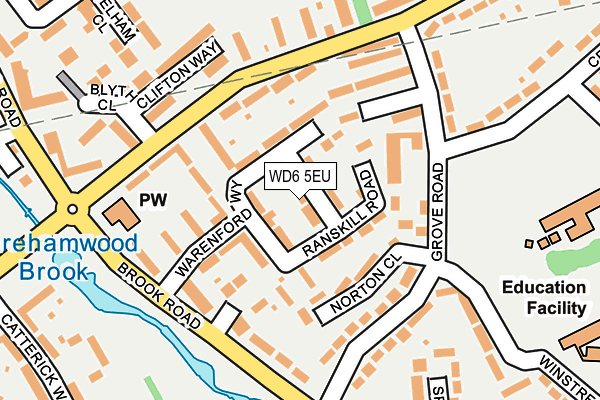
WD6 5EU lies on Ranskill Road in Borehamwood. WD6 5EU is located in the Borehamwood Cowley Hill electoral ward, within the local authority district of Hertsmere and the English Parliamentary constituency of Hertsmere. The Sub Integrated Care Board (ICB) Location is NHS Hertfordshire and West Essex ICB - 06N and the police force is Hertfordshire. This postcode has been in use since January 1980.


GetTheData
Source: OS OpenMap – Local (Ordnance Survey)
Source: OS VectorMap District (Ordnance Survey)
Licence: Open Government Licence (requires attribution)
| Easting | 519196 |
| Northing | 197754 |
| Latitude | 51.665931 |
| Longitude | -0.277917 |
GetTheData
Source: Open Postcode Geo
Licence: Open Government Licence
| Street | Ranskill Road |
| Town/City | Borehamwood |
| Country | England |
| Postcode District | WD6 |
➜ See where WD6 is on a map ➜ Where is Borehamwood? | |
GetTheData
Source: Land Registry Price Paid Data
Licence: Open Government Licence
Elevation or altitude of WD6 5EU as distance above sea level:
| Metres | Feet | |
|---|---|---|
| Elevation | 90m | 295ft |
Elevation is measured from the approximate centre of the postcode, to the nearest point on an OS contour line from OS Terrain 50, which has contour spacing of ten vertical metres.
➜ How high above sea level am I? Find the elevation of your current position using your device's GPS.
GetTheData
Source: Open Postcode Elevation
Licence: Open Government Licence
| Ward | Borehamwood Cowley Hill |
| Constituency | Hertsmere |
GetTheData
Source: ONS Postcode Database
Licence: Open Government Licence
| Blyth Close (Gateshead Road) | Borehamwood | 136m |
| Crown Road (Grove Road) | Borehamwood | 138m |
| Crown Road (Grove Road) | Borehamwood | 145m |
| Blyth Close (Gateshead Road) | Borehamwood | 147m |
| Brook Road (Grove Road) | Borehamwood | 191m |
| Elstree & Borehamwood Station | 1.4km |
| Radlett Station | 3.5km |
GetTheData
Source: NaPTAN
Licence: Open Government Licence
| Percentage of properties with Next Generation Access | 100.0% |
| Percentage of properties with Superfast Broadband | 100.0% |
| Percentage of properties with Ultrafast Broadband | 100.0% |
| Percentage of properties with Full Fibre Broadband | 0.0% |
Superfast Broadband is between 30Mbps and 300Mbps
Ultrafast Broadband is > 300Mbps
| Median download speed | 100.0Mbps |
| Average download speed | 107.5Mbps |
| Maximum download speed | 350.00Mbps |
| Median upload speed | 6.9Mbps |
| Average upload speed | 5.5Mbps |
| Maximum upload speed | 10.00Mbps |
| Percentage of properties unable to receive 2Mbps | 0.0% |
| Percentage of properties unable to receive 5Mbps | 0.0% |
| Percentage of properties unable to receive 10Mbps | 0.0% |
| Percentage of properties unable to receive 30Mbps | 0.0% |
GetTheData
Source: Ofcom
Licence: Ofcom Terms of Use (requires attribution)
Estimated total energy consumption in WD6 5EU by fuel type, 2015.
| Consumption (kWh) | 179,543 |
|---|---|
| Meter count | 15 |
| Mean (kWh/meter) | 11,970 |
| Median (kWh/meter) | 10,665 |
| Consumption (kWh) | 74,690 |
|---|---|
| Meter count | 17 |
| Mean (kWh/meter) | 4,394 |
| Median (kWh/meter) | 3,625 |
GetTheData
Source: Postcode level gas estimates: 2015 (experimental)
Source: Postcode level electricity estimates: 2015 (experimental)
Licence: Open Government Licence
GetTheData
Source: ONS Postcode Database
Licence: Open Government Licence


➜ Get more ratings from the Food Standards Agency
GetTheData
Source: Food Standards Agency
Licence: FSA terms & conditions
| Last Collection | |||
|---|---|---|---|
| Location | Mon-Fri | Sat | Distance |
| Stevenage Crescent | 17:30 | 11:30 | 773m |
| Farriers Way | 17:30 | 11:30 | 913m |
| Balcon Way | 17:30 | 11:30 | 992m |
GetTheData
Source: Dracos
Licence: Creative Commons Attribution-ShareAlike
The below table lists the International Territorial Level (ITL) codes (formerly Nomenclature of Territorial Units for Statistics (NUTS) codes) and Local Administrative Units (LAU) codes for WD6 5EU:
| ITL 1 Code | Name |
|---|---|
| TLH | East |
| ITL 2 Code | Name |
| TLH2 | Bedfordshire and Hertfordshire |
| ITL 3 Code | Name |
| TLH23 | Hertfordshire CC |
| LAU 1 Code | Name |
| E07000098 | Hertsmere |
GetTheData
Source: ONS Postcode Directory
Licence: Open Government Licence
The below table lists the Census Output Area (OA), Lower Layer Super Output Area (LSOA), and Middle Layer Super Output Area (MSOA) for WD6 5EU:
| Code | Name | |
|---|---|---|
| OA | E00119533 | |
| LSOA | E01023538 | Hertsmere 006E |
| MSOA | E02004901 | Hertsmere 006 |
GetTheData
Source: ONS Postcode Directory
Licence: Open Government Licence
| WD6 5ET | Ranskill Road | 30m |
| WD6 5EN | Warenford Way | 42m |
| WD6 5EX | Ranskill Road | 60m |
| WD6 5ES | Warenford Way | 65m |
| WD6 5EY | Ranskill Road | 68m |
| WD6 5ER | Warenford Way | 71m |
| WD6 5DW | Norton Close | 95m |
| WD6 5EP | Stannington Path | 97m |
| WD6 5EW | Warenford Way | 103m |
| WD6 5EZ | Fairburn Close | 106m |
GetTheData
Source: Open Postcode Geo; Land Registry Price Paid Data
Licence: Open Government Licence