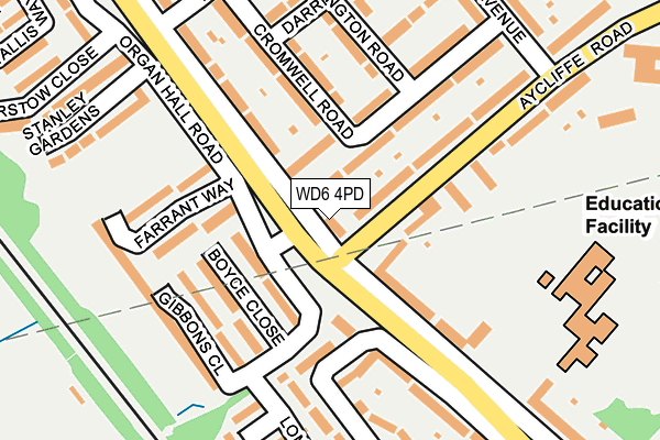
WD6 4PD lies on Theobald Street in Borehamwood. WD6 4PD is located in the Borehamwood Brookmeadow electoral ward, within the local authority district of Hertsmere and the English Parliamentary constituency of Hertsmere. The Sub Integrated Care Board (ICB) Location is NHS Hertfordshire and West Essex ICB - 06N and the police force is Hertfordshire. This postcode has been in use since January 1980.


GetTheData
Source: OS OpenMap – Local (Ordnance Survey)
Source: OS VectorMap District (Ordnance Survey)
Licence: Open Government Licence (requires attribution)
| Easting | 518338 |
| Northing | 197723 |
| Latitude | 51.665833 |
| Longitude | -0.290328 |
GetTheData
Source: Open Postcode Geo
Licence: Open Government Licence
| Street | Theobald Street |
| Town/City | Borehamwood |
| Country | England |
| Postcode District | WD6 |
➜ See where WD6 is on a map ➜ Where is Borehamwood? | |
GetTheData
Source: Land Registry Price Paid Data
Licence: Open Government Licence
Elevation or altitude of WD6 4PD as distance above sea level:
| Metres | Feet | |
|---|---|---|
| Elevation | 80m | 262ft |
Elevation is measured from the approximate centre of the postcode, to the nearest point on an OS contour line from OS Terrain 50, which has contour spacing of ten vertical metres.
➜ How high above sea level am I? Find the elevation of your current position using your device's GPS.
GetTheData
Source: Open Postcode Elevation
Licence: Open Government Licence
| Ward | Borehamwood Brookmeadow |
| Constituency | Hertsmere |
GetTheData
Source: ONS Postcode Database
Licence: Open Government Licence
| Theobald Street (Aycliffe Road) | Borehamwood | 35m |
| Theobald Street (Aycliffe Road) | Borehamwood | 57m |
| Farrant Way (Organ Hall Road) | Borehamwood | 77m |
| Stevenage Crescent (Theobald Street) | Borehamwood | 87m |
| Stevenage Crescent (Theobald Street) | Borehamwood | 131m |
| Elstree & Borehamwood Station | 1.6km |
| Radlett Station | 2.8km |
| Bricket Wood Station | 6.5km |
GetTheData
Source: NaPTAN
Licence: Open Government Licence
| Percentage of properties with Next Generation Access | 100.0% |
| Percentage of properties with Superfast Broadband | 100.0% |
| Percentage of properties with Ultrafast Broadband | 100.0% |
| Percentage of properties with Full Fibre Broadband | 0.0% |
Superfast Broadband is between 30Mbps and 300Mbps
Ultrafast Broadband is > 300Mbps
| Percentage of properties unable to receive 2Mbps | 0.0% |
| Percentage of properties unable to receive 5Mbps | 0.0% |
| Percentage of properties unable to receive 10Mbps | 0.0% |
| Percentage of properties unable to receive 30Mbps | 0.0% |
GetTheData
Source: Ofcom
Licence: Ofcom Terms of Use (requires attribution)
GetTheData
Source: ONS Postcode Database
Licence: Open Government Licence


➜ Get more ratings from the Food Standards Agency
GetTheData
Source: Food Standards Agency
Licence: FSA terms & conditions
| Last Collection | |||
|---|---|---|---|
| Location | Mon-Fri | Sat | Distance |
| Stevenage Crescent | 17:30 | 11:30 | 201m |
| Borehamwood P.o | 18:00 | 12:00 | 931m |
| Farriers Way | 17:30 | 11:30 | 1,414m |
GetTheData
Source: Dracos
Licence: Creative Commons Attribution-ShareAlike
The below table lists the International Territorial Level (ITL) codes (formerly Nomenclature of Territorial Units for Statistics (NUTS) codes) and Local Administrative Units (LAU) codes for WD6 4PD:
| ITL 1 Code | Name |
|---|---|
| TLH | East |
| ITL 2 Code | Name |
| TLH2 | Bedfordshire and Hertfordshire |
| ITL 3 Code | Name |
| TLH23 | Hertfordshire CC |
| LAU 1 Code | Name |
| E07000098 | Hertsmere |
GetTheData
Source: ONS Postcode Directory
Licence: Open Government Licence
The below table lists the Census Output Area (OA), Lower Layer Super Output Area (LSOA), and Middle Layer Super Output Area (MSOA) for WD6 4PD:
| Code | Name | |
|---|---|---|
| OA | E00119514 | |
| LSOA | E01023533 | Hertsmere 007E |
| MSOA | E02004902 | Hertsmere 007 |
GetTheData
Source: ONS Postcode Directory
Licence: Open Government Licence
| WD6 4LN | Cromwell Road | 64m |
| WD6 4TH | Organ Hall Road | 83m |
| WD6 4NP | Theobald Street | 98m |
| WD6 4JP | Aycliffe Road | 116m |
| WD6 4TD | Boyce Close | 118m |
| WD6 4PB | Theobald Street | 124m |
| WD6 4LJ | Cromwell Road | 137m |
| WD6 4PE | Theobald Street | 138m |
| WD6 4TE | Farrant Way | 141m |
| WD6 4JW | Aycliffe Road | 142m |
GetTheData
Source: Open Postcode Geo; Land Registry Price Paid Data
Licence: Open Government Licence