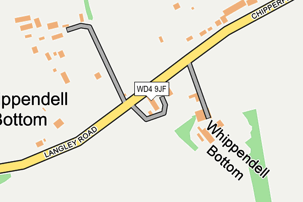
WD4 9JF lies on The Grove in Chipperfield, Kings Langley. WD4 9JF is located in the Bovingdon, Flaunden and Chipperfield electoral ward, within the local authority district of Dacorum and the English Parliamentary constituency of South West Hertfordshire. The Sub Integrated Care Board (ICB) Location is NHS Hertfordshire and West Essex ICB - 06N and the police force is Hertfordshire. This postcode has been in use since January 1980.


GetTheData
Source: OS OpenMap – Local (Ordnance Survey)
Source: OS VectorMap District (Ordnance Survey)
Licence: Open Government Licence (requires attribution)
| Easting | 505407 |
| Northing | 202354 |
| Latitude | 51.710028 |
| Longitude | -0.475826 |
GetTheData
Source: Open Postcode Geo
Licence: Open Government Licence
| Street | The Grove |
| Locality | Chipperfield |
| Town/City | Kings Langley |
| Country | England |
| Postcode District | WD4 |
➜ See where WD4 is on a map ➜ Where is Whippendell Bottom? | |
GetTheData
Source: Land Registry Price Paid Data
Licence: Open Government Licence
Elevation or altitude of WD4 9JF as distance above sea level:
| Metres | Feet | |
|---|---|---|
| Elevation | 110m | 361ft |
Elevation is measured from the approximate centre of the postcode, to the nearest point on an OS contour line from OS Terrain 50, which has contour spacing of ten vertical metres.
➜ How high above sea level am I? Find the elevation of your current position using your device's GPS.
GetTheData
Source: Open Postcode Elevation
Licence: Open Government Licence
| Ward | Bovingdon, Flaunden And Chipperfield |
| Constituency | South West Hertfordshire |
GetTheData
Source: ONS Postcode Database
Licence: Open Government Licence
| Whippendell Farm (Langley Road) | Whippendell Bottom | 50m |
| Whippendell Farm (Langley Road) | Whippendell Bottom | 58m |
| Kings Langley Riding School (Chipperfield Road) | Whippendell Bottom | 199m |
| Kings Langley Riding School (Chipperfield Road) | Whippendell Bottom | 220m |
| Megg Lane (Langley Road) | Chipperfield | 515m |
| Kings Langley Station | 2.6km |
| Apsley Station | 2.7km |
| Hemel Hempstead Station | 3.7km |
GetTheData
Source: NaPTAN
Licence: Open Government Licence
| Percentage of properties with Next Generation Access | 100.0% |
| Percentage of properties with Superfast Broadband | 0.0% |
| Percentage of properties with Ultrafast Broadband | 0.0% |
| Percentage of properties with Full Fibre Broadband | 0.0% |
Superfast Broadband is between 30Mbps and 300Mbps
Ultrafast Broadband is > 300Mbps
| Median download speed | 13.1Mbps |
| Average download speed | 11.4Mbps |
| Maximum download speed | 16.52Mbps |
| Median upload speed | 1.2Mbps |
| Average upload speed | 1.1Mbps |
| Maximum upload speed | 1.22Mbps |
| Percentage of properties unable to receive 2Mbps | 0.0% |
| Percentage of properties unable to receive 5Mbps | 0.0% |
| Percentage of properties unable to receive 10Mbps | 0.0% |
| Percentage of properties unable to receive 30Mbps | 100.0% |
GetTheData
Source: Ofcom
Licence: Ofcom Terms of Use (requires attribution)
Estimated total energy consumption in WD4 9JF by fuel type, 2015.
| Consumption (kWh) | 165,031 |
|---|---|
| Meter count | 7 |
| Mean (kWh/meter) | 23,576 |
| Median (kWh/meter) | 21,727 |
| Consumption (kWh) | 36,093 |
|---|---|
| Meter count | 6 |
| Mean (kWh/meter) | 6,015 |
| Median (kWh/meter) | 4,870 |
GetTheData
Source: Postcode level gas estimates: 2015 (experimental)
Source: Postcode level electricity estimates: 2015 (experimental)
Licence: Open Government Licence
GetTheData
Source: ONS Postcode Database
Licence: Open Government Licence


➜ Get more ratings from the Food Standards Agency
GetTheData
Source: Food Standards Agency
Licence: FSA terms & conditions
| Last Collection | |||
|---|---|---|---|
| Location | Mon-Fri | Sat | Distance |
| Chipperfield Road | 17:00 | 08:00 | 291m |
| Kings Langley Sorting Office | 17:30 | 11:30 | 1,795m |
| Railway Terrace | 17:30 | 08:00 | 1,889m |
GetTheData
Source: Dracos
Licence: Creative Commons Attribution-ShareAlike
The below table lists the International Territorial Level (ITL) codes (formerly Nomenclature of Territorial Units for Statistics (NUTS) codes) and Local Administrative Units (LAU) codes for WD4 9JF:
| ITL 1 Code | Name |
|---|---|
| TLH | East |
| ITL 2 Code | Name |
| TLH2 | Bedfordshire and Hertfordshire |
| ITL 3 Code | Name |
| TLH23 | Hertfordshire CC |
| LAU 1 Code | Name |
| E07000096 | Dacorum |
GetTheData
Source: ONS Postcode Directory
Licence: Open Government Licence
The below table lists the Census Output Area (OA), Lower Layer Super Output Area (LSOA), and Middle Layer Super Output Area (MSOA) for WD4 9JF:
| Code | Name | |
|---|---|---|
| OA | E00118762 | |
| LSOA | E01023375 | Dacorum 021C |
| MSOA | E02004876 | Dacorum 021 |
GetTheData
Source: ONS Postcode Directory
Licence: Open Government Licence
| WD4 9JG | Langley Road | 208m |
| WD4 9JQ | Langley Road | 376m |
| WD4 9JD | Chipperfield Road | 411m |
| WD4 9JW | Megg Lane | 439m |
| WD4 9JN | Megg Lane | 552m |
| WD4 9JL | Wayside | 600m |
| WD4 9JP | Langley Road | 619m |
| WD4 9JJ | Wayside | 679m |
| WD4 9EZ | Scatterdells Lane | 843m |
| WD4 9JR | Langley Road | 862m |
GetTheData
Source: Open Postcode Geo; Land Registry Price Paid Data
Licence: Open Government Licence