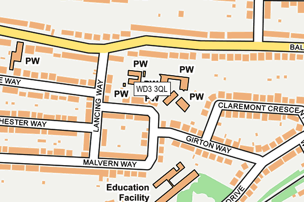
WD3 3QL lies on Malvern Way in Croxley Green, Rickmansworth. WD3 3QL is located in the Durrants electoral ward, within the local authority district of Three Rivers and the English Parliamentary constituency of South West Hertfordshire. The Sub Integrated Care Board (ICB) Location is NHS Hertfordshire and West Essex ICB - 06N and the police force is Hertfordshire. This postcode has been in use since January 1980.


GetTheData
Source: OS OpenMap – Local (Ordnance Survey)
Source: OS VectorMap District (Ordnance Survey)
Licence: Open Government Licence (requires attribution)
| Easting | 507995 |
| Northing | 195955 |
| Latitude | 51.652024 |
| Longitude | -0.440362 |
GetTheData
Source: Open Postcode Geo
Licence: Open Government Licence
| Street | Malvern Way |
| Locality | Croxley Green |
| Town/City | Rickmansworth |
| Country | England |
| Postcode District | WD3 |
➜ See where WD3 is on a map ➜ Where is Rickmansworth? | |
GetTheData
Source: Land Registry Price Paid Data
Licence: Open Government Licence
Elevation or altitude of WD3 3QL as distance above sea level:
| Metres | Feet | |
|---|---|---|
| Elevation | 70m | 230ft |
Elevation is measured from the approximate centre of the postcode, to the nearest point on an OS contour line from OS Terrain 50, which has contour spacing of ten vertical metres.
➜ How high above sea level am I? Find the elevation of your current position using your device's GPS.
GetTheData
Source: Open Postcode Elevation
Licence: Open Government Licence
| Ward | Durrants |
| Constituency | South West Hertfordshire |
GetTheData
Source: ONS Postcode Database
Licence: Open Government Licence
| Lancing Way (Baldwins Lane) | Croxley Green | 182m |
| Lancing Way (Baldwins Lane) | Croxley Green | 270m |
| Durrants Drive (Baldwins Lane) | Croxley Green | 278m |
| Durrants Drive (Baldwins Lane) | Croxley Green | 303m |
| Hastings Way (Durrants Drive) | Croxley Green | 318m |
| Croxley Underground Station | Croxley Green | 562m |
| Rickmansworth Station | 2.6km |
| Watford Junction Station | 3.3km |
| Watford High Street Station | 3.4km |
GetTheData
Source: NaPTAN
Licence: Open Government Licence
| Percentage of properties with Next Generation Access | 100.0% |
| Percentage of properties with Superfast Broadband | 100.0% |
| Percentage of properties with Ultrafast Broadband | 100.0% |
| Percentage of properties with Full Fibre Broadband | 0.0% |
Superfast Broadband is between 30Mbps and 300Mbps
Ultrafast Broadband is > 300Mbps
| Median download speed | 100.0Mbps |
| Average download speed | 150.6Mbps |
| Maximum download speed | 350.00Mbps |
| Median upload speed | 5.4Mbps |
| Average upload speed | 5.4Mbps |
| Maximum upload speed | 10.00Mbps |
| Percentage of properties unable to receive 2Mbps | 0.0% |
| Percentage of properties unable to receive 5Mbps | 0.0% |
| Percentage of properties unable to receive 10Mbps | 0.0% |
| Percentage of properties unable to receive 30Mbps | 0.0% |
GetTheData
Source: Ofcom
Licence: Ofcom Terms of Use (requires attribution)
Estimated total energy consumption in WD3 3QL by fuel type, 2015.
| Consumption (kWh) | 268,246 |
|---|---|
| Meter count | 12 |
| Mean (kWh/meter) | 22,354 |
| Median (kWh/meter) | 19,651 |
| Consumption (kWh) | 36,796 |
|---|---|
| Meter count | 9 |
| Mean (kWh/meter) | 4,088 |
| Median (kWh/meter) | 3,442 |
GetTheData
Source: Postcode level gas estimates: 2015 (experimental)
Source: Postcode level electricity estimates: 2015 (experimental)
Licence: Open Government Licence
GetTheData
Source: ONS Postcode Database
Licence: Open Government Licence


➜ Get more ratings from the Food Standards Agency
GetTheData
Source: Food Standards Agency
Licence: FSA terms & conditions
| Last Collection | |||
|---|---|---|---|
| Location | Mon-Fri | Sat | Distance |
| Barton Way Croxley Green | 17:00 | 12:00 | 495m |
| Links Way Croxley Green | 17:30 | 11:30 | 560m |
| Watford Road Croxley Green | 17:30 | 12:00 | 601m |
GetTheData
Source: Dracos
Licence: Creative Commons Attribution-ShareAlike
The below table lists the International Territorial Level (ITL) codes (formerly Nomenclature of Territorial Units for Statistics (NUTS) codes) and Local Administrative Units (LAU) codes for WD3 3QL:
| ITL 1 Code | Name |
|---|---|
| TLH | East |
| ITL 2 Code | Name |
| TLH2 | Bedfordshire and Hertfordshire |
| ITL 3 Code | Name |
| TLH23 | Hertfordshire CC |
| LAU 1 Code | Name |
| E07000102 | Three Rivers |
GetTheData
Source: ONS Postcode Directory
Licence: Open Government Licence
The below table lists the Census Output Area (OA), Lower Layer Super Output Area (LSOA), and Middle Layer Super Output Area (MSOA) for WD3 3QL:
| Code | Name | |
|---|---|---|
| OA | E00120952 | |
| LSOA | E01023821 | Three Rivers 006C |
| MSOA | E02004961 | Three Rivers 006 |
GetTheData
Source: ONS Postcode Directory
Licence: Open Government Licence
| WD3 3QJ | Malvern Way | 66m |
| WD3 3LW | Lancing Way | 89m |
| WD3 3LL | Baldwins Lane | 113m |
| WD3 3QG | Malvern Way | 119m |
| WD3 3LJ | Baldwins Lane | 141m |
| WD3 3LN | Lancing Way | 144m |
| WD3 3QW | Girton Way | 145m |
| WD3 3QQ | Malvern Way | 147m |
| WD3 3QN | Girton Way | 153m |
| WD3 3QR | Claremont Crescent | 207m |
GetTheData
Source: Open Postcode Geo; Land Registry Price Paid Data
Licence: Open Government Licence