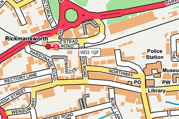
WD3 1QF lies on Northway in Rickmansworth. WD3 1QF is located in the Rickmansworth Town electoral ward, within the local authority district of Three Rivers and the English Parliamentary constituency of South West Hertfordshire. The Sub Integrated Care Board (ICB) Location is NHS Hertfordshire and West Essex ICB - 06N and the police force is Hertfordshire. This postcode has been in use since December 2001.


GetTheData
Source: OS OpenMap – Local (Ordnance Survey)
Source: OS VectorMap District (Ordnance Survey)
Licence: Open Government Licence (requires attribution)
| Easting | 505854 |
| Northing | 194551 |
| Latitude | 51.639811 |
| Longitude | -0.471722 |
GetTheData
Source: Open Postcode Geo
Licence: Open Government Licence
| Street | Northway |
| Town/City | Rickmansworth |
| Country | England |
| Postcode District | WD3 |
➜ See where WD3 is on a map ➜ Where is Rickmansworth? | |
GetTheData
Source: Land Registry Price Paid Data
Licence: Open Government Licence
Elevation or altitude of WD3 1QF as distance above sea level:
| Metres | Feet | |
|---|---|---|
| Elevation | 50m | 164ft |
Elevation is measured from the approximate centre of the postcode, to the nearest point on an OS contour line from OS Terrain 50, which has contour spacing of ten vertical metres.
➜ How high above sea level am I? Find the elevation of your current position using your device's GPS.
GetTheData
Source: Open Postcode Elevation
Licence: Open Government Licence
| Ward | Rickmansworth Town |
| Constituency | South West Hertfordshire |
GetTheData
Source: ONS Postcode Database
Licence: Open Government Licence
| Rickmansworth Railway Station (Homestead Road) | Rickmansworth | 81m |
| Rickmansworth Railway Station (Homestead Road) | Rickmansworth | 93m |
| High Street | Rickmansworth | 121m |
| Rickmansworth Railway Station (Rectory Road) | Rickmansworth | 168m |
| High Street | Rickmansworth | 179m |
| Rickmansworth Underground Station | Rickmansworth | 144m |
| Rickmansworth Station | 0.1km |
| Chorleywood Station | 3.6km |
GetTheData
Source: NaPTAN
Licence: Open Government Licence
| Percentage of properties with Next Generation Access | 100.0% |
| Percentage of properties with Superfast Broadband | 100.0% |
| Percentage of properties with Ultrafast Broadband | 100.0% |
| Percentage of properties with Full Fibre Broadband | 0.0% |
Superfast Broadband is between 30Mbps and 300Mbps
Ultrafast Broadband is > 300Mbps
| Median download speed | 100.0Mbps |
| Average download speed | 132.1Mbps |
| Maximum download speed | 350.00Mbps |
| Median upload speed | 20.0Mbps |
| Average upload speed | 14.0Mbps |
| Maximum upload speed | 20.00Mbps |
| Percentage of properties unable to receive 2Mbps | 0.0% |
| Percentage of properties unable to receive 5Mbps | 0.0% |
| Percentage of properties unable to receive 10Mbps | 0.0% |
| Percentage of properties unable to receive 30Mbps | 0.0% |
GetTheData
Source: Ofcom
Licence: Ofcom Terms of Use (requires attribution)
Estimated total energy consumption in WD3 1QF by fuel type, 2015.
| Consumption (kWh) | 195,177 |
|---|---|
| Meter count | 24 |
| Mean (kWh/meter) | 8,132 |
| Median (kWh/meter) | 8,240 |
| Consumption (kWh) | 149,066 |
|---|---|
| Meter count | 31 |
| Mean (kWh/meter) | 4,809 |
| Median (kWh/meter) | 2,548 |
GetTheData
Source: Postcode level gas estimates: 2015 (experimental)
Source: Postcode level electricity estimates: 2015 (experimental)
Licence: Open Government Licence
GetTheData
Source: ONS Postcode Database
Licence: Open Government Licence


➜ Get more ratings from the Food Standards Agency
GetTheData
Source: Food Standards Agency
Licence: FSA terms & conditions
| Last Collection | |||
|---|---|---|---|
| Location | Mon-Fri | Sat | Distance |
| Met. Station | 17:30 | 12:00 | 128m |
| Rickmansworth Branch Office | 19:00 | 12:00 | 194m |
| Rectory Road | 17:30 | 12:00 | 370m |
GetTheData
Source: Dracos
Licence: Creative Commons Attribution-ShareAlike
The below table lists the International Territorial Level (ITL) codes (formerly Nomenclature of Territorial Units for Statistics (NUTS) codes) and Local Administrative Units (LAU) codes for WD3 1QF:
| ITL 1 Code | Name |
|---|---|
| TLH | East |
| ITL 2 Code | Name |
| TLH2 | Bedfordshire and Hertfordshire |
| ITL 3 Code | Name |
| TLH23 | Hertfordshire CC |
| LAU 1 Code | Name |
| E07000102 | Three Rivers |
GetTheData
Source: ONS Postcode Directory
Licence: Open Government Licence
The below table lists the Census Output Area (OA), Lower Layer Super Output Area (LSOA), and Middle Layer Super Output Area (MSOA) for WD3 1QF:
| Code | Name | |
|---|---|---|
| OA | E00121120 | |
| LSOA | E01023851 | Three Rivers 004D |
| MSOA | E02004959 | Three Rivers 004 |
GetTheData
Source: ONS Postcode Directory
Licence: Open Government Licence
| WD3 1QG | Northway | 31m |
| WD3 1QZ | Station Road | 49m |
| WD3 1QA | Northway | 61m |
| WD3 1SB | Swan Close | 65m |
| WD3 1QQ | Northway | 69m |
| WD3 1AQ | High Street | 77m |
| WD3 1AB | High Street | 83m |
| WD3 1AR | High Street | 100m |
| WD3 1AF | Parsonage Road | 101m |
| WD3 1AY | High Street | 101m |
GetTheData
Source: Open Postcode Geo; Land Registry Price Paid Data
Licence: Open Government Licence