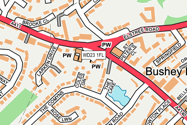
WD23 1FL is located in the Bushey Heath electoral ward, within the local authority district of Hertsmere and the English Parliamentary constituency of Hertsmere. The Sub Integrated Care Board (ICB) Location is NHS Hertfordshire and West Essex ICB - 06N and the police force is Hertfordshire. This postcode has been in use since July 2012.


GetTheData
Source: OS OpenMap – Local (Ordnance Survey)
Source: OS VectorMap District (Ordnance Survey)
Licence: Open Government Licence (requires attribution)
| Easting | 514473 |
| Northing | 194398 |
| Latitude | 51.636750 |
| Longitude | -0.347274 |
GetTheData
Source: Open Postcode Geo
Licence: Open Government Licence
| Country | England |
| Postcode District | WD23 |
➜ See where WD23 is on a map ➜ Where is Bushey? | |
GetTheData
Source: Land Registry Price Paid Data
Licence: Open Government Licence
Elevation or altitude of WD23 1FL as distance above sea level:
| Metres | Feet | |
|---|---|---|
| Elevation | 140m | 459ft |
Elevation is measured from the approximate centre of the postcode, to the nearest point on an OS contour line from OS Terrain 50, which has contour spacing of ten vertical metres.
➜ How high above sea level am I? Find the elevation of your current position using your device's GPS.
GetTheData
Source: Open Postcode Elevation
Licence: Open Government Licence
| Ward | Bushey Heath |
| Constituency | Hertsmere |
GetTheData
Source: ONS Postcode Database
Licence: Open Government Licence
| Three Crowns Ph (Sparrows Herne) | Bushey | 66m |
| Three Crowns Ph (Elstree Road) | Bushey | 69m |
| St Peter's Close (High Road) | Bushey | 174m |
| Merry Hill Road (Sparrows Herne) | Bushey Heath | 246m |
| Springfield (Elstree Road) | Bushey Heath | 297m |
| Bushey Station | 2.8km |
| Carpenders Park Station | 2.8km |
| Hatch End Station | 3.4km |
GetTheData
Source: NaPTAN
Licence: Open Government Licence
GetTheData
Source: ONS Postcode Database
Licence: Open Government Licence


➜ Get more ratings from the Food Standards Agency
GetTheData
Source: Food Standards Agency
Licence: FSA terms & conditions
| Last Collection | |||
|---|---|---|---|
| Location | Mon-Fri | Sat | Distance |
| Bushey Heath P.o | 19:00 | 12:00 | 348m |
| The Common | 18:00 | 13:00 | 1,047m |
| Bushey P.o | 18:30 | 12:00 | 1,532m |
GetTheData
Source: Dracos
Licence: Creative Commons Attribution-ShareAlike
The below table lists the International Territorial Level (ITL) codes (formerly Nomenclature of Territorial Units for Statistics (NUTS) codes) and Local Administrative Units (LAU) codes for WD23 1FL:
| ITL 1 Code | Name |
|---|---|
| TLH | East |
| ITL 2 Code | Name |
| TLH2 | Bedfordshire and Hertfordshire |
| ITL 3 Code | Name |
| TLH23 | Hertfordshire CC |
| LAU 1 Code | Name |
| E07000098 | Hertsmere |
GetTheData
Source: ONS Postcode Directory
Licence: Open Government Licence
The below table lists the Census Output Area (OA), Lower Layer Super Output Area (LSOA), and Middle Layer Super Output Area (MSOA) for WD23 1FL:
| Code | Name | |
|---|---|---|
| OA | E00119619 | |
| LSOA | E01023550 | Hertsmere 013C |
| MSOA | E02004908 | Hertsmere 013 |
GetTheData
Source: ONS Postcode Directory
Licence: Open Government Licence
| WD23 1AJ | Sparrows Herne | 33m |
| WD23 1HR | Coles Green | 40m |
| WD23 1HS | The Lake | 62m |
| WD23 1EA | High Road | 73m |
| WD23 4XF | Herne Court | 86m |
| WD23 1EF | Sparrows Herne | 94m |
| WD23 1FE | Sparrows Wick | 105m |
| WD23 1HN | The Comyns | 115m |
| WD23 4LQ | Richfield Road | 126m |
| WD23 1FG | St Peters Close | 127m |
GetTheData
Source: Open Postcode Geo; Land Registry Price Paid Data
Licence: Open Government Licence