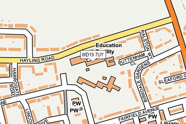
WD19 7UY is located in the Oxhey Hall & Hayling electoral ward, within the local authority district of Three Rivers and the English Parliamentary constituency of South West Hertfordshire. The Sub Integrated Care Board (ICB) Location is NHS Hertfordshire and West Essex ICB - 06N and the police force is Hertfordshire. This postcode has been in use since December 2000.


GetTheData
Source: OS OpenMap – Local (Ordnance Survey)
Source: OS VectorMap District (Ordnance Survey)
Licence: Open Government Licence (requires attribution)
| Easting | 511406 |
| Northing | 193498 |
| Latitude | 51.629276 |
| Longitude | -0.391859 |
GetTheData
Source: Open Postcode Geo
Licence: Open Government Licence
| Country | England |
| Postcode District | WD19 |
➜ See where WD19 is on a map ➜ Where is Watford? | |
GetTheData
Source: Land Registry Price Paid Data
Licence: Open Government Licence
Elevation or altitude of WD19 7UY as distance above sea level:
| Metres | Feet | |
|---|---|---|
| Elevation | 70m | 230ft |
Elevation is measured from the approximate centre of the postcode, to the nearest point on an OS contour line from OS Terrain 50, which has contour spacing of ten vertical metres.
➜ How high above sea level am I? Find the elevation of your current position using your device's GPS.
GetTheData
Source: Open Postcode Elevation
Licence: Open Government Licence
| Ward | Oxhey Hall & Hayling |
| Constituency | South West Hertfordshire |
GetTheData
Source: ONS Postcode Database
Licence: Open Government Licence
| Colnbrook School (Hayling Road) | South Oxhey | 70m |
| Colnbrook School (Hayling Road) | South Oxhey | 111m |
| Fairfield Avenue | South Oxhey | 149m |
| Fairfield Avenue (Gosforth Lane) | South Oxhey | 188m |
| Lincoln Drive (Gosforth Lane) | South Oxhey | 195m |
| Carpenders Park Station | 0.4km |
| Bushey Station | 1.9km |
| Watford High Street Station | 2.6km |
GetTheData
Source: NaPTAN
Licence: Open Government Licence
GetTheData
Source: ONS Postcode Database
Licence: Open Government Licence


➜ Get more ratings from the Food Standards Agency
GetTheData
Source: Food Standards Agency
Licence: FSA terms & conditions
| Last Collection | |||
|---|---|---|---|
| Location | Mon-Fri | Sat | Distance |
| Prestwick Road P.o | 18:30 | 12:00 | 471m |
| Carpenders Park P.o | 18:30 | 12:00 | 602m |
| By The Wood | 17:30 | 12:00 | 661m |
GetTheData
Source: Dracos
Licence: Creative Commons Attribution-ShareAlike
The below table lists the International Territorial Level (ITL) codes (formerly Nomenclature of Territorial Units for Statistics (NUTS) codes) and Local Administrative Units (LAU) codes for WD19 7UY:
| ITL 1 Code | Name |
|---|---|
| TLH | East |
| ITL 2 Code | Name |
| TLH2 | Bedfordshire and Hertfordshire |
| ITL 3 Code | Name |
| TLH23 | Hertfordshire CC |
| LAU 1 Code | Name |
| E07000102 | Three Rivers |
GetTheData
Source: ONS Postcode Directory
Licence: Open Government Licence
The below table lists the Census Output Area (OA), Lower Layer Super Output Area (LSOA), and Middle Layer Super Output Area (MSOA) for WD19 7UY:
| Code | Name | |
|---|---|---|
| OA | E00120996 | |
| LSOA | E01023828 | Three Rivers 008B |
| MSOA | E02004963 | Three Rivers 008 |
GetTheData
Source: ONS Postcode Directory
Licence: Open Government Licence
| WD19 7BN | Hayling Road | 88m |
| WD19 7BW | Hayling Road | 94m |
| WD19 7BJ | Puttenham Close | 113m |
| WD19 7DS | Swanston Path | 125m |
| WD19 7AW | Birkdale Gardens | 141m |
| WD19 7AU | Gosforth Lane | 176m |
| WD19 7DR | Buxton Path | 180m |
| WD19 7AR | Fairfield Avenue | 183m |
| WD19 7AZ | Gosforth Lane | 186m |
| WD19 7AL | Birkdale Gardens | 187m |
GetTheData
Source: Open Postcode Geo; Land Registry Price Paid Data
Licence: Open Government Licence