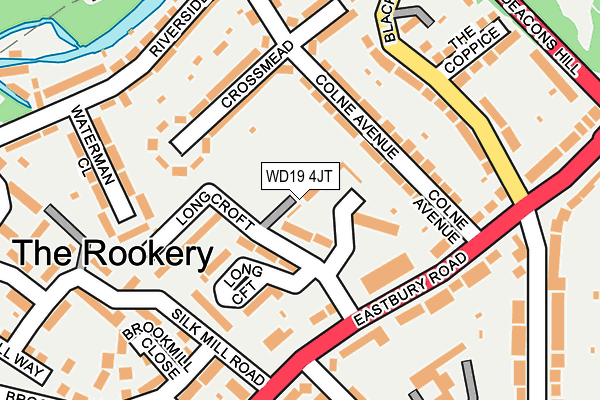
WD19 4JT is located in the Oxhey electoral ward, within the local authority district of Watford and the English Parliamentary constituency of Watford. The Sub Integrated Care Board (ICB) Location is NHS Hertfordshire and West Essex ICB - 06N and the police force is Hertfordshire. This postcode has been in use since October 2000.


GetTheData
Source: OS OpenMap – Local (Ordnance Survey)
Source: OS VectorMap District (Ordnance Survey)
Licence: Open Government Licence (requires attribution)
| Easting | 510971 |
| Northing | 194986 |
| Latitude | 51.642736 |
| Longitude | -0.397670 |
GetTheData
Source: Open Postcode Geo
Licence: Open Government Licence
| Country | England |
| Postcode District | WD19 |
➜ See where WD19 is on a map ➜ Where is Watford? | |
GetTheData
Source: Land Registry Price Paid Data
Licence: Open Government Licence
Elevation or altitude of WD19 4JT as distance above sea level:
| Metres | Feet | |
|---|---|---|
| Elevation | 60m | 197ft |
Elevation is measured from the approximate centre of the postcode, to the nearest point on an OS contour line from OS Terrain 50, which has contour spacing of ten vertical metres.
➜ How high above sea level am I? Find the elevation of your current position using your device's GPS.
GetTheData
Source: Open Postcode Elevation
Licence: Open Government Licence
| Ward | Oxhey |
| Constituency | Watford |
GetTheData
Source: ONS Postcode Database
Licence: Open Government Licence
| Long Croft (Eastbury Road) | Oxhey | 126m |
| Silk Mill Road | Oxhey | 169m |
| Waterman Close (Riverside Road) | Oxhey | 234m |
| Deacons Hill (Eastbury Road) | Oxhey | 261m |
| Waterman Close (Riverside Road) | Oxhey | 262m |
| Bushey Station | 0.9km |
| Watford High Street Station | 1.2km |
| Carpenders Park Station | 1.8km |
GetTheData
Source: NaPTAN
Licence: Open Government Licence
| Percentage of properties with Next Generation Access | 100.0% |
| Percentage of properties with Superfast Broadband | 100.0% |
| Percentage of properties with Ultrafast Broadband | 100.0% |
| Percentage of properties with Full Fibre Broadband | 0.0% |
Superfast Broadband is between 30Mbps and 300Mbps
Ultrafast Broadband is > 300Mbps
| Median download speed | 11.8Mbps |
| Average download speed | 37.0Mbps |
| Maximum download speed | 100.00Mbps |
| Median upload speed | 1.1Mbps |
| Average upload speed | 5.2Mbps |
| Maximum upload speed | 19.53Mbps |
| Percentage of properties unable to receive 2Mbps | 0.0% |
| Percentage of properties unable to receive 5Mbps | 0.0% |
| Percentage of properties unable to receive 10Mbps | 0.0% |
| Percentage of properties unable to receive 30Mbps | 0.0% |
GetTheData
Source: Ofcom
Licence: Ofcom Terms of Use (requires attribution)
Estimated total energy consumption in WD19 4JT by fuel type, 2015.
| Consumption (kWh) | 198,708 |
|---|---|
| Meter count | 32 |
| Mean (kWh/meter) | 6,210 |
| Median (kWh/meter) | 6,098 |
| Consumption (kWh) | 45,957 |
|---|---|
| Meter count | 28 |
| Mean (kWh/meter) | 1,641 |
| Median (kWh/meter) | 1,542 |
GetTheData
Source: Postcode level gas estimates: 2015 (experimental)
Source: Postcode level electricity estimates: 2015 (experimental)
Licence: Open Government Licence
GetTheData
Source: ONS Postcode Database
Licence: Open Government Licence

➜ Get more ratings from the Food Standards Agency
GetTheData
Source: Food Standards Agency
Licence: FSA terms & conditions
| Last Collection | |||
|---|---|---|---|
| Location | Mon-Fri | Sat | Distance |
| Eastbury Road P.o | 17:30 | 12:00 | 325m |
| Cardiff Road | 18:30 | 12:00 | 756m |
| Byewaters / Blackmore Lane | 17:30 | 11:45 | 921m |
GetTheData
Source: Dracos
Licence: Creative Commons Attribution-ShareAlike
The below table lists the International Territorial Level (ITL) codes (formerly Nomenclature of Territorial Units for Statistics (NUTS) codes) and Local Administrative Units (LAU) codes for WD19 4JT:
| ITL 1 Code | Name |
|---|---|
| TLH | East |
| ITL 2 Code | Name |
| TLH2 | Bedfordshire and Hertfordshire |
| ITL 3 Code | Name |
| TLH23 | Hertfordshire CC |
| LAU 1 Code | Name |
| E07000103 | Watford |
GetTheData
Source: ONS Postcode Directory
Licence: Open Government Licence
The below table lists the Census Output Area (OA), Lower Layer Super Output Area (LSOA), and Middle Layer Super Output Area (MSOA) for WD19 4JT:
| Code | Name | |
|---|---|---|
| OA | E00121280 | |
| LSOA | E01023883 | Watford 012B |
| MSOA | E02004979 | Watford 012 |
GetTheData
Source: ONS Postcode Directory
Licence: Open Government Licence
| WD19 4JE | Colne Avenue | 82m |
| WD19 4JL | Eastbury Road | 110m |
| WD19 4JF | Colne Avenue | 114m |
| WD19 4JU | Longcroft | 117m |
| WD19 4JQ | Crossmead | 139m |
| WD19 4JN | Eastbury Road | 159m |
| WD19 4HW | Blackwell Drive | 164m |
| WD19 4HX | Riverside Road | 197m |
| WD19 4JG | Crossmead | 198m |
| WD19 4JD | Waterman Close | 207m |
GetTheData
Source: Open Postcode Geo; Land Registry Price Paid Data
Licence: Open Government Licence