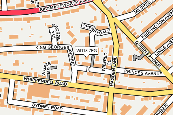
WD18 7EG lies on Neilson Close in Watford. WD18 7EG is located in the Holywell electoral ward, within the local authority district of Watford and the English Parliamentary constituency of Watford. The Sub Integrated Care Board (ICB) Location is NHS Hertfordshire and West Essex ICB - 06N and the police force is Hertfordshire. This postcode has been in use since March 2016.


GetTheData
Source: OS OpenMap – Local (Ordnance Survey)
Source: OS VectorMap District (Ordnance Survey)
Licence: Open Government Licence (requires attribution)
| Easting | 509674 |
| Northing | 195978 |
| Latitude | 51.651911 |
| Longitude | -0.416073 |
GetTheData
Source: Open Postcode Geo
Licence: Open Government Licence
| Street | Neilson Close |
| Town/City | Watford |
| Country | England |
| Postcode District | WD18 |
➜ See where WD18 is on a map ➜ Where is Watford? | |
GetTheData
Source: Land Registry Price Paid Data
Licence: Open Government Licence
Elevation or altitude of WD18 7EG as distance above sea level:
| Metres | Feet | |
|---|---|---|
| Elevation | 70m | 230ft |
Elevation is measured from the approximate centre of the postcode, to the nearest point on an OS contour line from OS Terrain 50, which has contour spacing of ten vertical metres.
➜ How high above sea level am I? Find the elevation of your current position using your device's GPS.
GetTheData
Source: Open Postcode Elevation
Licence: Open Government Licence
| Ward | Holywell |
| Constituency | Watford |
GetTheData
Source: ONS Postcode Database
Licence: Open Government Licence
| Hagden Lane (Whippendell Road) | Watford | 96m |
| Hagden Lane (Whippendell Road) | Watford | 122m |
| Metropolitan Station Approach (Rickmansworth Road) | Watford | 188m |
| Metropolitan Station Approach (Rickmansworth Road) | Watford | 244m |
| Sydney Road (Whippendell Road) | Watford | 250m |
| Watford Underground Station | Watford | 622m |
| Watford High Street Station | 1.7km |
| Watford Junction Station | 1.9km |
| Bushey Station | 2.2km |
GetTheData
Source: NaPTAN
Licence: Open Government Licence
| Percentage of properties with Next Generation Access | 100.0% |
| Percentage of properties with Superfast Broadband | 100.0% |
| Percentage of properties with Ultrafast Broadband | 0.0% |
| Percentage of properties with Full Fibre Broadband | 0.0% |
Superfast Broadband is between 30Mbps and 300Mbps
Ultrafast Broadband is > 300Mbps
| Median download speed | 70.7Mbps |
| Average download speed | 68.9Mbps |
| Maximum download speed | 79.91Mbps |
| Median upload speed | 19.9Mbps |
| Average upload speed | 18.6Mbps |
| Maximum upload speed | 20.00Mbps |
| Percentage of properties unable to receive 2Mbps | 0.0% |
| Percentage of properties unable to receive 5Mbps | 0.0% |
| Percentage of properties unable to receive 10Mbps | 0.0% |
| Percentage of properties unable to receive 30Mbps | 0.0% |
GetTheData
Source: Ofcom
Licence: Ofcom Terms of Use (requires attribution)
GetTheData
Source: ONS Postcode Database
Licence: Open Government Licence


➜ Get more ratings from the Food Standards Agency
GetTheData
Source: Food Standards Agency
Licence: FSA terms & conditions
| Last Collection | |||
|---|---|---|---|
| Location | Mon-Fri | Sat | Distance |
| Jellicoe Road | 18:30 | 12:00 | 568m |
| Hagden Lane | 18:30 | 12:00 | 614m |
| Byewaters / Blackmore Lane | 17:30 | 11:45 | 748m |
GetTheData
Source: Dracos
Licence: Creative Commons Attribution-ShareAlike
The below table lists the International Territorial Level (ITL) codes (formerly Nomenclature of Territorial Units for Statistics (NUTS) codes) and Local Administrative Units (LAU) codes for WD18 7EG:
| ITL 1 Code | Name |
|---|---|
| TLH | East |
| ITL 2 Code | Name |
| TLH2 | Bedfordshire and Hertfordshire |
| ITL 3 Code | Name |
| TLH23 | Hertfordshire CC |
| LAU 1 Code | Name |
| E07000103 | Watford |
GetTheData
Source: ONS Postcode Directory
Licence: Open Government Licence
The below table lists the Census Output Area (OA), Lower Layer Super Output Area (LSOA), and Middle Layer Super Output Area (MSOA) for WD18 7EG:
| Code | Name | |
|---|---|---|
| OA | E00121192 | |
| LSOA | E01023867 | Watford 011E |
| MSOA | E02004978 | Watford 011 |
GetTheData
Source: ONS Postcode Directory
Licence: Open Government Licence
| WD18 7EB | Rembrandt Way | 43m |
| WD18 7UN | Bramleas | 44m |
| WD18 7TD | Solar Court | 69m |
| WD18 7EF | Wilfred Close | 74m |
| WD18 7QP | Argyle Court | 91m |
| WD18 7SN | Hagden Lane | 91m |
| WD18 7UP | Oakhurst Place | 92m |
| WD18 7TA | King Georges Avenue | 107m |
| WD18 7UL | Cherrydale | 124m |
| WD18 7SH | Hagden Lane | 124m |
GetTheData
Source: Open Postcode Geo; Land Registry Price Paid Data
Licence: Open Government Licence