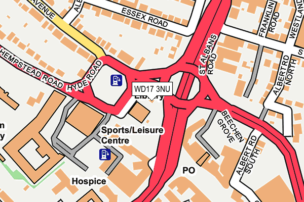
WD17 3NU is located in the Park electoral ward, within the local authority district of Watford and the English Parliamentary constituency of Watford. The Sub Integrated Care Board (ICB) Location is NHS Hertfordshire and West Essex ICB - 06N and the police force is Hertfordshire. This postcode has been in use since December 2000.


GetTheData
Source: OS OpenMap – Local (Ordnance Survey)
Source: OS VectorMap District (Ordnance Survey)
Licence: Open Government Licence (requires attribution)
| Easting | 510576 |
| Northing | 196957 |
| Latitude | 51.660528 |
| Longitude | -0.402753 |
GetTheData
Source: Open Postcode Geo
Licence: Open Government Licence
| Country | England |
| Postcode District | WD17 |
➜ See where WD17 is on a map ➜ Where is Watford? | |
GetTheData
Source: Land Registry Price Paid Data
Licence: Open Government Licence
Elevation or altitude of WD17 3NU as distance above sea level:
| Metres | Feet | |
|---|---|---|
| Elevation | 70m | 230ft |
Elevation is measured from the approximate centre of the postcode, to the nearest point on an OS contour line from OS Terrain 50, which has contour spacing of ten vertical metres.
➜ How high above sea level am I? Find the elevation of your current position using your device's GPS.
GetTheData
Source: Open Postcode Elevation
Licence: Open Government Licence
| Ward | Park |
| Constituency | Watford |
GetTheData
Source: ONS Postcode Database
Licence: Open Government Licence
| Town Hall (The Avenue) | Watford | 56m |
| Town Hall (Hempstead Road) | Watford | 60m |
| Town Hall (Rickmansworth Road) | Watford | 121m |
| Beechen Grove North | Watford | 140m |
| Alexandra Road (The Avenue) | Watford | 186m |
| Watford Underground Station | Watford | 1,068m |
| Watford Junction Station | 0.5km |
| Watford High Street Station | 1.2km |
| Watford North Station | 1.9km |
GetTheData
Source: NaPTAN
Licence: Open Government Licence
GetTheData
Source: ONS Postcode Database
Licence: Open Government Licence


➜ Get more ratings from the Food Standards Agency
GetTheData
Source: Food Standards Agency
Licence: FSA terms & conditions
| Last Collection | |||
|---|---|---|---|
| Location | Mon-Fri | Sat | Distance |
| The Pond P.o | 19:00 | 12:00 | 136m |
| The Avenue | 18:30 | 12:00 | 252m |
| Cassiobury Drive | 18:30 | 12:00 | 462m |
GetTheData
Source: Dracos
Licence: Creative Commons Attribution-ShareAlike
The below table lists the International Territorial Level (ITL) codes (formerly Nomenclature of Territorial Units for Statistics (NUTS) codes) and Local Administrative Units (LAU) codes for WD17 3NU:
| ITL 1 Code | Name |
|---|---|
| TLH | East |
| ITL 2 Code | Name |
| TLH2 | Bedfordshire and Hertfordshire |
| ITL 3 Code | Name |
| TLH23 | Hertfordshire CC |
| LAU 1 Code | Name |
| E07000103 | Watford |
GetTheData
Source: ONS Postcode Directory
Licence: Open Government Licence
The below table lists the Census Output Area (OA), Lower Layer Super Output Area (LSOA), and Middle Layer Super Output Area (MSOA) for WD17 3NU:
| Code | Name | |
|---|---|---|
| OA | E00121309 | |
| LSOA | E01023888 | Watford 008C |
| MSOA | E02004975 | Watford 008 |
GetTheData
Source: ONS Postcode Directory
Licence: Open Government Licence
| WD17 4NR | The Avenue | 100m |
| WD17 3EX | Water Lane | 119m |
| WD17 4EP | Essex Road | 139m |
| WD17 4NS | The Avenue | 141m |
| WD17 1NA | The Parade | 159m |
| WD17 1BN | St Albans Road | 161m |
| WD17 1BQ | St Albans Road | 161m |
| WD17 1BD | The Parade | 183m |
| WD17 1BA | The Parade | 184m |
| WD17 4EL | Essex Road | 187m |
GetTheData
Source: Open Postcode Geo; Land Registry Price Paid Data
Licence: Open Government Licence