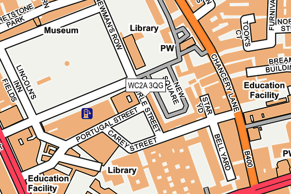
WC2A 3QG is located in the Holborn & Covent Garden electoral ward, within the London borough of Camden and the English Parliamentary constituency of Holborn and St Pancras. The Sub Integrated Care Board (ICB) Location is NHS North Central London ICB - 93C and the police force is Metropolitan Police. This postcode has been in use since January 1980.


GetTheData
Source: OS OpenMap – Local (Ordnance Survey)
Source: OS VectorMap District (Ordnance Survey)
Licence: Open Government Licence (requires attribution)
| Easting | 530944 |
| Northing | 181315 |
| Latitude | 51.515590 |
| Longitude | -0.114273 |
GetTheData
Source: Open Postcode Geo
Licence: Open Government Licence
| Country | England |
| Postcode District | WC2A |
➜ See where WC2A is on a map ➜ Where is City of Westminster? | |
GetTheData
Source: Land Registry Price Paid Data
Licence: Open Government Licence
Elevation or altitude of WC2A 3QG as distance above sea level:
| Metres | Feet | |
|---|---|---|
| Elevation | 20m | 66ft |
Elevation is measured from the approximate centre of the postcode, to the nearest point on an OS contour line from OS Terrain 50, which has contour spacing of ten vertical metres.
➜ How high above sea level am I? Find the elevation of your current position using your device's GPS.
GetTheData
Source: Open Postcode Elevation
Licence: Open Government Licence
| Ward | Holborn & Covent Garden |
| Constituency | Holborn And St Pancras |
GetTheData
Source: ONS Postcode Database
Licence: Open Government Licence
| The Royal Courts Of Justice | Temple | 253m |
| The Royal Courts Of Justice (Strand) | Temple | 267m |
| Brownlow Street (High Holborn) | Holborn | 281m |
| Aldwych Royal Cts Of Justice | Temple | 284m |
| Brownlow Street (High Holborn) | Holborn | 297m |
| Chancery Lane Underground Station | Chancery Lane | 349m |
| Holborn Underground Station | Holborn | 484m |
| Temple Underground Station | Temple | 510m |
| Covent Garden Underground Station | Covent Garden | 758m |
| Farringdon Underground Station | Farringdon | 831m |
| City Thameslink Station | 0.8km |
| Farringdon (London) Station | 0.8km |
| London Blackfriars Station | 0.9km |
GetTheData
Source: NaPTAN
Licence: Open Government Licence
GetTheData
Source: ONS Postcode Database
Licence: Open Government Licence


➜ Get more ratings from the Food Standards Agency
GetTheData
Source: Food Standards Agency
Licence: FSA terms & conditions
| Last Collection | |||
|---|---|---|---|
| Location | Mon-Fri | Sat | Distance |
| Carey Street (Serle St) | 18:30 | 12:00 | 89m |
| New Square | 18:30 | 12:00 | 89m |
| Chancery Lane (Opp Rolls Pass) | 18:30 | 12:00 | 161m |
GetTheData
Source: Dracos
Licence: Creative Commons Attribution-ShareAlike
The below table lists the International Territorial Level (ITL) codes (formerly Nomenclature of Territorial Units for Statistics (NUTS) codes) and Local Administrative Units (LAU) codes for WC2A 3QG:
| ITL 1 Code | Name |
|---|---|
| TLI | London |
| ITL 2 Code | Name |
| TLI3 | Inner London - West |
| ITL 3 Code | Name |
| TLI31 | Camden and City of London |
| LAU 1 Code | Name |
| E09000007 | Camden |
GetTheData
Source: ONS Postcode Directory
Licence: Open Government Licence
The below table lists the Census Output Area (OA), Lower Layer Super Output Area (LSOA), and Middle Layer Super Output Area (MSOA) for WC2A 3QG:
| Code | Name | |
|---|---|---|
| OA | E00004524 | |
| LSOA | E01000914 | Camden 028B |
| MSOA | E02000193 | Camden 028 |
GetTheData
Source: ONS Postcode Directory
Licence: Open Government Licence
| WC2A 3QS | New Square | 77m |
| WC2A 1EG | Chichester Rents | 125m |
| WC2A 1ET | Chancery Lane | 148m |
| WC2A 3LY | Lincolns Inn Fields | 192m |
| WC2A 1LS | Chancery Lane | 194m |
| WC2A 2JR | Bell Yard | 213m |
| EC4A 1DT | Breams Buildings | 215m |
| WC2A 3AB | Whetstone Park | 251m |
| EC4A 1LB | Tooks Court | 258m |
| WC1V 7HH | Great Turnstile | 264m |
GetTheData
Source: Open Postcode Geo; Land Registry Price Paid Data
Licence: Open Government Licence