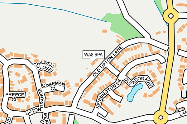
WA8 9PA lies on Old Upton Lane in Widnes. WA8 9PA is located in the Birchfield electoral ward, within the unitary authority of Halton and the English Parliamentary constituency of Halton. The Sub Integrated Care Board (ICB) Location is NHS Cheshire and Merseyside ICB - 01F and the police force is Cheshire. This postcode has been in use since January 1980.


GetTheData
Source: OS OpenMap – Local (Ordnance Survey)
Source: OS VectorMap District (Ordnance Survey)
Licence: Open Government Licence (requires attribution)
| Easting | 350052 |
| Northing | 387595 |
| Latitude | 53.382827 |
| Longitude | -2.752374 |
GetTheData
Source: Open Postcode Geo
Licence: Open Government Licence
| Street | Old Upton Lane |
| Town/City | Widnes |
| Country | England |
| Postcode District | WA8 |
➜ See where WA8 is on a map ➜ Where is Widnes? | |
GetTheData
Source: Land Registry Price Paid Data
Licence: Open Government Licence
Elevation or altitude of WA8 9PA as distance above sea level:
| Metres | Feet | |
|---|---|---|
| Elevation | 30m | 98ft |
Elevation is measured from the approximate centre of the postcode, to the nearest point on an OS contour line from OS Terrain 50, which has contour spacing of ten vertical metres.
➜ How high above sea level am I? Find the elevation of your current position using your device's GPS.
GetTheData
Source: Open Postcode Elevation
Licence: Open Government Licence
| Ward | Birchfield |
| Constituency | Halton |
GetTheData
Source: ONS Postcode Database
Licence: Open Government Licence
99, OLD UPTON LANE, WIDNES, WA8 9PA 2020 17 SEP £225,000 |
UPTON LODGE, 139, OLD UPTON LANE, WIDNES, WA8 9PA 2010 10 DEC £300,000 |
GetTheData
Source: HM Land Registry Price Paid Data
Licence: Contains HM Land Registry data © Crown copyright and database right 2025. This data is licensed under the Open Government Licence v3.0.
| Queensbury Way | Upton Rocks | 227m |
| Queensbury Way | Upton Rocks | 510m |
| Queensbury Way | Upton Rocks | 585m |
| Four Topped Oak (Hough Green Road) | Upton | 770m |
| County Boundary (Cronton Road) | Cronton | 786m |
| Widnes Station | 1.3km |
| Hough Green Station | 1.9km |
| Rainhill Station | 3.9km |
GetTheData
Source: NaPTAN
Licence: Open Government Licence
| Percentage of properties with Next Generation Access | 100.0% |
| Percentage of properties with Superfast Broadband | 100.0% |
| Percentage of properties with Ultrafast Broadband | 0.0% |
| Percentage of properties with Full Fibre Broadband | 0.0% |
Superfast Broadband is between 30Mbps and 300Mbps
Ultrafast Broadband is > 300Mbps
| Percentage of properties unable to receive 2Mbps | 0.0% |
| Percentage of properties unable to receive 5Mbps | 0.0% |
| Percentage of properties unable to receive 10Mbps | 0.0% |
| Percentage of properties unable to receive 30Mbps | 0.0% |
GetTheData
Source: Ofcom
Licence: Ofcom Terms of Use (requires attribution)
GetTheData
Source: ONS Postcode Database
Licence: Open Government Licence


➜ Get more ratings from the Food Standards Agency
GetTheData
Source: Food Standards Agency
Licence: FSA terms & conditions
| Last Collection | |||
|---|---|---|---|
| Location | Mon-Fri | Sat | Distance |
| Blackhorse Post Office | 18:00 | 12:00 | 1,210m |
| Beaconsfield | 17:15 | 11:00 | 1,532m |
| Farnworth S.o. | 17:15 | 12:00 | 1,768m |
GetTheData
Source: Dracos
Licence: Creative Commons Attribution-ShareAlike
The below table lists the International Territorial Level (ITL) codes (formerly Nomenclature of Territorial Units for Statistics (NUTS) codes) and Local Administrative Units (LAU) codes for WA8 9PA:
| ITL 1 Code | Name |
|---|---|
| TLD | North West (England) |
| ITL 2 Code | Name |
| TLD7 | Merseyside |
| ITL 3 Code | Name |
| TLD71 | East Merseyside |
| LAU 1 Code | Name |
| E06000006 | Halton |
GetTheData
Source: ONS Postcode Directory
Licence: Open Government Licence
The below table lists the Census Output Area (OA), Lower Layer Super Output Area (LSOA), and Middle Layer Super Output Area (MSOA) for WA8 9PA:
| Code | Name | |
|---|---|---|
| OA | E00170562 | |
| LSOA | E01012374 | Halton 002A |
| MSOA | E02002575 | Halton 002 |
GetTheData
Source: ONS Postcode Directory
Licence: Open Government Licence
| WA8 9PG | Marsden Court | 68m |
| WA8 9ZS | Old Upton Lane | 77m |
| WA8 9PE | Kennington Park | 127m |
| WA8 9WU | Chapman Close | 130m |
| WA8 9PF | Harton Close | 139m |
| WA8 9NY | Chilwell Close | 140m |
| WA8 9PD | Cleadon Way | 155m |
| WA8 9ZB | Upton Grange | 212m |
| WA8 9WQ | Preece Close | 241m |
| WA8 9GL | Bowen Close | 244m |
GetTheData
Source: Open Postcode Geo; Land Registry Price Paid Data
Licence: Open Government Licence