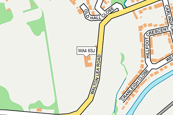
WA4 6SJ is located in the Appleton electoral ward, within the unitary authority of Warrington and the English Parliamentary constituency of Warrington South. The Sub Integrated Care Board (ICB) Location is NHS Cheshire and Merseyside ICB - 02E and the police force is Cheshire. This postcode has been in use since January 1980.


GetTheData
Source: OS OpenMap – Local (Ordnance Survey)
Source: OS VectorMap District (Ordnance Survey)
Licence: Open Government Licence (requires attribution)
| Easting | 360438 |
| Northing | 385378 |
| Latitude | 53.363783 |
| Longitude | -2.595964 |
GetTheData
Source: Open Postcode Geo
Licence: Open Government Licence
| Country | England |
| Postcode District | WA4 |
➜ See where WA4 is on a map | |
GetTheData
Source: Land Registry Price Paid Data
Licence: Open Government Licence
Elevation or altitude of WA4 6SJ as distance above sea level:
| Metres | Feet | |
|---|---|---|
| Elevation | 20m | 66ft |
Elevation is measured from the approximate centre of the postcode, to the nearest point on an OS contour line from OS Terrain 50, which has contour spacing of ten vertical metres.
➜ How high above sea level am I? Find the elevation of your current position using your device's GPS.
GetTheData
Source: Open Postcode Elevation
Licence: Open Government Licence
| Ward | Appleton |
| Constituency | Warrington South |
GetTheData
Source: ONS Postcode Database
Licence: Open Government Licence
| Granby Road (Walton Lea Road) | Walton | 404m |
| Red Lane (Whitefield Road) | Walton | 586m |
| Stag Inn (Chester Road) | Walton | 613m |
| Stag Inn (Hill Cliffe Road) | Walton | 613m |
| Stag Inn (Hill Cliffe Road) | Walton | 650m |
| Warrington Bank Quay Station | 2.5km |
| Warrington Central Station | 3.1km |
| Sankey for Penketh Station | 4.8km |
GetTheData
Source: NaPTAN
Licence: Open Government Licence
GetTheData
Source: ONS Postcode Database
Licence: Open Government Licence


➜ Get more ratings from the Food Standards Agency
GetTheData
Source: Food Standards Agency
Licence: FSA terms & conditions
| Last Collection | |||
|---|---|---|---|
| Location | Mon-Fri | Sat | Distance |
| Whitefield Road | 17:30 | 11:00 | 495m |
| Walton Road | 17:30 | 11:00 | 602m |
| Higher Walton | 17:30 | 09:00 | 773m |
GetTheData
Source: Dracos
Licence: Creative Commons Attribution-ShareAlike
The below table lists the International Territorial Level (ITL) codes (formerly Nomenclature of Territorial Units for Statistics (NUTS) codes) and Local Administrative Units (LAU) codes for WA4 6SJ:
| ITL 1 Code | Name |
|---|---|
| TLD | North West (England) |
| ITL 2 Code | Name |
| TLD6 | Cheshire |
| ITL 3 Code | Name |
| TLD61 | Warrington |
| LAU 1 Code | Name |
| E06000007 | Warrington |
GetTheData
Source: ONS Postcode Directory
Licence: Open Government Licence
The below table lists the Census Output Area (OA), Lower Layer Super Output Area (LSOA), and Middle Layer Super Output Area (MSOA) for WA4 6SJ:
| Code | Name | |
|---|---|---|
| OA | E00063055 | |
| LSOA | E01012502 | Warrington 024C |
| MSOA | E02002613 | Warrington 024 |
GetTheData
Source: ONS Postcode Directory
Licence: Open Government Licence
| WA4 6SZ | Old Hall Close | 193m |
| WA4 6SD | Cranleigh Close | 207m |
| WA4 6SB | Hillfoot Crescent | 226m |
| WA4 6SL | Walton Lea Road | 252m |
| WA4 6NE | Whitefield Road | 282m |
| WA4 6SA | Carlingford Road | 330m |
| WA4 6TB | Chester Road | 336m |
| WA4 6NY | Brookwood Close | 369m |
| WA4 6SF | Cambridge Close | 380m |
| WA4 6NZ | Hill Cliffe Road | 388m |
GetTheData
Source: Open Postcode Geo; Land Registry Price Paid Data
Licence: Open Government Licence