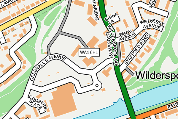
WA4 6HL is located in the Latchford West electoral ward, within the unitary authority of Warrington and the English Parliamentary constituency of Warrington South. The Sub Integrated Care Board (ICB) Location is NHS Cheshire and Merseyside ICB - 02E and the police force is Cheshire. This postcode has been in use since December 1998.


GetTheData
Source: OS OpenMap – Local (Ordnance Survey)
Source: OS VectorMap District (Ordnance Survey)
Licence: Open Government Licence (requires attribution)
| Easting | 361219 |
| Northing | 386593 |
| Latitude | 53.374761 |
| Longitude | -2.584378 |
GetTheData
Source: Open Postcode Geo
Licence: Open Government Licence
| Country | England |
| Postcode District | WA4 |
➜ See where WA4 is on a map ➜ Where is Warrington? | |
GetTheData
Source: Land Registry Price Paid Data
Licence: Open Government Licence
Elevation or altitude of WA4 6HL as distance above sea level:
| Metres | Feet | |
|---|---|---|
| Elevation | 10m | 33ft |
Elevation is measured from the approximate centre of the postcode, to the nearest point on an OS contour line from OS Terrain 50, which has contour spacing of ten vertical metres.
➜ How high above sea level am I? Find the elevation of your current position using your device's GPS.
GetTheData
Source: Open Postcode Elevation
Licence: Open Government Licence
| Ward | Latchford West |
| Constituency | Warrington South |
GetTheData
Source: ONS Postcode Database
Licence: Open Government Licence
| Morrisons (Wilderspool Causeway) | Wilderspool | 101m |
| Morrisons (Wilderspool Causeway) | Wilderspool | 102m |
| Burgess Avenue (Gainsborough Road) | Wilderspool | 231m |
| Swing Bridge (Ellesmere Road) | Wilderspool | 237m |
| Loushers Lane (Wilderspool Causeway) | Wilderspool | 245m |
| Warrington Bank Quay Station | 1.7km |
| Warrington Central Station | 2km |
| Padgate Station | 3.9km |
GetTheData
Source: NaPTAN
Licence: Open Government Licence
| Median download speed | 73.7Mbps |
| Average download speed | 65.7Mbps |
| Maximum download speed | 80.00Mbps |
| Median upload speed | 20.0Mbps |
| Average upload speed | 16.2Mbps |
| Maximum upload speed | 20.00Mbps |
GetTheData
Source: Ofcom
Licence: Ofcom Terms of Use (requires attribution)
GetTheData
Source: ONS Postcode Database
Licence: Open Government Licence


➜ Get more ratings from the Food Standards Agency
GetTheData
Source: Food Standards Agency
Licence: FSA terms & conditions
| Last Collection | |||
|---|---|---|---|
| Location | Mon-Fri | Sat | Distance |
| Greenalls Avenue | 17:30 | 11:00 | 115m |
| Ellesmere Road | 17:30 | 11:00 | 302m |
| Stockton Heath So | 17:30 | 12:00 | 414m |
GetTheData
Source: Dracos
Licence: Creative Commons Attribution-ShareAlike
The below table lists the International Territorial Level (ITL) codes (formerly Nomenclature of Territorial Units for Statistics (NUTS) codes) and Local Administrative Units (LAU) codes for WA4 6HL:
| ITL 1 Code | Name |
|---|---|
| TLD | North West (England) |
| ITL 2 Code | Name |
| TLD6 | Cheshire |
| ITL 3 Code | Name |
| TLD61 | Warrington |
| LAU 1 Code | Name |
| E06000007 | Warrington |
GetTheData
Source: ONS Postcode Directory
Licence: Open Government Licence
The below table lists the Census Output Area (OA), Lower Layer Super Output Area (LSOA), and Middle Layer Super Output Area (MSOA) for WA4 6HL:
| Code | Name | |
|---|---|---|
| OA | E00173141 | |
| LSOA | E01012509 | Warrington 018D |
| MSOA | E02002607 | Warrington 018 |
GetTheData
Source: ONS Postcode Directory
Licence: Open Government Licence
| WA4 6BG | Elphins Drive | 107m |
| WA4 6FZ | Elphins Drive | 130m |
| WA4 6RS | Wilderspool Causeway | 142m |
| WA4 6FW | Wade Avenue | 151m |
| WA4 6RT | China Lane | 165m |
| WA4 6DP | Elphins Drive | 169m |
| WA4 6RP | Stafford Road | 171m |
| WA4 6DU | Elphins Drive | 193m |
| WA4 6RU | Wilderspool Causeway | 218m |
| WA4 6NN | Coopers Place | 219m |
GetTheData
Source: Open Postcode Geo; Land Registry Price Paid Data
Licence: Open Government Licence