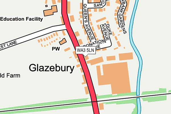
WA3 5LN lies on Warrington Road in Glazebury, Warrington. WA3 5LN is located in the Culcheth, Glazebury and Croft electoral ward, within the unitary authority of Warrington and the English Parliamentary constituency of Warrington North. The Sub Integrated Care Board (ICB) Location is NHS Cheshire and Merseyside ICB - 02E and the police force is Cheshire. This postcode has been in use since January 1980.


GetTheData
Source: OS OpenMap – Local (Ordnance Survey)
Source: OS VectorMap District (Ordnance Survey)
Licence: Open Government Licence (requires attribution)
| Easting | 367306 |
| Northing | 397048 |
| Latitude | 53.469146 |
| Longitude | -2.493978 |
GetTheData
Source: Open Postcode Geo
Licence: Open Government Licence
| Street | Warrington Road |
| Locality | Glazebury |
| Town/City | Warrington |
| Country | England |
| Postcode District | WA3 |
➜ See where WA3 is on a map ➜ Where is Glazebury? | |
GetTheData
Source: Land Registry Price Paid Data
Licence: Open Government Licence
Elevation or altitude of WA3 5LN as distance above sea level:
| Metres | Feet | |
|---|---|---|
| Elevation | 20m | 66ft |
Elevation is measured from the approximate centre of the postcode, to the nearest point on an OS contour line from OS Terrain 50, which has contour spacing of ten vertical metres.
➜ How high above sea level am I? Find the elevation of your current position using your device's GPS.
GetTheData
Source: Open Postcode Elevation
Licence: Open Government Licence
| Ward | Culcheth, Glazebury And Croft |
| Constituency | Warrington North |
GetTheData
Source: ONS Postcode Database
Licence: Open Government Licence
| Coronation Avenue (Warrington Road) | Glazebury | 62m |
| Coronation Avenue (Warrington Road) | Glazebury | 111m |
| Sandfield Crescent | Glazebury | 260m |
| Queen's Avenue | Glazebury | 262m |
| Sandfield Crescent | Glazebury | 263m |
| Glazebrook Station | 5.1km |
| Irlam Station | 5.6km |
GetTheData
Source: NaPTAN
Licence: Open Government Licence
| Percentage of properties with Next Generation Access | 100.0% |
| Percentage of properties with Superfast Broadband | 100.0% |
| Percentage of properties with Ultrafast Broadband | 0.0% |
| Percentage of properties with Full Fibre Broadband | 0.0% |
Superfast Broadband is between 30Mbps and 300Mbps
Ultrafast Broadband is > 300Mbps
| Percentage of properties unable to receive 2Mbps | 0.0% |
| Percentage of properties unable to receive 5Mbps | 0.0% |
| Percentage of properties unable to receive 10Mbps | 0.0% |
| Percentage of properties unable to receive 30Mbps | 0.0% |
GetTheData
Source: Ofcom
Licence: Ofcom Terms of Use (requires attribution)
GetTheData
Source: ONS Postcode Database
Licence: Open Government Licence


➜ Get more ratings from the Food Standards Agency
GetTheData
Source: Food Standards Agency
Licence: FSA terms & conditions
| Last Collection | |||
|---|---|---|---|
| Location | Mon-Fri | Sat | Distance |
| Glazebury S.o. | 17:30 | 12:00 | 151m |
| Hurst Mill Avenue | 17:30 | 09:00 | 596m |
| Raven Inn | 17:30 | 09:00 | 978m |
GetTheData
Source: Dracos
Licence: Creative Commons Attribution-ShareAlike
The below table lists the International Territorial Level (ITL) codes (formerly Nomenclature of Territorial Units for Statistics (NUTS) codes) and Local Administrative Units (LAU) codes for WA3 5LN:
| ITL 1 Code | Name |
|---|---|
| TLD | North West (England) |
| ITL 2 Code | Name |
| TLD6 | Cheshire |
| ITL 3 Code | Name |
| TLD61 | Warrington |
| LAU 1 Code | Name |
| E06000007 | Warrington |
GetTheData
Source: ONS Postcode Directory
Licence: Open Government Licence
The below table lists the Census Output Area (OA), Lower Layer Super Output Area (LSOA), and Middle Layer Super Output Area (MSOA) for WA3 5LN:
| Code | Name | |
|---|---|---|
| OA | E00062922 | |
| LSOA | E01012476 | Warrington 001C |
| MSOA | E02002590 | Warrington 001 |
GetTheData
Source: ONS Postcode Directory
Licence: Open Government Licence
| WA3 5LW | Warrington Road | 46m |
| WA3 5NA | Warrington Road | 94m |
| WA3 5LR | Warrington Road | 110m |
| WA3 5NE | Queens Avenue | 122m |
| WA3 5PG | Albion Park | 123m |
| WA3 5ND | Duke Avenue | 126m |
| WA3 5LS | Hurst Lane | 145m |
| WA3 5LZ | Warrington Road | 158m |
| WA3 5LX | Meadowbank Gardens | 225m |
| WA3 5NQ | Whalley Avenue | 247m |
GetTheData
Source: Open Postcode Geo; Land Registry Price Paid Data
Licence: Open Government Licence