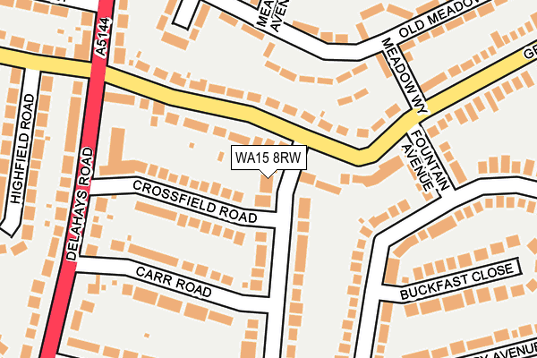
WA15 8RW lies on Carlton Road in Hale, Altrincham. WA15 8RW is located in the Hale Barns & Timperley South electoral ward, within the metropolitan district of Trafford and the English Parliamentary constituency of Altrincham and Sale West. The Sub Integrated Care Board (ICB) Location is NHS Greater Manchester ICB - 02A and the police force is Greater Manchester. This postcode has been in use since January 1980.


GetTheData
Source: OS OpenMap – Local (Ordnance Survey)
Source: OS VectorMap District (Ordnance Survey)
Licence: Open Government Licence (requires attribution)
| Easting | 378750 |
| Northing | 386975 |
| Latitude | 53.379195 |
| Longitude | -2.320903 |
GetTheData
Source: Open Postcode Geo
Licence: Open Government Licence
| Street | Carlton Road |
| Locality | Hale |
| Town/City | Altrincham |
| Country | England |
| Postcode District | WA15 |
➜ See where WA15 is on a map ➜ Where is Hale? | |
GetTheData
Source: Land Registry Price Paid Data
Licence: Open Government Licence
Elevation or altitude of WA15 8RW as distance above sea level:
| Metres | Feet | |
|---|---|---|
| Elevation | 50m | 164ft |
Elevation is measured from the approximate centre of the postcode, to the nearest point on an OS contour line from OS Terrain 50, which has contour spacing of ten vertical metres.
➜ How high above sea level am I? Find the elevation of your current position using your device's GPS.
GetTheData
Source: Open Postcode Elevation
Licence: Open Government Licence
| Ward | Hale Barns & Timperley South |
| Constituency | Altrincham And Sale West |
GetTheData
Source: ONS Postcode Database
Licence: Open Government Licence
2023 30 JAN £975,000 |
59, CARLTON ROAD, HALE, ALTRINCHAM, WA15 8RW 2021 31 MAR £650,000 |
2014 1 JUL £630,000 |
61, CARLTON ROAD, HALE, ALTRINCHAM, WA15 8RW 2014 28 MAR £500,000 |
2009 29 JUN £465,000 |
2006 28 MAR £458,000 |
1999 6 JUL £185,000 |
GetTheData
Source: HM Land Registry Price Paid Data
Licence: Contains HM Land Registry data © Crown copyright and database right 2025. This data is licensed under the Open Government Licence v3.0.
| Grove Lane/Delahays Road (Grove Lane) | Well Green | 153m |
| Grove Lane/Meadow Way (Grove Lane) | Well Green | 171m |
| Grove Lane/Meadow Way (Grove Lane) | Well Green | 184m |
| Grove Lane/Delahays Road (Grove Lane) | Well Green | 188m |
| Delahays Road/Carr Road (Delahays Road) | Well Green | 249m |
| Hale Station | 1.8km |
| Altrincham Station | 2km |
| Navigation Road Station | 2.3km |
GetTheData
Source: NaPTAN
Licence: Open Government Licence
| Percentage of properties with Next Generation Access | 100.0% |
| Percentage of properties with Superfast Broadband | 100.0% |
| Percentage of properties with Ultrafast Broadband | 0.0% |
| Percentage of properties with Full Fibre Broadband | 0.0% |
Superfast Broadband is between 30Mbps and 300Mbps
Ultrafast Broadband is > 300Mbps
| Percentage of properties unable to receive 2Mbps | 0.0% |
| Percentage of properties unable to receive 5Mbps | 0.0% |
| Percentage of properties unable to receive 10Mbps | 0.0% |
| Percentage of properties unable to receive 30Mbps | 0.0% |
GetTheData
Source: Ofcom
Licence: Ofcom Terms of Use (requires attribution)
GetTheData
Source: ONS Postcode Database
Licence: Open Government Licence


➜ Get more ratings from the Food Standards Agency
GetTheData
Source: Food Standards Agency
Licence: FSA terms & conditions
| Last Collection | |||
|---|---|---|---|
| Location | Mon-Fri | Sat | Distance |
| Grove Lane | 17:30 | 11:00 | 197m |
| Woburn Drive | 17:30 | 11:00 | 266m |
| Hale Road | 17:30 | 11:00 | 478m |
GetTheData
Source: Dracos
Licence: Creative Commons Attribution-ShareAlike
The below table lists the International Territorial Level (ITL) codes (formerly Nomenclature of Territorial Units for Statistics (NUTS) codes) and Local Administrative Units (LAU) codes for WA15 8RW:
| ITL 1 Code | Name |
|---|---|
| TLD | North West (England) |
| ITL 2 Code | Name |
| TLD3 | Greater Manchester |
| ITL 3 Code | Name |
| TLD34 | Greater Manchester South West |
| LAU 1 Code | Name |
| E08000009 | Trafford |
GetTheData
Source: ONS Postcode Directory
Licence: Open Government Licence
The below table lists the Census Output Area (OA), Lower Layer Super Output Area (LSOA), and Middle Layer Super Output Area (MSOA) for WA15 8RW:
| Code | Name | |
|---|---|---|
| OA | E00031092 | |
| LSOA | E01006135 | Trafford 028B |
| MSOA | E02001286 | Trafford 028 |
GetTheData
Source: ONS Postcode Directory
Licence: Open Government Licence
| WA15 8DU | Crossfield Road | 72m |
| WA15 8LT | Grove Lane | 85m |
| WA15 8RL | Carlton Road | 90m |
| WA15 8RN | Carlton Road | 91m |
| WA15 8LR | Grove Lane | 101m |
| WA15 8LS | Grove Lane | 110m |
| WA15 8JU | Old Meadow Lane | 121m |
| WA15 8NA | Woburn Drive | 166m |
| WA15 8JX | Meadow Way | 177m |
| WA15 8DX | Carr Road | 180m |
GetTheData
Source: Open Postcode Geo; Land Registry Price Paid Data
Licence: Open Government Licence