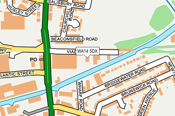
WA14 5DX is located in the Broadheath electoral ward, within the metropolitan district of Trafford and the English Parliamentary constituency of Altrincham and Sale West. The Sub Integrated Care Board (ICB) Location is NHS Greater Manchester ICB - 02A and the police force is Greater Manchester. This postcode has been in use since January 1980.


GetTheData
Source: OS OpenMap – Local (Ordnance Survey)
Source: OS VectorMap District (Ordnance Survey)
Licence: Open Government Licence (requires attribution)
| Easting | 376832 |
| Northing | 389199 |
| Latitude | 53.399120 |
| Longitude | -2.349899 |
GetTheData
Source: Open Postcode Geo
Licence: Open Government Licence
| Country | England |
| Postcode District | WA14 |
➜ See where WA14 is on a map ➜ Where is Altrincham? | |
GetTheData
Source: Land Registry Price Paid Data
Licence: Open Government Licence
Elevation or altitude of WA14 5DX as distance above sea level:
| Metres | Feet | |
|---|---|---|
| Elevation | 30m | 98ft |
Elevation is measured from the approximate centre of the postcode, to the nearest point on an OS contour line from OS Terrain 50, which has contour spacing of ten vertical metres.
➜ How high above sea level am I? Find the elevation of your current position using your device's GPS.
GetTheData
Source: Open Postcode Elevation
Licence: Open Government Licence
| Ward | Broadheath |
| Constituency | Altrincham And Sale West |
GetTheData
Source: ONS Postcode Database
Licence: Open Government Licence
| Manchester Road/George Richards Way (Manchester Road) | Broadheath | 179m |
| Manchester Road/Cheshire Cheese (Manchester Road) | Broadheath | 227m |
| Manchester Road/The Navigation (Manchester Road) | Broadheath | 280m |
| Sinderland Road/Manchester Road (Sinderland Road) | Broadheath | 296m |
| Manchester Road/Sinderland Road (Manchester Road) | Broadheath | 302m |
| Navigation Road (Manchester Metrolink) (Navigation Road) | Navigation Road | 612m |
| Timperley (Manchester Metrolink) (Park Road) | Timperley | 921m |
| Altrincham (Manchester Metrolink) (Stamford New Road) | Altrincham | 1,253m |
| Navigation Road Station | 0.6km |
| Altrincham Station | 1.3km |
| Hale Station | 2.3km |
GetTheData
Source: NaPTAN
Licence: Open Government Licence
GetTheData
Source: ONS Postcode Database
Licence: Open Government Licence


➜ Get more ratings from the Food Standards Agency
GetTheData
Source: Food Standards Agency
Licence: FSA terms & conditions
| Last Collection | |||
|---|---|---|---|
| Location | Mon-Fri | Sat | Distance |
| Navigation Road | 17:30 | 11:00 | 222m |
| Bemrose Avenue | 16:00 | 11:00 | 533m |
| Wellington Road | 16:00 | 11:00 | 652m |
GetTheData
Source: Dracos
Licence: Creative Commons Attribution-ShareAlike
The below table lists the International Territorial Level (ITL) codes (formerly Nomenclature of Territorial Units for Statistics (NUTS) codes) and Local Administrative Units (LAU) codes for WA14 5DX:
| ITL 1 Code | Name |
|---|---|
| TLD | North West (England) |
| ITL 2 Code | Name |
| TLD3 | Greater Manchester |
| ITL 3 Code | Name |
| TLD34 | Greater Manchester South West |
| LAU 1 Code | Name |
| E08000009 | Trafford |
GetTheData
Source: ONS Postcode Directory
Licence: Open Government Licence
The below table lists the Census Output Area (OA), Lower Layer Super Output Area (LSOA), and Middle Layer Super Output Area (MSOA) for WA14 5DX:
| Code | Name | |
|---|---|---|
| OA | E00030881 | |
| LSOA | E01006089 | Trafford 024C |
| MSOA | E02001282 | Trafford 024 |
GetTheData
Source: ONS Postcode Directory
Licence: Open Government Licence
| WA14 1NJ | Emery Close | 59m |
| WA14 1NE | Granford Close | 98m |
| WA14 5LQ | Beaconsfield Road | 107m |
| WA14 5PZ | Manchester Road | 116m |
| WA14 1LZ | Bridgewater Road | 133m |
| WA14 1LB | Bridgewater Road | 137m |
| WA14 1PB | Lampton Close | 149m |
| WA14 1ND | Wharf Road | 150m |
| WA14 1LP | Brunswick Road | 171m |
| WA14 1LW | Navigation Road | 180m |
GetTheData
Source: Open Postcode Geo; Land Registry Price Paid Data
Licence: Open Government Licence