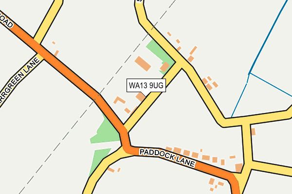
WA13 9UG lies on Barns Lane in Warburton, Lymm. WA13 9UG is located in the Bowdon electoral ward, within the metropolitan district of Trafford and the English Parliamentary constituency of Altrincham and Sale West. The Sub Integrated Care Board (ICB) Location is NHS Greater Manchester ICB - 02A and the police force is Greater Manchester. This postcode has been in use since January 1980.


GetTheData
Source: OS OpenMap – Local (Ordnance Survey)
Source: OS VectorMap District (Ordnance Survey)
Licence: Open Government Licence (requires attribution)
| Easting | 372465 |
| Northing | 388624 |
| Latitude | 53.393741 |
| Longitude | -2.415523 |
GetTheData
Source: Open Postcode Geo
Licence: Open Government Licence
| Street | Barns Lane |
| Locality | Warburton |
| Town/City | Lymm |
| Country | England |
| Postcode District | WA13 |
➜ See where WA13 is on a map ➜ Where is Dunham Woodhouses? | |
GetTheData
Source: Land Registry Price Paid Data
Licence: Open Government Licence
Elevation or altitude of WA13 9UG as distance above sea level:
| Metres | Feet | |
|---|---|---|
| Elevation | 20m | 66ft |
Elevation is measured from the approximate centre of the postcode, to the nearest point on an OS contour line from OS Terrain 50, which has contour spacing of ten vertical metres.
➜ How high above sea level am I? Find the elevation of your current position using your device's GPS.
GetTheData
Source: Open Postcode Elevation
Licence: Open Government Licence
| Ward | Bowdon |
| Constituency | Altrincham And Sale West |
GetTheData
Source: ONS Postcode Database
Licence: Open Government Licence
| Paddock Lane/Rope And Anchor (Paddock Lane) | Dunham Woodhouses | 198m |
| Paddock Lane/Rope And Anchor (Dunham Road) | Dunham Woodhouses | 199m |
| Dunham Road/Gorsey Lane (Dunham Road) | Carr Green | 260m |
| Dunham Road/Gorsey Lane (Dunham Road) | Carr Green | 268m |
| Station Road/Vine Inn (Station Road) | Dunham Woodhouses | 628m |
| Altrincham Station | 4.6km |
| Irlam Station | 4.7km |
| Navigation Road Station | 4.8km |
GetTheData
Source: NaPTAN
Licence: Open Government Licence
| Percentage of properties with Next Generation Access | 100.0% |
| Percentage of properties with Superfast Broadband | 0.0% |
| Percentage of properties with Ultrafast Broadband | 0.0% |
| Percentage of properties with Full Fibre Broadband | 0.0% |
Superfast Broadband is between 30Mbps and 300Mbps
Ultrafast Broadband is > 300Mbps
| Percentage of properties unable to receive 2Mbps | 0.0% |
| Percentage of properties unable to receive 5Mbps | 100.0% |
| Percentage of properties unable to receive 10Mbps | 100.0% |
| Percentage of properties unable to receive 30Mbps | 100.0% |
GetTheData
Source: Ofcom
Licence: Ofcom Terms of Use (requires attribution)
GetTheData
Source: ONS Postcode Database
Licence: Open Government Licence


➜ Get more ratings from the Food Standards Agency
GetTheData
Source: Food Standards Agency
Licence: FSA terms & conditions
| Last Collection | |||
|---|---|---|---|
| Location | Mon-Fri | Sat | Distance |
| Warburton Cross | 17:30 | 11:00 | 1,658m |
| Birch Brook Road | 17:30 | 11:00 | 2,234m |
| 22 Cross Lane West | 17:30 | 11:30 | 2,464m |
GetTheData
Source: Dracos
Licence: Creative Commons Attribution-ShareAlike
The below table lists the International Territorial Level (ITL) codes (formerly Nomenclature of Territorial Units for Statistics (NUTS) codes) and Local Administrative Units (LAU) codes for WA13 9UG:
| ITL 1 Code | Name |
|---|---|
| TLD | North West (England) |
| ITL 2 Code | Name |
| TLD3 | Greater Manchester |
| ITL 3 Code | Name |
| TLD34 | Greater Manchester South West |
| LAU 1 Code | Name |
| E08000009 | Trafford |
GetTheData
Source: ONS Postcode Directory
Licence: Open Government Licence
The below table lists the Census Output Area (OA), Lower Layer Super Output Area (LSOA), and Middle Layer Super Output Area (MSOA) for WA13 9UG:
| Code | Name | |
|---|---|---|
| OA | E00030848 | |
| LSOA | E01006087 | Trafford 025E |
| MSOA | E02001283 | Trafford 025 |
GetTheData
Source: ONS Postcode Directory
Licence: Open Government Licence
| WA14 5SJ | Sawpit Street | 104m |
| WA14 5RP | Paddock Lane | 183m |
| WA14 5RR | Barns Lane | 201m |
| WA13 9UQ | Dunham Road | 214m |
| WA13 9UH | Dunham Road | 523m |
| WA14 5SG | Station Road | 565m |
| WA13 9UA | Gorsey Lane | 641m |
| WA14 5SA | Station Road | 665m |
| WA14 5SB | Woodhouse Lane | 738m |
| WA13 9UL | Carr Green Lane | 752m |
GetTheData
Source: Open Postcode Geo; Land Registry Price Paid Data
Licence: Open Government Licence