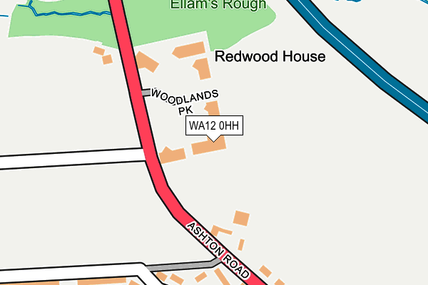
WA12 0HH is located in the Newton-le-Willows East electoral ward, within the metropolitan district of St. Helens and the English Parliamentary constituency of St Helens North. The Sub Integrated Care Board (ICB) Location is NHS Cheshire and Merseyside ICB - 01X and the police force is Merseyside. This postcode has been in use since June 1999.


GetTheData
Source: OS OpenMap – Local (Ordnance Survey)
Source: OS VectorMap District (Ordnance Survey)
Licence: Open Government Licence (requires attribution)
| Easting | 358184 |
| Northing | 396703 |
| Latitude | 53.465398 |
| Longitude | -2.631340 |
GetTheData
Source: Open Postcode Geo
Licence: Open Government Licence
| Country | England |
| Postcode District | WA12 |
➜ See where WA12 is on a map | |
GetTheData
Source: Land Registry Price Paid Data
Licence: Open Government Licence
Elevation or altitude of WA12 0HH as distance above sea level:
| Metres | Feet | |
|---|---|---|
| Elevation | 40m | 131ft |
Elevation is measured from the approximate centre of the postcode, to the nearest point on an OS contour line from OS Terrain 50, which has contour spacing of ten vertical metres.
➜ How high above sea level am I? Find the elevation of your current position using your device's GPS.
GetTheData
Source: Open Postcode Elevation
Licence: Open Government Licence
| Ward | Newton-le-willows East |
| Constituency | St Helens North |
GetTheData
Source: ONS Postcode Database
Licence: Open Government Licence
| Woodlands Business Park (Ashton Road) | Newton Le Willows | 106m |
| Woodlands Business Park (Ashton Road) | Newton Le Willows | 117m |
| Johnson Avenue (Queens Drive) | Crow Lane | 364m |
| Billington Avenue (Queens Drive) | Crow Lane | 379m |
| Johnson Avenue (Queens Drive) | Crow Lane | 395m |
| Earlestown Station | 1.6km |
| Newton-le-Willows Station | 1.8km |
| Garswood Station | 3.7km |
GetTheData
Source: NaPTAN
Licence: Open Government Licence
GetTheData
Source: ONS Postcode Database
Licence: Open Government Licence


➜ Get more ratings from the Food Standards Agency
GetTheData
Source: Food Standards Agency
Licence: FSA terms & conditions
| Last Collection | |||
|---|---|---|---|
| Location | Mon-Fri | Sat | Distance |
| 78 Ashton Road | 17:30 | 11:00 | 472m |
| Elston Avenue | 16:30 | 11:00 | 519m |
| 12 Davies Avenue | 16:15 | 11:00 | 708m |
GetTheData
Source: Dracos
Licence: Creative Commons Attribution-ShareAlike
The below table lists the International Territorial Level (ITL) codes (formerly Nomenclature of Territorial Units for Statistics (NUTS) codes) and Local Administrative Units (LAU) codes for WA12 0HH:
| ITL 1 Code | Name |
|---|---|
| TLD | North West (England) |
| ITL 2 Code | Name |
| TLD7 | Merseyside |
| ITL 3 Code | Name |
| TLD71 | East Merseyside |
| LAU 1 Code | Name |
| E08000013 | St. Helens |
GetTheData
Source: ONS Postcode Directory
Licence: Open Government Licence
The below table lists the Census Output Area (OA), Lower Layer Super Output Area (LSOA), and Middle Layer Super Output Area (MSOA) for WA12 0HH:
| Code | Name | |
|---|---|---|
| OA | E00034778 | |
| LSOA | E01006856 | St. Helens 015A |
| MSOA | E02001420 | St. Helens 015 |
GetTheData
Source: ONS Postcode Directory
Licence: Open Government Licence
| WA12 0AN | Ashton Road | 194m |
| WA12 0HP | Ashton Road | 212m |
| WA12 0AW | Billington Avenue | 230m |
| WA12 0AU | Billington Avenue | 267m |
| WA12 0LN | Queens Drive | 298m |
| WA12 0AH | Ashton Road | 346m |
| WA12 0AJ | Ashton Road | 346m |
| WA12 0LJ | Queens Drive | 347m |
| WA12 0NF | Dixon Avenue | 361m |
| WA12 0HN | Ashton Road | 378m |
GetTheData
Source: Open Postcode Geo; Land Registry Price Paid Data
Licence: Open Government Licence