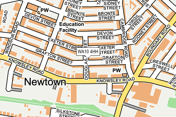
WA10 4HH lies on Douglas Street in St. Helens. WA10 4HH is located in the West Park electoral ward, within the metropolitan district of St. Helens and the English Parliamentary constituency of St Helens South and Whiston. The Sub Integrated Care Board (ICB) Location is NHS Cheshire and Merseyside ICB - 01X and the police force is Merseyside. This postcode has been in use since January 1980.


GetTheData
Source: OS OpenMap – Local (Ordnance Survey)
Source: OS VectorMap District (Ordnance Survey)
Licence: Open Government Licence (requires attribution)
| Easting | 349974 |
| Northing | 395409 |
| Latitude | 53.453050 |
| Longitude | -2.754789 |
GetTheData
Source: Open Postcode Geo
Licence: Open Government Licence
| Street | Douglas Street |
| Town/City | St. Helens |
| Country | England |
| Postcode District | WA10 |
➜ See where WA10 is on a map ➜ Where is St Helens? | |
GetTheData
Source: Land Registry Price Paid Data
Licence: Open Government Licence
Elevation or altitude of WA10 4HH as distance above sea level:
| Metres | Feet | |
|---|---|---|
| Elevation | 40m | 131ft |
Elevation is measured from the approximate centre of the postcode, to the nearest point on an OS contour line from OS Terrain 50, which has contour spacing of ten vertical metres.
➜ How high above sea level am I? Find the elevation of your current position using your device's GPS.
GetTheData
Source: Open Postcode Elevation
Licence: Open Government Licence
| Ward | West Park |
| Constituency | St Helens South And Whiston |
GetTheData
Source: ONS Postcode Database
Licence: Open Government Licence
| Elliot Street (Knowsley Road) | St Helens Newtown | 93m |
| Cambridge Road (Knowsley Road) | St Helens Newtown | 108m |
| Grafton Street (Rivington Road) | St Helens Newtown | 144m |
| Grafton Street (Rivington Road) | St Helens Newtown | 158m |
| Rivington Road (Knowsley Road) | St Helens Newtown | 165m |
| St Helens Central Station | 1.6km |
| Thatto Heath Station | 1.9km |
| Eccleston Park Station | 3km |
GetTheData
Source: NaPTAN
Licence: Open Government Licence
| Percentage of properties with Next Generation Access | 100.0% |
| Percentage of properties with Superfast Broadband | 100.0% |
| Percentage of properties with Ultrafast Broadband | 100.0% |
| Percentage of properties with Full Fibre Broadband | 0.0% |
Superfast Broadband is between 30Mbps and 300Mbps
Ultrafast Broadband is > 300Mbps
| Percentage of properties unable to receive 2Mbps | 0.0% |
| Percentage of properties unable to receive 5Mbps | 0.0% |
| Percentage of properties unable to receive 10Mbps | 0.0% |
| Percentage of properties unable to receive 30Mbps | 0.0% |
GetTheData
Source: Ofcom
Licence: Ofcom Terms of Use (requires attribution)
GetTheData
Source: ONS Postcode Database
Licence: Open Government Licence


➜ Get more ratings from the Food Standards Agency
GetTheData
Source: Food Standards Agency
Licence: FSA terms & conditions
| Last Collection | |||
|---|---|---|---|
| Location | Mon-Fri | Sat | Distance |
| Eccleston Hill | 16:00 | 11:00 | 437m |
| Boundary Road | 17:30 | 11:00 | 871m |
| Liverpool Road Business Box | 18:30 | 880m | |
GetTheData
Source: Dracos
Licence: Creative Commons Attribution-ShareAlike
The below table lists the International Territorial Level (ITL) codes (formerly Nomenclature of Territorial Units for Statistics (NUTS) codes) and Local Administrative Units (LAU) codes for WA10 4HH:
| ITL 1 Code | Name |
|---|---|
| TLD | North West (England) |
| ITL 2 Code | Name |
| TLD7 | Merseyside |
| ITL 3 Code | Name |
| TLD71 | East Merseyside |
| LAU 1 Code | Name |
| E08000013 | St. Helens |
GetTheData
Source: ONS Postcode Directory
Licence: Open Government Licence
The below table lists the Census Output Area (OA), Lower Layer Super Output Area (LSOA), and Middle Layer Super Output Area (MSOA) for WA10 4HH:
| Code | Name | |
|---|---|---|
| OA | E00034878 | |
| LSOA | E01006880 | St. Helens 012D |
| MSOA | E02001417 | St. Helens 012 |
GetTheData
Source: ONS Postcode Directory
Licence: Open Government Licence
| WA10 4HQ | Grafton Street | 55m |
| WA10 4PW | Knowsley Road | 59m |
| WA10 4HJ | Grafton Street | 66m |
| WA10 4HS | Exeter Street | 68m |
| WA10 4HR | Exeter Street | 71m |
| WA10 4HU | Devon Street | 75m |
| WA10 4HT | Devon Street | 98m |
| WA10 4HY | Rivington Road | 119m |
| WA10 4PJ | Knowsley Road | 125m |
| WA10 4JD | Bronte Street | 127m |
GetTheData
Source: Open Postcode Geo; Land Registry Price Paid Data
Licence: Open Government Licence