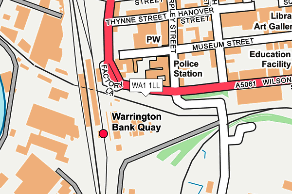
WA1 1LL is located in the Bewsey and Whitecross electoral ward, within the unitary authority of Warrington and the English Parliamentary constituency of Warrington South. The Sub Integrated Care Board (ICB) Location is NHS Cheshire and Merseyside ICB - 02E and the police force is Cheshire. This postcode has been in use since February 1990.


GetTheData
Source: OS OpenMap – Local (Ordnance Survey)
Source: OS VectorMap District (Ordnance Survey)
Licence: Open Government Licence (requires attribution)
| Easting | 360102 |
| Northing | 387815 |
| Latitude | 53.385661 |
| Longitude | -2.601322 |
GetTheData
Source: Open Postcode Geo
Licence: Open Government Licence
| Country | England |
| Postcode District | WA1 |
➜ See where WA1 is on a map ➜ Where is Warrington? | |
GetTheData
Source: Land Registry Price Paid Data
Licence: Open Government Licence
Elevation or altitude of WA1 1LL as distance above sea level:
| Metres | Feet | |
|---|---|---|
| Elevation | 10m | 33ft |
Elevation is measured from the approximate centre of the postcode, to the nearest point on an OS contour line from OS Terrain 50, which has contour spacing of ten vertical metres.
➜ How high above sea level am I? Find the elevation of your current position using your device's GPS.
GetTheData
Source: Open Postcode Elevation
Licence: Open Government Licence
| Ward | Bewsey And Whitecross |
| Constituency | Warrington South |
GetTheData
Source: ONS Postcode Database
Licence: Open Government Licence
| Arpley Street (Wilson Patten Street) | Bank Quay | 27m |
| Warrington Bank Quay Station (Parker Street) | Bank Quay | 92m |
| Railway Bridge (Slutchers Lane) | Bank Quay | 163m |
| Thynne Street (Parker Street) | Bank Quay | 185m |
| Centre Park (Slutchers Lane) | Centre Park | 239m |
| Warrington Bank Quay Station | 0.1km |
| Warrington Central Station | 0.9km |
| Sankey for Penketh Station | 3.4km |
GetTheData
Source: NaPTAN
Licence: Open Government Licence
GetTheData
Source: ONS Postcode Database
Licence: Open Government Licence


➜ Get more ratings from the Food Standards Agency
GetTheData
Source: Food Standards Agency
Licence: FSA terms & conditions
| Last Collection | |||
|---|---|---|---|
| Location | Mon-Fri | Sat | Distance |
| Bank Quay Station | 17:30 | 11:00 | 94m |
| Springfield Street | 18:00 | 11:00 | 331m |
| Springfield St | 18:30 | 331m | |
GetTheData
Source: Dracos
Licence: Creative Commons Attribution-ShareAlike
The below table lists the International Territorial Level (ITL) codes (formerly Nomenclature of Territorial Units for Statistics (NUTS) codes) and Local Administrative Units (LAU) codes for WA1 1LL:
| ITL 1 Code | Name |
|---|---|
| TLD | North West (England) |
| ITL 2 Code | Name |
| TLD6 | Cheshire |
| ITL 3 Code | Name |
| TLD61 | Warrington |
| LAU 1 Code | Name |
| E06000007 | Warrington |
GetTheData
Source: ONS Postcode Directory
Licence: Open Government Licence
The below table lists the Census Output Area (OA), Lower Layer Super Output Area (LSOA), and Middle Layer Super Output Area (MSOA) for WA1 1LL:
| Code | Name | |
|---|---|---|
| OA | E00062808 | |
| LSOA | E01033302 | Warrington 018G |
| MSOA | E02002607 | Warrington 018 |
GetTheData
Source: ONS Postcode Directory
Licence: Open Government Licence
| WA1 1NF | Wilson Patten Street | 79m |
| WA1 1LF | Arpley Street | 94m |
| WA1 1LD | Museum Street | 128m |
| WA1 1LX | Arpley Street | 144m |
| WA1 1PE | Thynne Street | 173m |
| WA1 1JY | Winmarleigh Street | 173m |
| WA1 1LZ | Hanover Street | 191m |
| WA1 1NR | White Street | 203m |
| WA1 1NZ | Arpley Street | 210m |
| WA1 1LT | Parker Street | 227m |
GetTheData
Source: Open Postcode Geo; Land Registry Price Paid Data
Licence: Open Government Licence