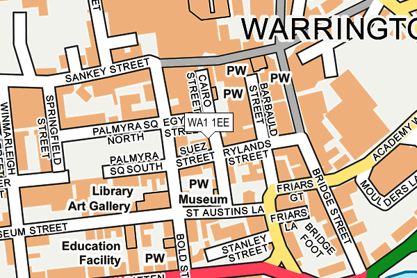
WA1 1EE lies on Cairo Street in Warrington. WA1 1EE is located in the Bewsey and Whitecross electoral ward, within the unitary authority of Warrington and the English Parliamentary constituency of Warrington South. The Sub Integrated Care Board (ICB) Location is NHS Cheshire and Merseyside ICB - 02E and the police force is Cheshire. This postcode has been in use since January 1980.


GetTheData
Source: OS OpenMap – Local (Ordnance Survey)
Source: OS VectorMap District (Ordnance Survey)
Licence: Open Government Licence (requires attribution)
| Easting | 360511 |
| Northing | 388106 |
| Latitude | 53.388324 |
| Longitude | -2.595209 |
GetTheData
Source: Open Postcode Geo
Licence: Open Government Licence
| Street | Cairo Street |
| Town/City | Warrington |
| Country | England |
| Postcode District | WA1 |
➜ See where WA1 is on a map ➜ Where is Warrington? | |
GetTheData
Source: Land Registry Price Paid Data
Licence: Open Government Licence
Elevation or altitude of WA1 1EE as distance above sea level:
| Metres | Feet | |
|---|---|---|
| Elevation | 10m | 33ft |
Elevation is measured from the approximate centre of the postcode, to the nearest point on an OS contour line from OS Terrain 50, which has contour spacing of ten vertical metres.
➜ How high above sea level am I? Find the elevation of your current position using your device's GPS.
GetTheData
Source: Open Postcode Elevation
Licence: Open Government Licence
| Ward | Bewsey And Whitecross |
| Constituency | Warrington South |
GetTheData
Source: ONS Postcode Database
Licence: Open Government Licence
| Rylands Street | Warrington | 84m |
| White Hart (Sankey Street) | Warrington | 114m |
| Rylands Street (Bridge Street) | Warrington | 124m |
| White Hart (Sankey Street) | Warrington | 126m |
| Garven Place Alighting Only (Sankey Street) | Warrington | 166m |
| Warrington Central Station | 0.4km |
| Warrington Bank Quay Station | 0.5km |
| Padgate Station | 3.2km |
GetTheData
Source: NaPTAN
Licence: Open Government Licence
GetTheData
Source: ONS Postcode Database
Licence: Open Government Licence


➜ Get more ratings from the Food Standards Agency
GetTheData
Source: Food Standards Agency
Licence: FSA terms & conditions
| Last Collection | |||
|---|---|---|---|
| Location | Mon-Fri | Sat | Distance |
| White Hart | 17:30 | 11:00 | 101m |
| Bold Street | 17:30 | 11:00 | 156m |
| Golden Square | 17:30 | 11:00 | 162m |
GetTheData
Source: Dracos
Licence: Creative Commons Attribution-ShareAlike
The below table lists the International Territorial Level (ITL) codes (formerly Nomenclature of Territorial Units for Statistics (NUTS) codes) and Local Administrative Units (LAU) codes for WA1 1EE:
| ITL 1 Code | Name |
|---|---|
| TLD | North West (England) |
| ITL 2 Code | Name |
| TLD6 | Cheshire |
| ITL 3 Code | Name |
| TLD61 | Warrington |
| LAU 1 Code | Name |
| E06000007 | Warrington |
GetTheData
Source: ONS Postcode Directory
Licence: Open Government Licence
The below table lists the Census Output Area (OA), Lower Layer Super Output Area (LSOA), and Middle Layer Super Output Area (MSOA) for WA1 1EE:
| Code | Name | |
|---|---|---|
| OA | E00173146 | |
| LSOA | E01033300 | Warrington 018F |
| MSOA | E02002607 | Warrington 018 |
GetTheData
Source: ONS Postcode Directory
Licence: Open Government Licence
| WA1 1DY | Egypt Street | 29m |
| WA1 1XG | Sankey Street | 59m |
| WA1 1ED | Cairo Street | 59m |
| WA1 1EF | Suez Street | 62m |
| WA1 1DH | Bold Street | 67m |
| WA1 1DR | Bold Street | 72m |
| WA1 1DG | Bold Street | 72m |
| WA1 1EG | Suez Street | 86m |
| WA1 1EN | Rylands Street | 98m |
| WA1 1EH | Cairo Street | 103m |
GetTheData
Source: Open Postcode Geo; Land Registry Price Paid Data
Licence: Open Government Licence