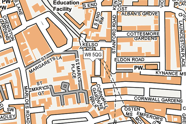
W8 5QG lies on Kelso Place in London. W8 5QG is located in the Queen's Gate electoral ward, within the London borough of Kensington and Chelsea and the English Parliamentary constituency of Kensington. The Sub Integrated Care Board (ICB) Location is NHS North West London ICB - W2U3Z and the police force is Metropolitan Police. This postcode has been in use since January 1980.


GetTheData
Source: OS OpenMap – Local (Ordnance Survey)
Source: OS VectorMap District (Ordnance Survey)
Licence: Open Government Licence (requires attribution)
| Easting | 525794 |
| Northing | 179204 |
| Latitude | 51.497788 |
| Longitude | -0.189204 |
GetTheData
Source: Open Postcode Geo
Licence: Open Government Licence
| Street | Kelso Place |
| Town/City | London |
| Country | England |
| Postcode District | W8 |
➜ See where W8 is on a map ➜ Where is Kensington? | |
GetTheData
Source: Land Registry Price Paid Data
Licence: Open Government Licence
Elevation or altitude of W8 5QG as distance above sea level:
| Metres | Feet | |
|---|---|---|
| Elevation | 10m | 33ft |
Elevation is measured from the approximate centre of the postcode, to the nearest point on an OS contour line from OS Terrain 50, which has contour spacing of ten vertical metres.
➜ How high above sea level am I? Find the elevation of your current position using your device's GPS.
GetTheData
Source: Open Postcode Elevation
Licence: Open Government Licence
| Ward | Queen's Gate |
| Constituency | Kensington |
GetTheData
Source: ONS Postcode Database
Licence: Open Government Licence
| Cromwell Hospital (Cromwell Road) | Earls Court | 359m |
| Collingham Road Sainsbury's (Cromwell Road) | South Kensington | 359m |
| Queens Gate Terrace (Gloucester Road) | South Kensington | 380m |
| Queens Gate Terrace (Gloucester Road) | South Kensington | 381m |
| Cornwall Gardens | South Kensington | 430m |
| High Street Kensington Underground Station | High Street Kensington | 440m |
| Gloucester Road Underground Station | Gloucester Road | 597m |
| Earl's Court Underground Station | Earls Court | 700m |
| South Kensington Underground Station | South Kensington | 1,124m |
| West Brompton Underground Station | West Brompton | 1,252m |
| West Brompton Station | 1.3km |
| Kensington (Olympia) Station | 1.5km |
| Shepherds Bush Station | 2.1km |
GetTheData
Source: NaPTAN
Licence: Open Government Licence
| Percentage of properties with Next Generation Access | 100.0% |
| Percentage of properties with Superfast Broadband | 100.0% |
| Percentage of properties with Ultrafast Broadband | 100.0% |
| Percentage of properties with Full Fibre Broadband | 0.0% |
Superfast Broadband is between 30Mbps and 300Mbps
Ultrafast Broadband is > 300Mbps
| Median download speed | 67.5Mbps |
| Average download speed | 80.3Mbps |
| Maximum download speed | 200.00Mbps |
| Median upload speed | 5.6Mbps |
| Average upload speed | 7.0Mbps |
| Maximum upload speed | 20.00Mbps |
| Percentage of properties unable to receive 2Mbps | 0.0% |
| Percentage of properties unable to receive 5Mbps | 0.0% |
| Percentage of properties unable to receive 10Mbps | 0.0% |
| Percentage of properties unable to receive 30Mbps | 0.0% |
GetTheData
Source: Ofcom
Licence: Ofcom Terms of Use (requires attribution)
Estimated total energy consumption in W8 5QG by fuel type, 2015.
| Consumption (kWh) | 333,907 |
|---|---|
| Meter count | 15 |
| Mean (kWh/meter) | 22,260 |
| Median (kWh/meter) | 21,591 |
| Consumption (kWh) | 80,973 |
|---|---|
| Meter count | 15 |
| Mean (kWh/meter) | 5,398 |
| Median (kWh/meter) | 4,390 |
GetTheData
Source: Postcode level gas estimates: 2015 (experimental)
Source: Postcode level electricity estimates: 2015 (experimental)
Licence: Open Government Licence
GetTheData
Source: ONS Postcode Database
Licence: Open Government Licence


➜ Get more ratings from the Food Standards Agency
GetTheData
Source: Food Standards Agency
Licence: FSA terms & conditions
| Last Collection | |||
|---|---|---|---|
| Location | Mon-Fri | Sat | Distance |
| Stanford Road | 17:30 | 12:00 | 110m |
| Cornwall Gardens | 17:30 | 12:00 | 113m |
| Lexham Gardens | 17:30 | 12:00 | 207m |
GetTheData
Source: Dracos
Licence: Creative Commons Attribution-ShareAlike
The below table lists the International Territorial Level (ITL) codes (formerly Nomenclature of Territorial Units for Statistics (NUTS) codes) and Local Administrative Units (LAU) codes for W8 5QG:
| ITL 1 Code | Name |
|---|---|
| TLI | London |
| ITL 2 Code | Name |
| TLI3 | Inner London - West |
| ITL 3 Code | Name |
| TLI33 | Kensington & Chelsea and Hammersmith & Fulham |
| LAU 1 Code | Name |
| E09000020 | Kensington and Chelsea |
GetTheData
Source: ONS Postcode Directory
Licence: Open Government Licence
The below table lists the Census Output Area (OA), Lower Layer Super Output Area (LSOA), and Middle Layer Super Output Area (MSOA) for W8 5QG:
| Code | Name | |
|---|---|---|
| OA | E00014539 | |
| LSOA | E01002890 | Kensington and Chelsea 010C |
| MSOA | E02000586 | Kensington and Chelsea 010 |
GetTheData
Source: ONS Postcode Directory
Licence: Open Government Licence
| W8 5QD | Kelso Place | 28m |
| SW7 4BH | Cornwall Mews West | 45m |
| W8 5PZ | Stanford Road | 45m |
| W8 5UE | St Marys Place | 50m |
| W8 5QR | Kelso Place | 50m |
| SW7 4AD | Cornwall Gardens | 71m |
| W8 5QP | Kelso Place | 75m |
| W8 5QW | Stanford Road | 76m |
| W8 5QQ | Kelso Place | 83m |
| W8 5UJ | Chantry Square | 85m |
GetTheData
Source: Open Postcode Geo; Land Registry Price Paid Data
Licence: Open Government Licence