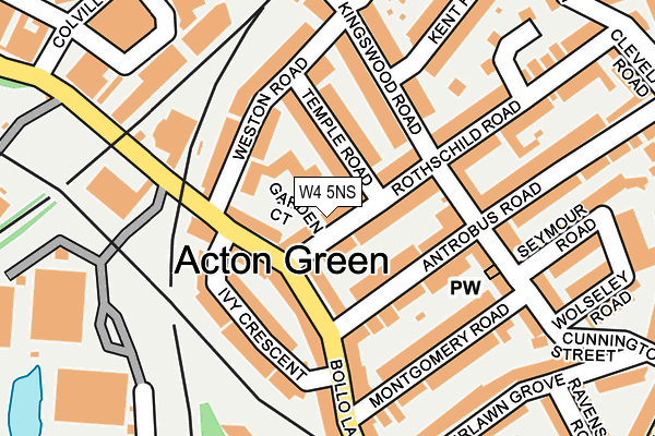
W4 5NS lies on Rothschild Road in London. W4 5NS is located in the Southfield electoral ward, within the London borough of Ealing and the English Parliamentary constituency of Ealing Central and Acton. The Sub Integrated Care Board (ICB) Location is NHS North West London ICB - W2U3Z and the police force is Metropolitan Police. This postcode has been in use since January 1980.


GetTheData
Source: OS OpenMap – Local (Ordnance Survey)
Source: OS VectorMap District (Ordnance Survey)
Licence: Open Government Licence (requires attribution)
| Easting | 520163 |
| Northing | 178997 |
| Latitude | 51.497152 |
| Longitude | -0.270354 |
GetTheData
Source: Open Postcode Geo
Licence: Open Government Licence
| Street | Rothschild Road |
| Town/City | London |
| Country | England |
| Postcode District | W4 |
➜ See where W4 is on a map ➜ Where is Acton? | |
GetTheData
Source: Land Registry Price Paid Data
Licence: Open Government Licence
Elevation or altitude of W4 5NS as distance above sea level:
| Metres | Feet | |
|---|---|---|
| Elevation | 10m | 33ft |
Elevation is measured from the approximate centre of the postcode, to the nearest point on an OS contour line from OS Terrain 50, which has contour spacing of ten vertical metres.
➜ How high above sea level am I? Find the elevation of your current position using your device's GPS.
GetTheData
Source: Open Postcode Elevation
Licence: Open Government Licence
| Ward | Southfield |
| Constituency | Ealing Central And Acton |
GetTheData
Source: ONS Postcode Database
Licence: Open Government Licence
| South Acton Station | South Acton | 102m |
| South Acton Station | South Acton | 105m |
| Montgomery Road Chiswick (Bollo Lane) | Chiswick Park | 170m |
| Montgomery Road Chiswick (Bollo Lane) | Chiswick Park | 204m |
| Chiswick Business Park | Chiswick Park | 213m |
| Chiswick Park Underground Station | Chiswick Park | 326m |
| Gunnersbury Underground Station | Gunnersbury | 686m |
| Acton Town Underground Station | Acton Town | 961m |
| Turnham Green Underground Station | Turnham Green | 1,119m |
| Ealing Common Underground Station | Ealing Common | 1,906m |
| South Acton Station | 0.3km |
| Gunnersbury Station | 0.7km |
| Acton Central Station | 1.4km |
GetTheData
Source: NaPTAN
Licence: Open Government Licence
| Percentage of properties with Next Generation Access | 100.0% |
| Percentage of properties with Superfast Broadband | 100.0% |
| Percentage of properties with Ultrafast Broadband | 89.5% |
| Percentage of properties with Full Fibre Broadband | 0.0% |
Superfast Broadband is between 30Mbps and 300Mbps
Ultrafast Broadband is > 300Mbps
| Median download speed | 90.0Mbps |
| Average download speed | 95.4Mbps |
| Maximum download speed | 200.00Mbps |
| Median upload speed | 13.4Mbps |
| Average upload speed | 12.2Mbps |
| Maximum upload speed | 20.00Mbps |
| Percentage of properties unable to receive 2Mbps | 0.0% |
| Percentage of properties unable to receive 5Mbps | 0.0% |
| Percentage of properties unable to receive 10Mbps | 0.0% |
| Percentage of properties unable to receive 30Mbps | 0.0% |
GetTheData
Source: Ofcom
Licence: Ofcom Terms of Use (requires attribution)
Estimated total energy consumption in W4 5NS by fuel type, 2015.
| Consumption (kWh) | 242,455 |
|---|---|
| Meter count | 20 |
| Mean (kWh/meter) | 12,123 |
| Median (kWh/meter) | 9,129 |
| Consumption (kWh) | 67,617 |
|---|---|
| Meter count | 21 |
| Mean (kWh/meter) | 3,220 |
| Median (kWh/meter) | 2,696 |
GetTheData
Source: Postcode level gas estimates: 2015 (experimental)
Source: Postcode level electricity estimates: 2015 (experimental)
Licence: Open Government Licence
GetTheData
Source: ONS Postcode Database
Licence: Open Government Licence


➜ Get more ratings from the Food Standards Agency
GetTheData
Source: Food Standards Agency
Licence: FSA terms & conditions
| Last Collection | |||
|---|---|---|---|
| Location | Mon-Fri | Sat | Distance |
| Antrobus Road | 17:30 | 12:00 | 101m |
| Kingswood Road | 17:30 | 12:00 | 135m |
| Acton Lane | 17:30 | 12:00 | 371m |
GetTheData
Source: Dracos
Licence: Creative Commons Attribution-ShareAlike
The below table lists the International Territorial Level (ITL) codes (formerly Nomenclature of Territorial Units for Statistics (NUTS) codes) and Local Administrative Units (LAU) codes for W4 5NS:
| ITL 1 Code | Name |
|---|---|
| TLI | London |
| ITL 2 Code | Name |
| TLI7 | Outer London - West and North West |
| ITL 3 Code | Name |
| TLI73 | Ealing |
| LAU 1 Code | Name |
| E09000009 | Ealing |
GetTheData
Source: ONS Postcode Directory
Licence: Open Government Licence
The below table lists the Census Output Area (OA), Lower Layer Super Output Area (LSOA), and Middle Layer Super Output Area (MSOA) for W4 5NS:
| Code | Name | |
|---|---|---|
| OA | E00006821 | |
| LSOA | E01001380 | Ealing 040C |
| MSOA | E02006791 | Ealing 040 |
GetTheData
Source: ONS Postcode Directory
Licence: Open Government Licence
| W4 5NT | Rothschild Road | 43m |
| W4 5LS | Bollo Lane | 66m |
| W4 5LU | Bollo Lane | 73m |
| W4 5NW | Temple Road | 75m |
| W4 5NR | Rothschild Road | 77m |
| W4 5NQ | Antrobus Road | 79m |
| W4 5LT | Bollo Lane | 81m |
| W4 5NL | Weston Road | 100m |
| W4 5NJ | Weston Road | 113m |
| W4 5EP | Cunnington Street | 114m |
GetTheData
Source: Open Postcode Geo; Land Registry Price Paid Data
Licence: Open Government Licence