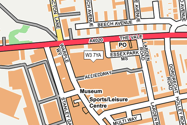
W3 7YA is located in the Southfield electoral ward, within the London borough of Ealing and the English Parliamentary constituency of Ealing Central and Acton. The Sub Integrated Care Board (ICB) Location is NHS North West London ICB - W2U3Z and the police force is Metropolitan Police. This postcode has been in use since January 1980.


GetTheData
Source: OS OpenMap – Local (Ordnance Survey)
Source: OS VectorMap District (Ordnance Survey)
Licence: Open Government Licence (requires attribution)
| Easting | 521180 |
| Northing | 180002 |
| Latitude | 51.505967 |
| Longitude | -0.255366 |
GetTheData
Source: Open Postcode Geo
Licence: Open Government Licence
| Country | England |
| Postcode District | W3 |
➜ See where W3 is on a map ➜ Where is Acton? | |
GetTheData
Source: Land Registry Price Paid Data
Licence: Open Government Licence
Elevation or altitude of W3 7YA as distance above sea level:
| Metres | Feet | |
|---|---|---|
| Elevation | 10m | 33ft |
Elevation is measured from the approximate centre of the postcode, to the nearest point on an OS contour line from OS Terrain 50, which has contour spacing of ten vertical metres.
➜ How high above sea level am I? Find the elevation of your current position using your device's GPS.
GetTheData
Source: Open Postcode Elevation
Licence: Open Government Licence
| Ward | Southfield |
| Constituency | Ealing Central And Acton |
GetTheData
Source: ONS Postcode Database
Licence: Open Government Licence
| East Acton Lane (The Vale) | East Acton | 80m |
| Larden Road (The Vale) | East Acton | 104m |
| Larden Road (The Vale) | East Acton | 116m |
| Acton Park Greenview Close (East Acton Lane) | East Acton | 157m |
| Acton Park Greenview Close (East Acton Lane) | East Acton | 180m |
| Turnham Green Underground Station | Turnham Green | 1,205m |
| East Acton Underground Station | East Acton | 1,311m |
| Stamford Brook Underground Station | Stamford Brook | 1,400m |
| Chiswick Park Underground Station | Chiswick Park | 1,535m |
| Ravenscourt Park Underground Station | Ravenscourt Park | 1,889m |
| Acton Central Station | 0.6km |
| South Acton Station | 1.2km |
| Acton Main Line Station | 1.5km |
GetTheData
Source: NaPTAN
Licence: Open Government Licence
GetTheData
Source: ONS Postcode Database
Licence: Open Government Licence


➜ Get more ratings from the Food Standards Agency
GetTheData
Source: Food Standards Agency
Licence: FSA terms & conditions
| Last Collection | |||
|---|---|---|---|
| Location | Mon-Fri | Sat | Distance |
| Post Office | 17:30 | 12:00 | 137m |
| Stanley Gardens | 17:30 | 12:00 | 152m |
| Bromyard Avenue | 17:30 | 12:00 | 335m |
GetTheData
Source: Dracos
Licence: Creative Commons Attribution-ShareAlike
The below table lists the International Territorial Level (ITL) codes (formerly Nomenclature of Territorial Units for Statistics (NUTS) codes) and Local Administrative Units (LAU) codes for W3 7YA:
| ITL 1 Code | Name |
|---|---|
| TLI | London |
| ITL 2 Code | Name |
| TLI7 | Outer London - West and North West |
| ITL 3 Code | Name |
| TLI73 | Ealing |
| LAU 1 Code | Name |
| E09000009 | Ealing |
GetTheData
Source: ONS Postcode Directory
Licence: Open Government Licence
The below table lists the Census Output Area (OA), Lower Layer Super Output Area (LSOA), and Middle Layer Super Output Area (MSOA) for W3 7YA:
| Code | Name | |
|---|---|---|
| OA | E00006861 | |
| LSOA | E01001381 | Ealing 034D |
| MSOA | E02000271 | Ealing 034 |
GetTheData
Source: ONS Postcode Directory
Licence: Open Government Licence
| W3 7RH | The Vale | 53m |
| W3 0RQ | Allied Way | 57m |
| W3 7RD | The Vale | 84m |
| W3 0BD | Warple Way | 86m |
| W3 7LQ | Beech Avenue | 94m |
| W3 0RF | Warple Mews | 104m |
| W3 7RQ | The Vale | 107m |
| W3 0UE | Warple Way | 116m |
| W3 0RX | Warple Way | 119m |
| W3 7LF | Beech Avenue | 121m |
GetTheData
Source: Open Postcode Geo; Land Registry Price Paid Data
Licence: Open Government Licence