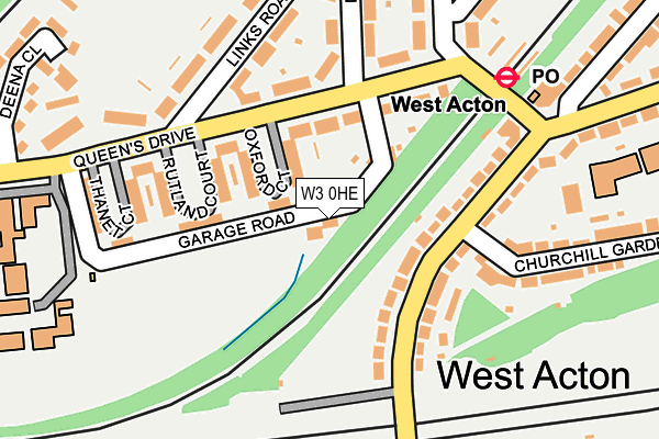
W3 0HE lies on Garage Road in London. W3 0HE is located in the Hanger Hill electoral ward, within the London borough of Ealing and the English Parliamentary constituency of Ealing Central and Acton. The Sub Integrated Care Board (ICB) Location is NHS North West London ICB - W2U3Z and the police force is Metropolitan Police. This postcode has been in use since January 1980.


GetTheData
Source: OS OpenMap – Local (Ordnance Survey)
Source: OS VectorMap District (Ordnance Survey)
Licence: Open Government Licence (requires attribution)
| Easting | 519209 |
| Northing | 181161 |
| Latitude | 51.516802 |
| Longitude | -0.283360 |
GetTheData
Source: Open Postcode Geo
Licence: Open Government Licence
| Street | Garage Road |
| Town/City | London |
| Country | England |
| Postcode District | W3 |
➜ See where W3 is on a map ➜ Where is Acton? | |
GetTheData
Source: Land Registry Price Paid Data
Licence: Open Government Licence
Elevation or altitude of W3 0HE as distance above sea level:
| Metres | Feet | |
|---|---|---|
| Elevation | 30m | 98ft |
Elevation is measured from the approximate centre of the postcode, to the nearest point on an OS contour line from OS Terrain 50, which has contour spacing of ten vertical metres.
➜ How high above sea level am I? Find the elevation of your current position using your device's GPS.
GetTheData
Source: Open Postcode Elevation
Licence: Open Government Licence
| Ward | Hanger Hill |
| Constituency | Ealing Central And Acton |
GetTheData
Source: ONS Postcode Database
Licence: Open Government Licence
| West Acton (Noel Road) | West Acton | 149m |
| Lynton Road (Twyford Avenue) | Acton | 232m |
| West Acton (Noel Road) | West Acton | 263m |
| Lynton Road (Twyford Avenue) | Acton | 298m |
| North Ealing | North Ealing | 555m |
| West Acton Underground Station | West Acton | 212m |
| North Ealing Underground Station | North Ealing | 390m |
| Ealing Common Underground Station | Ealing Common | 816m |
| Park Royal Underground Station | Park Royal | 1,150m |
| Ealing Broadway Underground Station | Ealing Broadway | 1,272m |
| Acton Main Line Station | 1.2km |
| Ealing Broadway Station | 1.3km |
| Acton Central Station | 1.7km |
GetTheData
Source: NaPTAN
Licence: Open Government Licence
| Percentage of properties with Next Generation Access | 100.0% |
| Percentage of properties with Superfast Broadband | 100.0% |
| Percentage of properties with Ultrafast Broadband | 0.0% |
| Percentage of properties with Full Fibre Broadband | 0.0% |
Superfast Broadband is between 30Mbps and 300Mbps
Ultrafast Broadband is > 300Mbps
| Median download speed | 64.1Mbps |
| Average download speed | 57.9Mbps |
| Maximum download speed | 80.00Mbps |
| Median upload speed | 19.5Mbps |
| Average upload speed | 15.9Mbps |
| Maximum upload speed | 20.00Mbps |
| Percentage of properties unable to receive 2Mbps | 0.0% |
| Percentage of properties unable to receive 5Mbps | 0.0% |
| Percentage of properties unable to receive 10Mbps | 0.0% |
| Percentage of properties unable to receive 30Mbps | 0.0% |
GetTheData
Source: Ofcom
Licence: Ofcom Terms of Use (requires attribution)
Estimated total energy consumption in W3 0HE by fuel type, 2015.
| Consumption (kWh) | 85,212 |
|---|---|
| Meter count | 6 |
| Mean (kWh/meter) | 14,202 |
| Median (kWh/meter) | 13,208 |
| Consumption (kWh) | 18,632 |
|---|---|
| Meter count | 7 |
| Mean (kWh/meter) | 2,662 |
| Median (kWh/meter) | 2,791 |
GetTheData
Source: Postcode level gas estimates: 2015 (experimental)
Source: Postcode level electricity estimates: 2015 (experimental)
Licence: Open Government Licence
GetTheData
Source: ONS Postcode Database
Licence: Open Government Licence


➜ Get more ratings from the Food Standards Agency
GetTheData
Source: Food Standards Agency
Licence: FSA terms & conditions
| Last Collection | |||
|---|---|---|---|
| Location | Mon-Fri | Sat | Distance |
| Queens Drive | 17:30 | 12:00 | 143m |
| Post Office 5 Station Parade | 17:30 | 12:00 | 211m |
| Tudor Gardens | 17:30 | 12:00 | 311m |
GetTheData
Source: Dracos
Licence: Creative Commons Attribution-ShareAlike
The below table lists the International Territorial Level (ITL) codes (formerly Nomenclature of Territorial Units for Statistics (NUTS) codes) and Local Administrative Units (LAU) codes for W3 0HE:
| ITL 1 Code | Name |
|---|---|
| TLI | London |
| ITL 2 Code | Name |
| TLI7 | Outer London - West and North West |
| ITL 3 Code | Name |
| TLI73 | Ealing |
| LAU 1 Code | Name |
| E09000009 | Ealing |
GetTheData
Source: ONS Postcode Directory
Licence: Open Government Licence
The below table lists the Census Output Area (OA), Lower Layer Super Output Area (LSOA), and Middle Layer Super Output Area (MSOA) for W3 0HE:
| Code | Name | |
|---|---|---|
| OA | E00006363 | |
| LSOA | E01001274 | Ealing 020G |
| MSOA | E02000257 | Ealing 020 |
GetTheData
Source: ONS Postcode Directory
Licence: Open Government Licence
| W3 0HH | Queens Drive | 80m |
| W3 0HQ | Queens Drive | 86m |
| W3 0JR | Noel Road | 87m |
| W3 0HL | Queens Drive | 108m |
| W3 0HA | Queens Drive | 109m |
| W3 0JP | Noel Road | 115m |
| W3 0HJ | Queens Drive | 120m |
| W3 0HF | Queens Drive | 129m |
| W3 0HG | Queens Drive | 140m |
| W3 0EP | Links Road | 146m |
GetTheData
Source: Open Postcode Geo; Land Registry Price Paid Data
Licence: Open Government Licence