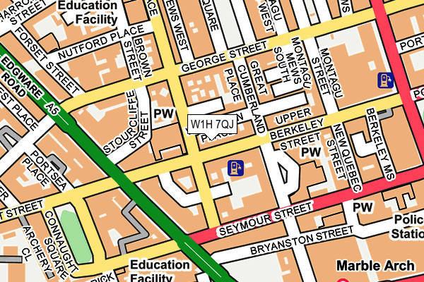
W1H 7QJ lies on Upper Berkeley Street in London. W1H 7QJ is located in the Marylebone electoral ward, within the London borough of Westminster and the English Parliamentary constituency of Cities of London and Westminster. The Sub Integrated Care Board (ICB) Location is NHS North West London ICB - W2U3Z and the police force is Metropolitan Police. This postcode has been in use since December 2000.


GetTheData
Source: OS OpenMap – Local (Ordnance Survey)
Source: OS VectorMap District (Ordnance Survey)
Licence: Open Government Licence (requires attribution)
| Easting | 527701 |
| Northing | 181220 |
| Latitude | 51.515478 |
| Longitude | -0.161018 |
GetTheData
Source: Open Postcode Geo
Licence: Open Government Licence
| Street | Upper Berkeley Street |
| Town/City | London |
| Country | England |
| Postcode District | W1H |
➜ See where W1H is on a map ➜ Where is City of Westminster? | |
GetTheData
Source: Land Registry Price Paid Data
Licence: Open Government Licence
Elevation or altitude of W1H 7QJ as distance above sea level:
| Metres | Feet | |
|---|---|---|
| Elevation | 30m | 98ft |
Elevation is measured from the approximate centre of the postcode, to the nearest point on an OS contour line from OS Terrain 50, which has contour spacing of ten vertical metres.
➜ How high above sea level am I? Find the elevation of your current position using your device's GPS.
GetTheData
Source: Open Postcode Elevation
Licence: Open Government Licence
| Ward | Marylebone |
| Constituency | Cities Of London And Westminster |
GetTheData
Source: ONS Postcode Database
Licence: Open Government Licence
| Marble Arch Edgware Road | Marble Arch | 180m |
| Marble Arch Edgware Road | Marble Arch | 214m |
| George Street (W2) | Lisson Grove | 268m |
| Portman Square | Marble Arch | 273m |
| Marble Arch Bayswater Road | Marble Arch | 275m |
| Marble Arch Underground Station | Marble Arch | 270m |
| Edgware Road (Circle Line) Underground Station | Edgware Road | 679m |
| Marylebone Underground Station | Marylebone | 776m |
| Bond Street Underground Station | Bond Street | 795m |
| Edgware Road (Bakerloo) Underground Station | Edgware Road | 830m |
| London Marylebone Station | 0.8km |
| London Paddington Station | 1.1km |
| London Euston Station | 2.3km |
GetTheData
Source: NaPTAN
Licence: Open Government Licence
Estimated total energy consumption in W1H 7QJ by fuel type, 2015.
| Consumption (kWh) | 79,841 |
|---|---|
| Meter count | 12 |
| Mean (kWh/meter) | 6,653 |
| Median (kWh/meter) | 6,206 |
GetTheData
Source: Postcode level gas estimates: 2015 (experimental)
Source: Postcode level electricity estimates: 2015 (experimental)
Licence: Open Government Licence
GetTheData
Source: ONS Postcode Database
Licence: Open Government Licence


➜ Get more ratings from the Food Standards Agency
GetTheData
Source: Food Standards Agency
Licence: FSA terms & conditions
| Last Collection | |||
|---|---|---|---|
| Location | Mon-Fri | Sat | Distance |
| Great Cumberland Place | 18:30 | 12:00 | 75m |
| Edgware Road | 18:30 | 12:00 | 121m |
| Bryanston Square | 18:30 | 12:00 | 154m |
GetTheData
Source: Dracos
Licence: Creative Commons Attribution-ShareAlike
The below table lists the International Territorial Level (ITL) codes (formerly Nomenclature of Territorial Units for Statistics (NUTS) codes) and Local Administrative Units (LAU) codes for W1H 7QJ:
| ITL 1 Code | Name |
|---|---|
| TLI | London |
| ITL 2 Code | Name |
| TLI3 | Inner London - West |
| ITL 3 Code | Name |
| TLI32 | Westminster |
| LAU 1 Code | Name |
| E09000033 | Westminster |
GetTheData
Source: ONS Postcode Directory
Licence: Open Government Licence
The below table lists the Census Output Area (OA), Lower Layer Super Output Area (LSOA), and Middle Layer Super Output Area (MSOA) for W1H 7QJ:
| Code | Name | |
|---|---|---|
| OA | E00023508 | |
| LSOA | E01004658 | Westminster 012B |
| MSOA | E02000971 | Westminster 012 |
GetTheData
Source: ONS Postcode Directory
Licence: Open Government Licence
| W1H 7BU | Wythburn Place | 19m |
| W1H 7PP | Upper Berkeley Street | 40m |
| W1H 7NS | Seymour Place | 41m |
| W1H 5QD | Upper Berkeley Street | 48m |
| W1H 7TD | Great Cumberland Place | 49m |
| W1H 7TE | Great Cumberland Place | 51m |
| W1H 7LG | Great Cumberland Place | 54m |
| W1H 7TF | Great Cumberland Place | 56m |
| W1H 7LT | Clenston Mews | 57m |
| W1H 5QP | Upper Berkeley Street | 63m |
GetTheData
Source: Open Postcode Geo; Land Registry Price Paid Data
Licence: Open Government Licence