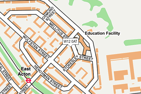
W12 0AT is located in the College Park & Old Oak electoral ward, within the London borough of Hammersmith and Fulham and the English Parliamentary constituency of Hammersmith. The Sub Integrated Care Board (ICB) Location is NHS North West London ICB - W2U3Z and the police force is Metropolitan Police. This postcode has been in use since January 1980.


GetTheData
Source: OS OpenMap – Local (Ordnance Survey)
Source: OS VectorMap District (Ordnance Survey)
Licence: Open Government Licence (requires attribution)
| Easting | 521889 |
| Northing | 181355 |
| Latitude | 51.517974 |
| Longitude | -0.244688 |
GetTheData
Source: Open Postcode Geo
Licence: Open Government Licence
| Country | England |
| Postcode District | W12 |
➜ See where W12 is on a map ➜ Where is Acton? | |
GetTheData
Source: Land Registry Price Paid Data
Licence: Open Government Licence
Elevation or altitude of W12 0AT as distance above sea level:
| Metres | Feet | |
|---|---|---|
| Elevation | 20m | 66ft |
Elevation is measured from the approximate centre of the postcode, to the nearest point on an OS contour line from OS Terrain 50, which has contour spacing of ten vertical metres.
➜ How high above sea level am I? Find the elevation of your current position using your device's GPS.
GetTheData
Source: Open Postcode Elevation
Licence: Open Government Licence
| Ward | College Park & Old Oak |
| Constituency | Hammersmith |
GetTheData
Source: ONS Postcode Database
Licence: Open Government Licence
| Wulfstan Street (Du Cane Road) | White City | 285m |
| East Acton (Fitzneal Street) | East Acton | 292m |
| Wulfstan Street (Du Cane Road) | White City | 326m |
| East Acton Station Fitzneal Street (Du Cane Road) | College Park | 364m |
| The Fairway (W3) (Old Oak Common Lane) | East Acton | 395m |
| East Acton Underground Station | East Acton | 234m |
| North Acton Underground Station | North Acton | 1,214m |
| White City Underground Station | White City | 1,566m |
| Wood Lane Underground Station | Shepherd's Bush | 1,677m |
| Shepherd's Bush Market Underground Station | Shepherd's Bush | 1,876m |
| Acton Main Line Station | 1.5km |
| Willesden Junction Station | 1.6km |
| Acton Central Station | 1.6km |
GetTheData
Source: NaPTAN
Licence: Open Government Licence
| Percentage of properties with Next Generation Access | 100.0% |
| Percentage of properties with Superfast Broadband | 100.0% |
| Percentage of properties with Ultrafast Broadband | 37.5% |
| Percentage of properties with Full Fibre Broadband | 0.0% |
Superfast Broadband is between 30Mbps and 300Mbps
Ultrafast Broadband is > 300Mbps
| Median download speed | 47.0Mbps |
| Average download speed | 47.3Mbps |
| Maximum download speed | 74.00Mbps |
| Median upload speed | 9.9Mbps |
| Average upload speed | 11.7Mbps |
| Maximum upload speed | 20.00Mbps |
| Percentage of properties unable to receive 2Mbps | 0.0% |
| Percentage of properties unable to receive 5Mbps | 0.0% |
| Percentage of properties unable to receive 10Mbps | 0.0% |
| Percentage of properties unable to receive 30Mbps | 0.0% |
GetTheData
Source: Ofcom
Licence: Ofcom Terms of Use (requires attribution)
Estimated total energy consumption in W12 0AT by fuel type, 2015.
| Consumption (kWh) | 78,168 |
|---|---|
| Meter count | 8 |
| Mean (kWh/meter) | 9,771 |
| Median (kWh/meter) | 8,625 |
| Consumption (kWh) | 22,728 |
|---|---|
| Meter count | 8 |
| Mean (kWh/meter) | 2,841 |
| Median (kWh/meter) | 3,025 |
GetTheData
Source: Postcode level gas estimates: 2015 (experimental)
Source: Postcode level electricity estimates: 2015 (experimental)
Licence: Open Government Licence
GetTheData
Source: ONS Postcode Database
Licence: Open Government Licence


➜ Get more ratings from the Food Standards Agency
GetTheData
Source: Food Standards Agency
Licence: FSA terms & conditions
| Last Collection | |||
|---|---|---|---|
| Location | Mon-Fri | Sat | Distance |
| Wulfstan Road | 17:30 | 12:00 | 131m |
| East Acton Post Office | 18:30 | 12:00 | 463m |
| Brunel Road | 17:30 | 12:00 | 483m |
GetTheData
Source: Dracos
Licence: Creative Commons Attribution-ShareAlike
The below table lists the International Territorial Level (ITL) codes (formerly Nomenclature of Territorial Units for Statistics (NUTS) codes) and Local Administrative Units (LAU) codes for W12 0AT:
| ITL 1 Code | Name |
|---|---|
| TLI | London |
| ITL 2 Code | Name |
| TLI3 | Inner London - West |
| ITL 3 Code | Name |
| TLI33 | Kensington & Chelsea and Hammersmith & Fulham |
| LAU 1 Code | Name |
| E09000013 | Hammersmith and Fulham |
GetTheData
Source: ONS Postcode Directory
Licence: Open Government Licence
The below table lists the Census Output Area (OA), Lower Layer Super Output Area (LSOA), and Middle Layer Super Output Area (MSOA) for W12 0AT:
| Code | Name | |
|---|---|---|
| OA | E00009374 | |
| LSOA | E01001878 | Hammersmith and Fulham 001E |
| MSOA | E02000372 | Hammersmith and Fulham 001 |
GetTheData
Source: ONS Postcode Directory
Licence: Open Government Licence
| W12 0BX | Erconwald Street | 58m |
| W12 0BU | Erconwald Street | 62m |
| W12 0AG | Stokesley Street | 62m |
| W12 0AL | Braybrook Street | 117m |
| W12 0BT | Erconwald Street | 132m |
| W12 0AH | Wulfstan Street | 144m |
| W12 0AR | Braybrook Street | 148m |
| W12 0AP | Braybrook Street | 157m |
| W12 0AU | Mellitus Street | 163m |
| W12 0AD | Wulfstan Street | 172m |
GetTheData
Source: Open Postcode Geo; Land Registry Price Paid Data
Licence: Open Government Licence